Written and Fact-checked by Whereig Editors, Reviewed by Mukesh Kumar| Updated On: May 15, 2026
Map of Eddy County - Eddy County is a county located in the U.S. state of New Mexico. Eddy County Map showing cities, highways, important places and water bodies. Get Where is Eddy County located in the map, major cities in Eddy county, population, areas, and places of interest.
Map of Eddy County, New Mexico
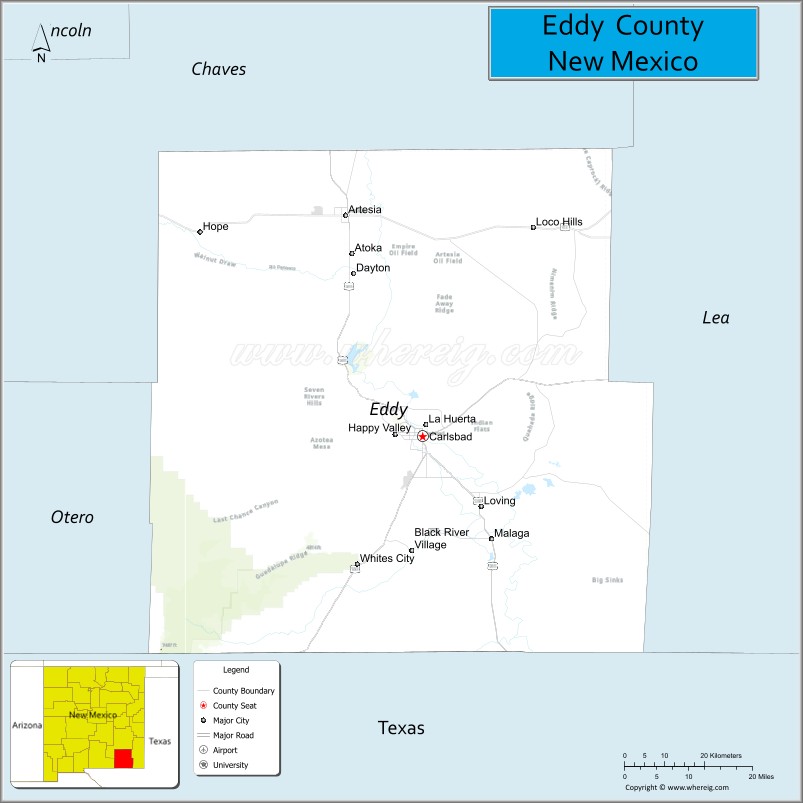
About Eddy County Map, New Mexico: The map showing the county boundary, county seat, major cities, highways, water bodies and neighbouring counties.
Other New Mexico Maps & Info
About Eddy County, New Mexico
Eddy County is a county located in the U.S. state of New Mexico. It's county seat is Carlsbad. As per 2020 census, the population of Eddy County is 60911 people and population density is square miles. According to the United States Census Bureau, the county has a total area of 4,182 sq mi (10,831 km2). Eddy County was established on 1887.
Eddy County Facts
| Continent | North America |
| Country | United States |
| State | New Mexico |
| County Seat | Carlsbad |
| Largest City/Town | Carlsbad |
| Established | 1889 |
| Total Area | 4,198 sq mi (10,873 sq km) |
| Land Area | 4,176 sq mi (10,816 sq km) |
| Water Area | 22 sq mi (57 sq km) |
| Population | 62,314 (Census 2020) |
| Population Density | 14.9 people per sq mi |
| Time Zone | Mountain Time Zone |
| Major Highways | U.S. Highway 62, U.S. Highway 180, U.S. Highway 285, U.S. Highway 82, State Road 31 |
| Major Rivers | Pecos River, Black River |
| Neighboring Counties | Chaves County, Lea County, Otero County, Culberson County (Texas), Loving County (Texas), Reeves County (Texas) |
| Famous For | Carlsbad Caverns National Park, oil and gas production, Pecos River recreation, and desert landscapes |
| Top Attractions | Carlsbad Caverns National Park, Living Desert Zoo and Gardens State Park, Brantley Lake State Park, and Sitting Bull Falls |
| Official Website | Official Website |
About Eddy County, New Mexico
Eddy County is located in southeastern New Mexico along the Texas border and was established in 1889. The county seat is Carlsbad, which is also the largest city and an important center for energy production and tourism in the region. The county is known for underground cave systems, desert mountains, ranching, and major oil and gas activity within the Permian Basin.
Cities and Towns in Eddy County, New Mexico
| City/Town | Population (Census 2020) | Latitude & Longitude |
|---|---|---|
| Carlsbad (county seat) | 32,238 | 32.4207°N, 104.2288°W |
| Artesia | 12,875 | 32.8423°N, 104.4033°W |
| Loving | 1,245 | 32.2868°N, 104.0969°W |
| Hope | 105 | 32.8090°N, 104.7397°W |
| Lake Arthur (partly) | 432 | 32.9995°N, 104.3708°W |
| Maljamar (CDP) | 186 | 33.0392°N, 103.7628°W |
| Queen (CDP) | 57 | 32.1945°N, 104.7336°W |
| Otis (CDP) | 224 | 32.7612°N, 104.0647°W |
| Whites City (CDP) | 7 | 32.1767°N, 104.3786°W |
Golf Courses in Eddy County, New Mexico
| Golf Course | Location | Latitude & Longitude |
|---|---|---|
| Lake Carlsbad Golf Course | Carlsbad | 32.4325°N, 104.2356°W |
| Riverside Country Club | Carlsbad | 32.4381°N, 104.2489°W |
| Artesia Country Club | Artesia | 32.8542°N, 104.4314°W |
| Desert Lakes Golf Course | Artesia | 32.8561°N, 104.4255°W |
Roads and Highways in Eddy County, New Mexico
Major highways connect the county to nearby regions and cities.
- U.S. Highway 62 - east-west highway connecting Carlsbad with Texas and southeastern New Mexico
- U.S. Highway 180 - scenic route linking Carlsbad with El Paso and western New Mexico
- U.S. Highway 285 - major north-south corridor connecting Artesia, Carlsbad, and Texas oil regions
- U.S. Highway 82 - highway connecting Artesia with Alamogordo and west Texas
- State Road 31 - route serving oilfield areas and rural communities
Neighboring Counties of Eddy County
- Chaves County (north)
- Lea County (east)
- Otero County (west)
- Culberson County, Texas (southwest)
- Reeves County, Texas (south)
- Loving County, Texas (southeast)
Top Attractions in Eddy County, New Mexico
The county offers a mix of natural and cultural attractions.
- Carlsbad Caverns National Park - world-famous cave system with underground chambers and bat flights
- Living Desert Zoo and Gardens State Park - desert wildlife park featuring native plants and animals
- Brantley Lake State Park - recreation area for boating, camping, and fishing
- Sitting Bull Falls - scenic waterfall and canyon oasis in the Guadalupe Mountains
- Lake Carlsbad Recreation Area - public park and recreation area along the Pecos River
- Carlsbad Museum and Art Center - museum with regional history and Southwestern art exhibits
- Guadalupe Mountains Scenic Drives - desert mountain routes with hiking and photography opportunities
- Whites City - gateway community to Carlsbad Caverns National Park
- Pecos Riverwalk - walking and recreation area in downtown Carlsbad
- Artesia Historical Museum and Art Center - local museum focused on oil, ranching, and pioneer history
- Ocotillo Hills Nature Trail - hiking trail with desert views and wildlife watching
- Black River Recreation Areas - fishing and outdoor recreation spots near the Texas border
Distance from Eddy County to Nearby Cities
The following distances are measured by road (driving).
- Carlsbad to Roswell (Chaves County), New Mexico - 76 mi (122 km)
- Carlsbad to Hobbs (Lea County), New Mexico - 71 mi (114 km)
- Carlsbad to Artesia (Eddy County), New Mexico - 39 mi (63 km)
- Carlsbad to El Paso (El Paso County), Texas - 169 mi (272 km)
- Carlsbad to Albuquerque (Bernalillo County), New Mexico - 276 mi (444 km)
- Carlsbad to Midland (Midland County), Texas - 144 mi (232 km)
- Carlsbad to Odessa (Ector County), Texas - 131 mi (211 km)
- Carlsbad to Las Cruces (Dona Ana County), New Mexico - 188 mi (303 km)
- Carlsbad to Lubbock (Lubbock County), Texas - 176 mi (283 km)
- Carlsbad to Amarillo (Potter County), Texas - 291 mi (468 km)
- Carlsbad to Alamogordo (Otero County), New Mexico - 160 mi (257 km)
- Carlsbad to Santa Fe (Santa Fe County), New Mexico - 286 mi (460 km)
FAQs about Eddy County
Eddy County is located in southeastern New Mexico along the Texas border.
The population of Eddy County was 62,314 according to the Census 2020.
Eddy County is known for Carlsbad Caverns National Park, oil production, desert recreation, and Pecos River scenery.
The county is served by U.S. Highway 62, U.S. Highway 180, U.S. Highway 285, and U.S. Highway 82.
Yes, Eddy County has several golf facilities including Lake Carlsbad Golf Course and Artesia Country Club.
References
- QuickFacts - U.S. Census Bureau
- United States Census Bureau
- United States Geological Survey (USGS)
- National Geodetic Survey
- Official County Website
- Bernalillo County Map
- Catron County Map
- Chaves County Map
- Cibola County Map
- Colfax County Map
- Curry County Map
- De Baca County Map
- Doña Ana County Map
- Eddy County Map
- Grant County Map
- Guadalupe County Map
- Harding County Map
- Hidalgo County Map
- Lea County Map
- Lincoln County Map
- Los Alamos County Map
- Luna County Map
- McKinley County Map
- Mora County Map
- Otero County Map
- Quay County Map
- Rio Arriba County Map
- Roosevelt County Map
- Sandoval County Map
- San Juan County Map
- San Miguel County Map
- Santa Fe County Map
- Sierra County Map
- Socorro County Map
- Taos County Map
- Torrance County Map
- Union County Map
- Valencia County Map
- Alabama Counties
- Alaska boroughs
- Arizona Counties
- Arkansas Counties
- California County Map
- Colorado Counties
- Connecticut Counties
- Delaware Counties
- Florida County Map
- Georgia County Map
- Hawaii Counties
- Idaho Counties
- Illinois Counties
- Indiana Counties
- Iowa Counties
- Kansas Counties
- Kentucky Counties
- Louisiana Counties
- Maine Counties
- Maryland Counties
- Massachusetts Counties
- Michigan County Map
- Minnesota Counties
- Mississippi Counties
- Missouri Counties
- Montana Counties
- Nebraska Counties
- Nevada Counties
- New York Counties
- New Hampshire Counties
- New Jersey Counties
- New Mexico Counties
- North Carolina Counties
- North Dakota Counties
- Ohio County Map
- Oklahoma Counties
- Oregon Counties
- Pennsylvania Counties
- Rhode Island Counties
- South Carolina Counties
- South Dakota Counties
- Map of Tennessee
- Texas County Map
- Utah Counties
- Vermont Counties
- Virginia Counties
- Washington Counties
- West Virginia Counties
- Wisconsin Counties
- Wyoming Counties