Written and Fact-checked by Whereig Editors, Reviewed by Mukesh Kumar| Updated On: May 15, 2026
Map of Sierra County - Sierra County is a county located in the U.S. state of New Mexico. Sierra County Map showing cities, highways, important places and water bodies. Get Where is Sierra County located in the map, major cities in Sierra county, population, areas, and places of interest.
Map of Sierra County, New Mexico
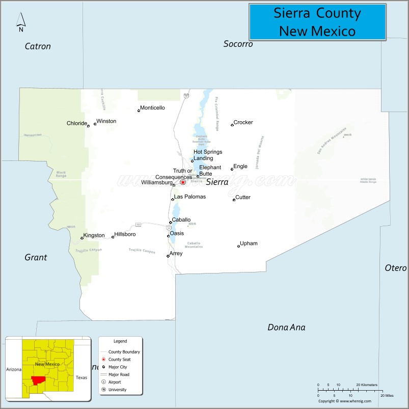
About Sierra County Map, New Mexico: The map showing the county boundary, county seat, major cities, highways, water bodies and neighbouring counties.
Other New Mexico Maps & Info
About Sierra County, New Mexico
Sierra County is a county located in the U.S. state of New Mexico. It's county seat is Truth or Consequences. As per 2020 census, the population of Sierra County is 11502 people and population density is square miles. According to the United States Census Bureau, the county has a total area of 4,180 sq mi (10,826 km2). Sierra County was established on 1884.
Sierra County Facts
| Continent | North America |
| Country | United States |
| State | New Mexico |
| County Seat | Truth or Consequences |
| Largest City/Town | Truth or Consequences |
| Established | 1884 |
| Total Area | 4,236 sq mi (10,971 sq km) |
| Land Area | 4,179 sq mi (10,823 sq km) |
| Water Area | 57 sq mi (148 sq km) |
| Population | 11,576 (Census 2020) |
| Population Density | 2.8 people per sq mi |
| Time Zone | Mountain Time Zone |
| Major Highways | Interstate 25, U.S. Highway 70, State Road 52, State Road 181 |
| Major Rivers | Rio Grande, Palomas Creek |
| Neighboring Counties | Socorro County, Lincoln County, Otero County, Dona Ana County, Luna County, Grant County, Catron County |
| Famous For | Elephant Butte Lake, hot springs, Spaceport America, and desert mountain scenery |
| Top Attractions | Elephant Butte Lake State Park, Truth or Consequences hot springs, Spaceport America, and Caballo Lake |
| Official Website | Official Website |
About Sierra County, New Mexico
Sierra County is located in southern New Mexico and was established in 1884. The county seat and largest city is Truth or Consequences, a unique community famous for its natural hot springs and historic name change tied to a television game show. The county is known for large reservoirs, desert recreation, mining history, and Spaceport America.
Cities and Towns in Sierra County, New Mexico
| City/Town | Population (Census 2020) | Latitude & Longitude |
|---|---|---|
| Truth or Consequences (county seat) | 6,052 | 33.1284°N, 107.2528°W |
| Elephant Butte | 1,431 | 33.1776°N, 107.2134°W |
| Williamsburg | 449 | 32.9881°N, 107.2947°W |
| Hillsboro | 124 | 32.9200°N, 107.5681°W |
| Caballo | 111 | 32.9061°N, 107.2953°W |
| Arrey | 232 | 32.7670°N, 107.3289°W |
| Kingston | Historic mountain community | 32.9170°N, 107.7086°W |
| Winston | Historic rural community | 33.3508°N, 107.6572°W |
| Monticello | Historic village | 33.3989°N, 107.5939°W |
| Spaceport City area | Developing region | 32.9903°N, 106.9742°W |
Golf Courses in Sierra County, New Mexico
| Golf Course | Location | Latitude & Longitude |
|---|---|---|
| Sierra del Rio Golf Course | Elephant Butte | 33.1842°N, 107.2297°W |
| Truth or Consequences Municipal Golf Course | Truth or Consequences | 33.1356°N, 107.2622°W |
Roads and Highways in Sierra County, New Mexico
Major highways connect the county to southern New Mexico recreation areas and transportation corridors.
- Interstate 25 - major north-south interstate connecting Truth or Consequences with Albuquerque and Las Cruces
- U.S. Highway 70 - east-west highway linking the county with eastern and southern New Mexico
- State Road 52 - scenic route serving rural ranching communities and mountain regions
- State Road 181 - regional highway connecting agricultural communities along the Rio Grande
Neighboring Counties of Sierra County
- Socorro County (north)
- Lincoln County (northeast)
- Otero County (east)
- Dona Ana County (south)
- Luna County (southwest)
- Grant County (west)
- Catron County (northwest)
Top Attractions in Sierra County, New Mexico
The county offers a mix of outdoor, scientific, and historical attractions.
- Elephant Butte Lake State Park - largest lake in New Mexico known for boating, fishing, and camping
- Truth or Consequences Hot Springs District - historic bathhouses and geothermal spas
- Spaceport America - commercial space launch facility and visitor center
- Caballo Lake State Park - recreation area popular for boating and birdwatching
- Geronimo Springs Museum - local history museum in Truth or Consequences
- Hillsboro Historic District - preserved mining town with Old West charm
- Kingston Ghost Town - former silver mining community in the Black Range Mountains
- Percha Box Recreation Area - scenic hiking and camping destination
- Rio Grande fishing and rafting areas - outdoor recreation opportunities along the river
- Black Range mountain drives - scenic forest and canyon landscapes
- Bosque del Apache National Wildlife Refuge nearby - internationally known birdwatching area
- Caballo Mountains hiking areas - desert mountain recreation and photography locations
Distance from Sierra County to Nearby Cities
The following distances are measured by road (driving).
- Truth or Consequences to Las Cruces (Dona Ana County), New Mexico - 75 mi (121 km)
- Truth or Consequences to Socorro (Socorro County), New Mexico - 75 mi (121 km)
- Truth or Consequences to Albuquerque (Bernalillo County), New Mexico - 150 mi (241 km)
- Truth or Consequences to Alamogordo (Otero County), New Mexico - 109 mi (175 km)
- Truth or Consequences to Silver City (Grant County), New Mexico - 100 mi (161 km)
- Truth or Consequences to Roswell (Chaves County), New Mexico - 168 mi (270 km)
- Truth or Consequences to El Paso (El Paso County), Texas - 151 mi (243 km)
- Truth or Consequences to Santa Fe (Santa Fe County), New Mexico - 214 mi (344 km)
- Truth or Consequences to Tucson (Pima County), Arizona - 343 mi (552 km)
- Truth or Consequences to Phoenix (Maricopa County), Arizona - 410 mi (660 km)
- Truth or Consequences to Amarillo (Potter County), Texas - 363 mi (584 km)
- Truth or Consequences to Denver (Denver County), Colorado - 478 mi (769 km)
FAQs about Sierra County
Sierra County is located in southern New Mexico along the Rio Grande corridor.
The population of Sierra County was 11,576 according to the Census 2020.
Sierra County is known for Elephant Butte Lake, hot springs, desert recreation, and Spaceport America.
The county is served by Interstate 25, U.S. Highway 70, State Road 52, and State Road 181.
Yes, Sierra County has golf facilities including Sierra del Rio Golf Course and Truth or Consequences Municipal Golf Course.
References
- QuickFacts - U.S. Census Bureau
- United States Census Bureau
- United States Geological Survey (USGS)
- National Geodetic Survey
- Official County Website
- Bernalillo County Map
- Catron County Map
- Chaves County Map
- Cibola County Map
- Colfax County Map
- Curry County Map
- De Baca County Map
- Doña Ana County Map
- Eddy County Map
- Grant County Map
- Guadalupe County Map
- Harding County Map
- Hidalgo County Map
- Lea County Map
- Lincoln County Map
- Los Alamos County Map
- Luna County Map
- McKinley County Map
- Mora County Map
- Otero County Map
- Quay County Map
- Rio Arriba County Map
- Roosevelt County Map
- Sandoval County Map
- San Juan County Map
- San Miguel County Map
- Santa Fe County Map
- Sierra County Map
- Socorro County Map
- Taos County Map
- Torrance County Map
- Union County Map
- Valencia County Map
- Alabama Counties
- Alaska boroughs
- Arizona Counties
- Arkansas Counties
- California County Map
- Colorado Counties
- Connecticut Counties
- Delaware Counties
- Florida County Map
- Georgia County Map
- Hawaii Counties
- Idaho Counties
- Illinois Counties
- Indiana Counties
- Iowa Counties
- Kansas Counties
- Kentucky Counties
- Louisiana Counties
- Maine Counties
- Maryland Counties
- Massachusetts Counties
- Michigan County Map
- Minnesota Counties
- Mississippi Counties
- Missouri Counties
- Montana Counties
- Nebraska Counties
- Nevada Counties
- New York Counties
- New Hampshire Counties
- New Jersey Counties
- New Mexico Counties
- North Carolina Counties
- North Dakota Counties
- Ohio County Map
- Oklahoma Counties
- Oregon Counties
- Pennsylvania Counties
- Rhode Island Counties
- South Carolina Counties
- South Dakota Counties
- Map of Tennessee
- Texas County Map
- Utah Counties
- Vermont Counties
- Virginia Counties
- Washington Counties
- West Virginia Counties
- Wisconsin Counties
- Wyoming Counties