
Written and Fact-checked by Whereig Editors, Reviewed by Mukesh Kumar| Updated On: May 15, 2026
Map of Catron County - Catron County is a county located in the U.S. state of New Mexico. Catron County Map showing cities, highways, important places and water bodies. Get Where is Catron County located in the map, major cities in Catron county, population, areas, and places of interest.
Map of Catron County, New Mexico
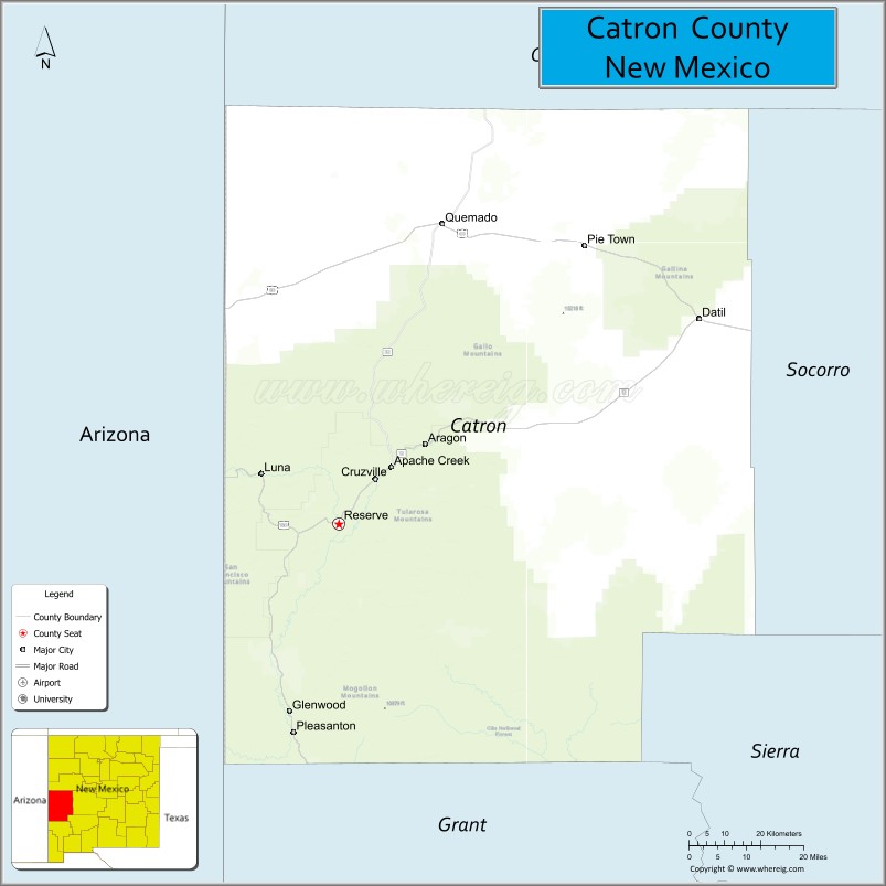
About Catron County Map, New Mexico: The map showing the county boundary, county seat, major cities, highways, water bodies and neighbouring counties.
Other New Mexico Maps & Info
About Catron County, New Mexico
Catron County is a county located in the U.S. state of New Mexico. It's county seat is Reserve. As per 2020 census, the population of Catron County is 3731 people and population density is square miles. According to the United States Census Bureau, the county has a total area of 6,928 sq mi (17,943 km2). Catron County was established on 1921.
Catron County Facts
| Continent | North America |
| Country | United States |
| State | New Mexico |
| County Seat | Reserve |
| Largest City/Town | Reserve |
| Established | 1921 |
| Total Area | 6,929 sq mi (17,946 sq km) |
| Land Area | 6,928 sq mi (17,943 sq km) |
| Water Area | 1 sq mi (3 sq km) |
| Population | 3,579 (Census 2020) |
| Population Density | 0.5 people per sq mi |
| Time Zone | Mountain Time Zone |
| Major Highways | U.S. Highway 180, State Road 12, State Road 32, State Road 36 |
| Major Rivers | San Francisco River, Gila River |
| Neighboring Counties | Cibola County, Socorro County, Sierra County, Grant County, Hidalgo County, Apache County (Arizona), Greenlee County (Arizona) |
| Famous For | Gila Wilderness, rugged mountain landscapes, elk hunting, and remote scenic areas |
| Top Attractions | Gila National Forest, Gila Wilderness, Catwalk Recreation Area, and Quemado Lake |
| Official Website | Official Website |
About Catron County, New Mexico
Catron County is located in western New Mexico near the Arizona border and was established in 1921. The county seat is Reserve, which is also the largest community in the county. Catron County is one of the largest counties in the United States by land area and is known for its remote wilderness, mountain forests, rivers, and exceptional outdoor recreation opportunities.
Cities and Towns in Catron County, New Mexico
| City/Town | Population (Census 2020) | Latitude & Longitude |
|---|---|---|
| Reserve (county seat) | 289 | 33.7139°N, 108.7573°W |
| Quemado | 230 | 34.3584°N, 108.4912°W |
| Glenwood (CDP) | 143 | 33.3176°N, 108.8845°W |
| Luna (CDP) | 158 | 33.8195°N, 108.9440°W |
| Pleasanton (CDP) | 106 | 33.2731°N, 108.8806°W |
| Apache Creek (CDP) | 67 | 33.9050°N, 108.6895°W |
| Pie Town (CDP) | 186 | 34.2992°N, 108.1431°W |
| Datil (CDP) | 54 | 34.1456°N, 107.8431°W |
Golf Courses in Catron County, New Mexico
| Golf Course | Location | Latitude & Longitude |
|---|---|---|
| Quemado Lake Golf Course | Quemado | 34.3965°N, 108.5032°W |
| Reserve Community Golf Area | Reserve | 33.7189°N, 108.7608°W |
Roads and Highways in Catron County, New Mexico
Major highways connect the county to nearby regions and cities.
- U.S. Highway 180 - scenic highway connecting Reserve with Silver City and Arizona
- State Road 12 - route linking Reserve with Datil and western mountain areas
- State Road 32 - connects Quemado with Apache Creek and southern communities
- State Road 36 - serves remote northern areas and ranching communities
Neighboring Counties of Catron County
- Cibola County (north)
- Socorro County (east)
- Sierra County (southeast)
- Grant County (south)
- Hidalgo County (southwest)
- Greenlee County, Arizona (west)
- Apache County, Arizona (northwest)
Top Attractions in Catron County, New Mexico
The county offers a mix of natural and cultural attractions.
- Gila Wilderness - one of the first designated wilderness areas in the United States with hiking and wildlife viewing
- Gila National Forest - vast forest area offering camping, fishing, and scenic mountain drives
- Catwalk Recreation Area - historic canyon walkway and hiking destination near Glenwood
- Quemado Lake - recreation lake known for fishing, boating, and camping
- Pie Town - famous small community known for homemade pies and the Continental Divide Trail
- San Francisco River Area - scenic river corridor with birdwatching and outdoor recreation
- Luna Lake Region - nearby mountain recreation area with fishing and forest scenery
- Datil Well Recreation Area - campground and picnic area along historic travel routes
- Apache Creek Historic Sites - frontier history and ranching heritage locations
- Continental Divide Trail - nationally known hiking trail crossing through the county
- Reserve Ranger District Scenic Drives - mountain and forest routes with wildlife viewing opportunities
- Mogollon Mountains - rugged peaks and wilderness landscapes popular with hikers and hunters
Distance from Catron County to Nearby Cities
The following distances are measured by road (driving).
- Reserve to Silver City (Grant County), New Mexico - 99 mi (159 km)
- Reserve to Socorro (Socorro County), New Mexico - 150 mi (241 km)
- Reserve to Springerville (Apache County), Arizona - 74 mi (119 km)
- Reserve to Albuquerque (Bernalillo County), New Mexico - 247 mi (398 km)
- Reserve to Gallup (McKinley County), New Mexico - 176 mi (283 km)
- Reserve to Las Cruces (Dona Ana County), New Mexico - 214 mi (344 km)
- Reserve to Show Low (Navajo County), Arizona - 146 mi (235 km)
- Reserve to Tucson (Pima County), Arizona - 285 mi (459 km)
- Reserve to Phoenix (Maricopa County), Arizona - 310 mi (499 km)
- Reserve to Deming (Luna County), New Mexico - 176 mi (283 km)
- Reserve to Truth or Consequences (Sierra County), New Mexico - 173 mi (278 km)
- Reserve to Farmington (San Juan County), New Mexico - 322 mi (518 km)
FAQs about Catron County
Catron County is located in western New Mexico near the Arizona border.
The population of Catron County was 3,579 according to the Census 2020.
Catron County is known for the Gila Wilderness, mountain scenery, hunting, and remote outdoor recreation.
The county is served by U.S. Highway 180 and several New Mexico state roads including State Road 12 and State Road 32.
Yes, Catron County has small community golf facilities near Quemado and Reserve.
References
- QuickFacts - U.S. Census Bureau
- United States Census Bureau
- United States Geological Survey (USGS)
- National Geodetic Survey
- Official County Website
- Bernalillo County Map
- Catron County Map
- Chaves County Map
- Cibola County Map
- Colfax County Map
- Curry County Map
- De Baca County Map
- Doña Ana County Map
- Eddy County Map
- Grant County Map
- Guadalupe County Map
- Harding County Map
- Hidalgo County Map
- Lea County Map
- Lincoln County Map
- Los Alamos County Map
- Luna County Map
- McKinley County Map
- Mora County Map
- Otero County Map
- Quay County Map
- Rio Arriba County Map
- Roosevelt County Map
- Sandoval County Map
- San Juan County Map
- San Miguel County Map
- Santa Fe County Map
- Sierra County Map
- Socorro County Map
- Taos County Map
- Torrance County Map
- Union County Map
- Valencia County Map
- Alabama Counties
- Alaska boroughs
- Arizona Counties
- Arkansas Counties
- California County Map
- Colorado Counties
- Connecticut Counties
- Delaware Counties
- Florida County Map
- Georgia County Map
- Hawaii Counties
- Idaho Counties
- Illinois Counties
- Indiana Counties
- Iowa Counties
- Kansas Counties
- Kentucky Counties
- Louisiana Counties
- Maine Counties
- Maryland Counties
- Massachusetts Counties
- Michigan County Map
- Minnesota Counties
- Mississippi Counties
- Missouri Counties
- Montana Counties
- Nebraska Counties
- Nevada Counties
- New York Counties
- New Hampshire Counties
- New Jersey Counties
- New Mexico Counties
- North Carolina Counties
- North Dakota Counties
- Ohio County Map
- Oklahoma Counties
- Oregon Counties
- Pennsylvania Counties
- Rhode Island Counties
- South Carolina Counties
- South Dakota Counties
- Map of Tennessee
- Texas County Map
- Utah Counties
- Vermont Counties
- Virginia Counties
- Washington Counties
- West Virginia Counties
- Wisconsin Counties
- Wyoming Counties