Written and Fact-checked by Whereig Editors, Reviewed by Mukesh Kumar| Updated On: May 15, 2026
Map of Grant County - Grant County is a county located in the U.S. state of New Mexico. Grant County Map showing cities, highways, important places and water bodies. Get Where is Grant County located in the map, major cities in Grant county, population, areas, and places of interest.
Map of Grant County, New Mexico
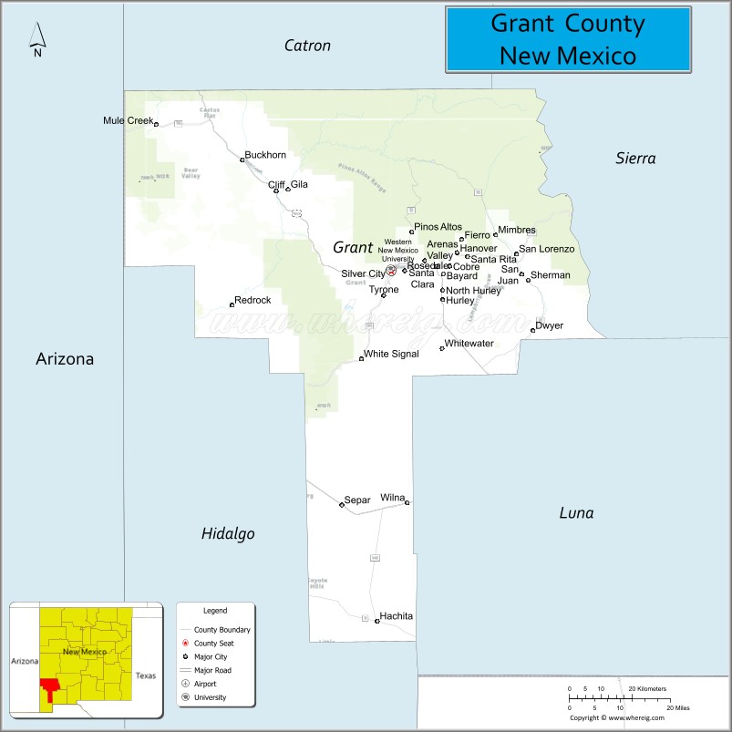
About Grant County Map, New Mexico: The map showing the county boundary, county seat, major cities, highways, water bodies and neighbouring counties.
Other New Mexico Maps & Info
About Grant County, New Mexico
Grant County is a county located in the U.S. state of New Mexico. It's county seat is Silver City. As per 2020 census, the population of Grant County is 27889 people and population density is square miles. According to the United States Census Bureau, the county has a total area of 3,966 sq mi (10,272 km2). Grant County was established on 1868.
Grant County Facts
| Continent | North America |
| Country | United States |
| State | New Mexico |
| County Seat | Silver City |
| Largest City/Town | Silver City |
| Established | 1868 |
| Total Area | 3,968 sq mi (10,277 sq km) |
| Land Area | 3,962 sq mi (10,261 sq km) |
| Water Area | 6 sq mi (16 sq km) |
| Population | 28,185 (Census 2020) |
| Population Density | 7.1 people per sq mi |
| Time Zone | Mountain Time Zone |
| Major Highways | U.S. Highway 180, U.S. Highway 70, State Road 90, State Road 152, State Road 35 |
| Major Rivers | Gila River, Mimbres River |
| Neighboring Counties | Catron County, Sierra County, Luna County, Hidalgo County, Greenlee County (Arizona) |
| Famous For | Gila Wilderness, mining history, Western New Mexico University, and mountain landscapes |
| Top Attractions | Gila Cliff Dwellings National Monument, City of Rocks State Park, Historic Downtown Silver City, and Gila National Forest |
| Official Website | Official Website |
About Grant County, New Mexico
Grant County is located in southwestern New Mexico and was established in 1868 during the territorial period. The county seat is Silver City, which is also the largest town and a major cultural and educational center in the region. The county is known for rugged mountain scenery, historic mining communities, wilderness recreation, and rich Native American and frontier history.
Cities and Towns in Grant County, New Mexico
| City/Town | Population (Census 2020) | Latitude & Longitude |
|---|---|---|
| Silver City (county seat) | 9,704 | 32.7701°N, 108.2803°W |
| Bayard | 2,328 | 32.7612°N, 108.1331°W |
| Santa Clara | 1,637 | 32.7806°N, 108.1517°W |
| Hurley | 1,178 | 32.6995°N, 108.1311°W |
| Tyrone (CDP) | 637 | 32.6990°N, 108.3417°W |
| Cliff-Gila (CDP) | 1,728 | 32.9645°N, 108.6114°W |
| Mimbres (CDP) | 667 | 32.8603°N, 107.9795°W |
| Pinos Altos (CDP) | 198 | 32.8706°N, 108.2170°W |
| Hanover (CDP) | 172 | 32.8145°N, 108.1148°W |
| Faywood (CDP) | 52 | 32.6408°N, 107.8789°W |
Golf Courses in Grant County, New Mexico
| Golf Course | Location | Latitude & Longitude |
|---|---|---|
| Silver City Golf Course | Silver City | 32.7789°N, 108.2731°W |
| Scott Park Golf Links | Silver City | 32.7762°N, 108.2814°W |
| Tyrone Country Club Golf Course | Tyrone | 32.7017°N, 108.3390°W |
Roads and Highways in Grant County, New Mexico
Major highways connect the county to nearby regions and cities.
- U.S. Highway 180 - major route connecting Silver City with Arizona and Deming
- U.S. Highway 70 - highway linking Grant County with Las Cruces and Arizona
- State Road 90 - scenic route serving mining communities and ranching areas
- State Road 152 - mountain highway connecting Silver City with Hillsboro and the Black Range
- State Road 35 - road leading toward the Gila Cliff Dwellings area
Neighboring Counties of Grant County
- Catron County (north)
- Sierra County (east)
- Luna County (south)
- Hidalgo County (southwest)
- Greenlee County, Arizona (west)
Top Attractions in Grant County, New Mexico
The county offers a mix of natural and cultural attractions.
- Gila Cliff Dwellings National Monument - ancient Mogollon cliff dwellings located within the Gila Wilderness
- City of Rocks State Park - unique volcanic rock formations and desert camping area
- Historic Downtown Silver City - arts district with galleries, restaurants, and preserved architecture
- Gila National Forest - expansive forest area offering hiking, camping, and wildlife viewing
- Western New Mexico University Museum - museum featuring Native American pottery and regional history
- Big Ditch Park - urban green space and walking trail through Silver City
- Faywood Hot Springs - natural hot spring resort and relaxation destination
- Pinos Altos Historic Town - former mining town with Old West history and preserved buildings
- Lake Roberts Recreation Area - fishing, boating, and mountain camping destination
- Continental Divide Trail - nationally recognized hiking trail crossing the county
- Fort Bayard Historic District - former military fort and veterans facility with museums and trails
- Mimbres Culture Heritage Sites - archaeological areas showcasing ancient Native American culture
Distance from Grant County to Nearby Cities
The following distances are measured by road (driving).
- Silver City to Deming (Luna County), New Mexico - 58 mi (93 km)
- Silver City to Las Cruces (Dona Ana County), New Mexico - 113 mi (182 km)
- Silver City to Lordsburg (Hidalgo County), New Mexico - 67 mi (108 km)
- Silver City to Albuquerque (Bernalillo County), New Mexico - 237 mi (381 km)
- Silver City to Tucson (Pima County), Arizona - 215 mi (346 km)
- Silver City to Phoenix (Maricopa County), Arizona - 275 mi (443 km)
- Silver City to El Paso (El Paso County), Texas - 165 mi (266 km)
- Silver City to Roswell (Chaves County), New Mexico - 219 mi (352 km)
- Silver City to Alamogordo (Otero County), New Mexico - 177 mi (285 km)
- Silver City to Truth or Consequences (Sierra County), New Mexico - 106 mi (171 km)
- Silver City to Farmington (San Juan County), New Mexico - 397 mi (639 km)
- Silver City to Flagstaff (Coconino County), Arizona - 405 mi (652 km)
FAQs about Grant County
Grant County is located in southwestern New Mexico near the Arizona border.
The population of Grant County was 28,185 according to the Census 2020.
Grant County is known for the Gila Wilderness, mining history, mountain scenery, and historic Silver City.
The county is served by U.S. Highway 180, U.S. Highway 70, and several scenic state highways.
Yes, Grant County has golf facilities including Silver City Golf Course and Tyrone Country Club Golf Course.
References
- QuickFacts - U.S. Census Bureau
- United States Census Bureau
- United States Geological Survey (USGS)
- National Geodetic Survey
- Official County Website
- Bernalillo County Map
- Catron County Map
- Chaves County Map
- Cibola County Map
- Colfax County Map
- Curry County Map
- De Baca County Map
- Doña Ana County Map
- Eddy County Map
- Grant County Map
- Guadalupe County Map
- Harding County Map
- Hidalgo County Map
- Lea County Map
- Lincoln County Map
- Los Alamos County Map
- Luna County Map
- McKinley County Map
- Mora County Map
- Otero County Map
- Quay County Map
- Rio Arriba County Map
- Roosevelt County Map
- Sandoval County Map
- San Juan County Map
- San Miguel County Map
- Santa Fe County Map
- Sierra County Map
- Socorro County Map
- Taos County Map
- Torrance County Map
- Union County Map
- Valencia County Map
- Alabama Counties
- Alaska boroughs
- Arizona Counties
- Arkansas Counties
- California County Map
- Colorado Counties
- Connecticut Counties
- Delaware Counties
- Florida County Map
- Georgia County Map
- Hawaii Counties
- Idaho Counties
- Illinois Counties
- Indiana Counties
- Iowa Counties
- Kansas Counties
- Kentucky Counties
- Louisiana Counties
- Maine Counties
- Maryland Counties
- Massachusetts Counties
- Michigan County Map
- Minnesota Counties
- Mississippi Counties
- Missouri Counties
- Montana Counties
- Nebraska Counties
- Nevada Counties
- New York Counties
- New Hampshire Counties
- New Jersey Counties
- New Mexico Counties
- North Carolina Counties
- North Dakota Counties
- Ohio County Map
- Oklahoma Counties
- Oregon Counties
- Pennsylvania Counties
- Rhode Island Counties
- South Carolina Counties
- South Dakota Counties
- Map of Tennessee
- Texas County Map
- Utah Counties
- Vermont Counties
- Virginia Counties
- Washington Counties
- West Virginia Counties
- Wisconsin Counties
- Wyoming Counties