Written and Fact-checked by Whereig Editors, Reviewed by Mukesh Kumar| Updated On: May 15, 2026
Map of Chaves County - Chaves County is a county located in the U.S. state of New Mexico. Chaves County Map showing cities, highways, important places and water bodies. Get Where is Chaves County located in the map, major cities in Chaves county, population, areas, and places of interest.
Map of Chaves County, New Mexico
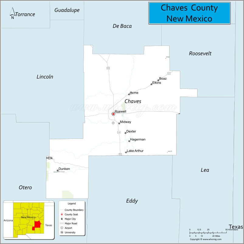
About Chaves County Map, New Mexico: The map showing the county boundary, county seat, major cities, highways, water bodies and neighbouring counties.
Other New Mexico Maps & Info
About Chaves County, New Mexico
Chaves County is a county located in the U.S. state of New Mexico. It's county seat is Roswell. As per 2020 census, the population of Chaves County is 64629 people and population density is square miles. According to the United States Census Bureau, the county has a total area of 6,071 sq mi (15,724 km2). Chaves County was established on 1889.
Chaves County Facts
| Continent | North America |
| Country | United States |
| State | New Mexico |
| County Seat | Roswell |
| Largest City/Town | Roswell |
| Established | 1889 |
| Total Area | 6,075 sq mi (15,734 sq km) |
| Land Area | 6,065 sq mi (15,708 sq km) |
| Water Area | 10 sq mi (26 sq km) |
| Population | 65,157 (Census 2020) |
| Population Density | 10.7 people per sq mi |
| Time Zone | Mountain Time Zone |
| Major Highways | U.S. Highway 70, U.S. Highway 285, U.S. Highway 380, State Road 2, State Road 13 |
| Major Rivers | Pecos River, Rio Hondo |
| Neighboring Counties | De Baca County, Lincoln County, Eddy County, Lea County, Roosevelt County, Otero County |
| Famous For | Roswell UFO history, dairy farming, Pecos Valley agriculture, and aerospace research |
| Top Attractions | International UFO Museum, Bottomless Lakes State Park, Bitter Lake National Wildlife Refuge, and Spring River Park |
| Official Website | Official Website |
About Chaves County, New Mexico
Chaves County is located in southeastern New Mexico and was established in 1889. The county seat is Roswell, which is also the largest city and an important regional center for agriculture, tourism, and aerospace industries. The county features desert plains, river valleys, wildlife refuges, and famous attractions tied to Roswell’s UFO history.
Cities and Towns in Chaves County, New Mexico
| City/Town | Population (Census 2020) | Latitude & Longitude |
|---|---|---|
| Roswell (county seat) | 48,422 | 33.3943°N, 104.5230°W |
| Hagerman | 1,257 | 33.1157°N, 104.3283°W |
| Lake Arthur | 432 | 32.9995°N, 104.3708°W |
| Dexter | 1,037 | 33.1945°N, 104.3738°W |
| Midway (CDP) | 1,054 | 33.4506°N, 104.4308°W |
| North Hobbs (CDP) | 251 | 33.5058°N, 104.4931°W |
| Capitan (partly) | 1,489 | 33.5451°N, 105.5722°W |
Golf Courses in Chaves County, New Mexico
| Golf Course | Location | Latitude & Longitude |
|---|---|---|
| New Mexico Military Institute Golf Course | Roswell | 33.4075°N, 104.5278°W |
| Spring River Golf Course | Roswell | 33.3679°N, 104.4964°W |
| Roswell Country Club | Roswell | 33.3578°N, 104.5150°W |
| Lake Arthur Municipal Golf Course | Lake Arthur | 32.9991°N, 104.3717°W |
Roads and Highways in Chaves County, New Mexico
Major highways connect the county to nearby regions and cities.
- U.S. Highway 70 - major east-west route connecting Roswell with Ruidoso and Las Cruces
- U.S. Highway 285 - north-south highway linking Roswell with Carlsbad and Santa Fe
- U.S. Highway 380 - route connecting Roswell with eastern New Mexico and central regions
- State Road 2 - regional highway serving farming communities in the Pecos Valley
- State Road 13 - connects rural eastern areas of the county
Neighboring Counties of Chaves County
- De Baca County (north)
- Lincoln County (west)
- Otero County (southwest)
- Eddy County (south)
- Lea County (southeast)
- Roosevelt County (east)
Top Attractions in Chaves County, New Mexico
The county offers a mix of natural and cultural attractions.
- International UFO Museum and Research Center - famous Roswell attraction exploring UFO history and exhibits
- Bottomless Lakes State Park - New Mexico’s first state park featuring lakes, camping, and hiking
- Bitter Lake National Wildlife Refuge - birdwatching and wildlife area with wetlands and desert scenery
- Spring River Park and Zoo - family-friendly park with walking trails and animal exhibits
- Walker Aviation Museum - museum dedicated to military and aviation history in Roswell
- Roswell Museum and Art Center - cultural museum featuring regional art and historical exhibits
- New Mexico Military Institute - historic military academy campus in Roswell
- Downtown Roswell - shopping, restaurants, murals, and UFO-themed attractions
- Pecos River Recreation Areas - fishing, boating, and outdoor recreation along the river corridor
- Cahoon Park - community recreation area with sports facilities and playgrounds
- Anderson Museum of Contemporary Art - art museum showcasing modern regional artists
- Dexter National Fish Hatchery - hatchery and wildlife education site near Dexter
Distance from Chaves County to Nearby Cities
The following distances are measured by road (driving).
- Roswell to Albuquerque (Bernalillo County), New Mexico - 205 mi (330 km)
- Roswell to Carlsbad (Eddy County), New Mexico - 76 mi (122 km)
- Roswell to Hobbs (Lea County), New Mexico - 111 mi (179 km)
- Roswell to Clovis (Curry County), New Mexico - 112 mi (180 km)
- Roswell to Ruidoso (Lincoln County), New Mexico - 75 mi (121 km)
- Roswell to Artesia (Eddy County), New Mexico - 42 mi (68 km)
- Roswell to Santa Fe (Santa Fe County), New Mexico - 197 mi (317 km)
- Roswell to Las Cruces (Dona Ana County), New Mexico - 198 mi (319 km)
- Roswell to Amarillo (Potter County), Texas - 217 mi (349 km)
- Roswell to Lubbock (Lubbock County), Texas - 176 mi (283 km)
- Roswell to El Paso (El Paso County), Texas - 202 mi (325 km)
- Roswell to Midland (Midland County), Texas - 222 mi (357 km)
FAQs about Chaves County
Chaves County is located in southeastern New Mexico and includes the city of Roswell.
The population of Chaves County was 65,157 according to the Census 2020.
Chaves County is known for Roswell UFO history, agriculture, dairy farming, and desert recreation areas.
The county is served by U.S. Highway 70, U.S. Highway 285, U.S. Highway 380, and several state roads.
Yes, Chaves County has several golf courses including Spring River Golf Course and Roswell Country Club.
References
- QuickFacts - U.S. Census Bureau
- United States Census Bureau
- United States Geological Survey (USGS)
- National Geodetic Survey
- Official County Website
- Bernalillo County Map
- Catron County Map
- Chaves County Map
- Cibola County Map
- Colfax County Map
- Curry County Map
- De Baca County Map
- Doña Ana County Map
- Eddy County Map
- Grant County Map
- Guadalupe County Map
- Harding County Map
- Hidalgo County Map
- Lea County Map
- Lincoln County Map
- Los Alamos County Map
- Luna County Map
- McKinley County Map
- Mora County Map
- Otero County Map
- Quay County Map
- Rio Arriba County Map
- Roosevelt County Map
- Sandoval County Map
- San Juan County Map
- San Miguel County Map
- Santa Fe County Map
- Sierra County Map
- Socorro County Map
- Taos County Map
- Torrance County Map
- Union County Map
- Valencia County Map
- Alabama Counties
- Alaska boroughs
- Arizona Counties
- Arkansas Counties
- California County Map
- Colorado Counties
- Connecticut Counties
- Delaware Counties
- Florida County Map
- Georgia County Map
- Hawaii Counties
- Idaho Counties
- Illinois Counties
- Indiana Counties
- Iowa Counties
- Kansas Counties
- Kentucky Counties
- Louisiana Counties
- Maine Counties
- Maryland Counties
- Massachusetts Counties
- Michigan County Map
- Minnesota Counties
- Mississippi Counties
- Missouri Counties
- Montana Counties
- Nebraska Counties
- Nevada Counties
- New York Counties
- New Hampshire Counties
- New Jersey Counties
- New Mexico Counties
- North Carolina Counties
- North Dakota Counties
- Ohio County Map
- Oklahoma Counties
- Oregon Counties
- Pennsylvania Counties
- Rhode Island Counties
- South Carolina Counties
- South Dakota Counties
- Map of Tennessee
- Texas County Map
- Utah Counties
- Vermont Counties
- Virginia Counties
- Washington Counties
- West Virginia Counties
- Wisconsin Counties
- Wyoming Counties