
Where is Bernalillo Located? - Bernalillo is a city located in the Sandoval County of New Mexico, United States. Bernalillo lies between 35.32851 Degrees North latitudes and -106.531 Degrees West longitudes.
Location Map of Bernalillo, New Mexico
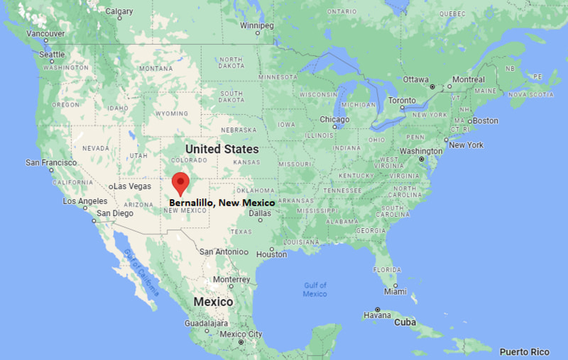
Bernalillo Map, New Mexico, USA
Where is Bernalillo?: The Google Map showing the location of Bernalillo in the U.S. state of New Mexico.
Where is Bernalillo Located?
Bernalillo is a town located in the Sandoval County of New Mexico, United States. Bernalillo lies between 35.32851 Degrees North latitude and -106.531 Degrees West longitude. According to the 2020 U.S. Census, the population of Bernalillo town is 3,218 people and the town has a total area of 4.927 sq mi. The town has numerous parks and recreational facilities.
Most Viewed US Maps
| USA Sttae Map | USA Region Map | USA Road Map |
| USA County Map | Where is USA in World Map? | US ZIP Code Map |
| USA Time Zones Map | US State and Capitals Map | USA Physical Map |
Find 4,400+ U.S. Cities by State - Explore Their Locations and Get Detailed Information
Bernalillo, New Mexico Quick Facts
| Fact | Details |
|---|---|
| Town | Bernalillo |
| County | Sandoval County |
| State | New Mexico |
| State Capital | Santa Fe |
| Country | United States |
| US Region | West |
| Latitude | 35.32851 N |
| Longitude | -106.531 W |
| Elevation | 5,054 ft (1,540 m) |
| Land Area | 4.35 sq mi |
| Water Area | 0.03 sq mi |
| Total Area | 4.927 sq mi |
| Population (Census 2020) | 10,019 |
| Population Density | Approximately 2,300 per sq mi |
| ZIP Code | 87004 |
| Area Code | 505 |
| Time Zone Standard | Mountain Standard Time (MST, UTC-7) |
| Time Zone Daylight | Mountain Daylight Time (MDT, UTC-6) |
| Currency | United States Dollar (USD) |
| FIPS Code | 35-06760 |
| Congressional District | New Mexico's 1st Congressional District |
Nearby Cities and Communities to Bernalillo, New Mexico
- Rio Rancho, New Mexico - 8 mi South
- Corrales, New Mexico - 10 mi South
- Algodones, New Mexico - 11 mi North
- Placitas, New Mexico - 12 mi East
- Albuquerque, New Mexico - 18 mi South
- Los Ranchos de Albuquerque, New Mexico - 17 mi South
- North Valley, New Mexico - 18 mi South
- Santa Ana Pueblo, New Mexico - 3 mi North
- Jemez Pueblo, New Mexico - 38 mi Northwest
- Santa Fe, New Mexico - 52 mi Northeast
Bernalillo, New Mexico Climate and Weather Overview
| Month | Avg High (°F) | Avg Low (°F) | Avg Rainfall (in) |
|---|---|---|---|
| January | 48 | 24 | 0.5 |
| April | 69 | 39 | 0.4 |
| July | 92 | 66 | 1.7 |
| October | 72 | 43 | 0.9 |
| Annual | 71 | 43 | 9.2 |
| Climate Attribute | Details |
|---|---|
| Climate Classification | Cold Semi-Arid (Köppen BSk) |
| Annual Rainfall | Approximately 9 inches |
| Annual Sunshine Days | About 280 days |
| Hurricane/Tornado Risk | Very Low - Occasional summer thunderstorms and flash flooding |
| Snowfall | Approximately 8 inches annually |
Driving Distances from Bernalillo, New Mexico
| City | State | Distance (mi) | Approx. Drive Time |
|---|---|---|---|
| Santa Ana Pueblo | New Mexico | 3 | 5 min |
| Rio Rancho | New Mexico | 8 | 12 min |
| Corrales | New Mexico | 10 | 15 min |
| Algodones | New Mexico | 11 | 15 min |
| Placitas | New Mexico | 12 | 18 min |
| Albuquerque | New Mexico | 18 | 25 min |
| Los Ranchos de Albuquerque | New Mexico | 17 | 25 min |
| North Valley | New Mexico | 18 | 25 min |
| Jemez Pueblo | New Mexico | 38 | 45 min |
| Santa Fe | New Mexico | 52 | 55 min |
Transportation and Connectivity in Bernalillo, New Mexico
| Transportation | Details |
|---|---|
| Airport Name | Albuquerque International Sunport (nearest major airport) |
| IATA Code | ABQ |
| Port | Not Applicable |
| Major Highways | Interstate 25, U.S. Highway 550, New Mexico State Road 313 |
| Train/Amtrak Service | New Mexico Rail Runner Express station in Downtown Bernalillo |
| Local Bus/Transit Service | Rio Metro Regional Transit District |
- Interstate 25 - The primary north-south highway connecting Bernalillo with Albuquerque, Santa Fe and Las Cruces.
- U.S. Highway 550 - Provides access to northwestern New Mexico, Farmington and connections toward Colorado.
- New Mexico Rail Runner Express - Commuter rail service offering convenient travel between Belen, Albuquerque, Bernalillo and Santa Fe.
- Albuquerque International Sunport - The nearest major commercial airport, located about 25 miles south of Bernalillo.
Key Landmarks and Places to Visit in Bernalillo, New Mexico
| Landmark | Type |
|---|---|
| Coronado Historic Site | State Historic Site |
| Santa Ana Star Casino Hotel | Casino and Resort |
| Santa Ana Golf Club | Golf Course |
| Jemez Historic Site | Historic Pueblo Ruins |
| Rio Grande Bosque | Nature Area |
| Sandia Peak Tramway | Scenic Attraction |
| Placitas Artists Series | Cultural Venue |
| Santa Ana Pueblo | Native American Pueblo |
| Cabezon Peak | Natural Landmark |
| Balloon Fiesta Park | Event Venue |
Colleges and Universities in Bernalillo, New Mexico
| Institution | Type | Level | Notable For |
|---|---|---|---|
| University of New Mexico | Public | University | Research, medicine and engineering |
| Central New Mexico Community College | Public | Community College | Career and technical education |
| Sandoval Sign Language Academy | Public | Specialized Education | Deaf education programs |
| Southwestern Indian Polytechnic Institute | Federal | College | STEM and Native American education |
| Santa Fe Community College | Public | Community College | Transfer and workforce programs |
| New Mexico Highlands University - Rio Rancho Center | Public | University Center | Graduate and professional programs |
Waterbodies in Bernalillo, New Mexico
Rio Grande, Jemez River, Cochiti Lake, Angostura Diversion Dam, Rio Jemez, Sandia Lakes, Tingley Beach ponds, Elephant Butte Reservoir, Bluewater Lake, Abiquiu Lake.
Golf Courses in Bernalillo, New Mexico
Santa Ana Golf Club, Twin Warriors Golf Club, Sandia Golf Club, Paradise Hills Golf Club, Albuquerque Country Club, University of New Mexico Championship Golf Course, Paako Ridge Golf Club, Cochiti Golf Club.
Bernalillo, New Mexico - Key Historical Facts
- Bernalillo was founded in 1695 by Spanish settlers after earlier settlements along the Rio Grande and is one of New Mexico's oldest communities.
- The town developed as an important agricultural and trading center along the historic El Camino Real de Tierra Adentro, connecting Mexico City with northern New Mexico.
- Nearby Coronado Historic Site preserves the ruins of the Kuaua Pueblo, where Spanish explorer Francisco Vázquez de Coronado visited during his expedition in 1540.
- For centuries, Bernalillo has maintained strong Hispanic and Native American cultural traditions that continue to shape local festivals, architecture and cuisine.
- The arrival of rail transportation and later Interstate 25 strengthened Bernalillo's role as a gateway between Albuquerque and Santa Fe.
- Today, Bernalillo is known for its rich history, cultural heritage, nearby pueblos, outdoor recreation and scenic setting along the Rio Grande.
References
New Mexico Maps & Info
- Where is Alamogordo
- Where is Artesia
- Where is Aztec
- Where is Belen
- Where is Bernalillo
- Where is Bloomfield
- Where is Bosque Farms
- Where is Carlsbad
- Where is Chaparral
- Where is Clovis
- Where is Corrales
- Where is Deming
- Where is Edgewood
- Where is El Cerro Mission
- Where is Eldorado at Santa Fe
- Where is Farmington
- Where is Gallup
- Where is Grants
- Where is Hobbs
- Where is Holloman AFB
- Where is Las Cruces
- Where is Los Alamos
- Where is Los Chaves
- Where is Los Lunas
- Where is Los Ranchos de Albuquerque
- Where is Lovington
- Where is Meadow Lake
- Where is North Hobbs
- Where is North Valley
- Where is Paradise Hills
- Where is Placitas
- Where is Portales
- Where is Raton
- Where is Rio Rancho
- Where is Roswell
- Where is Ruidoso
- Where is Santa Fe
- Where is Santa Teresa
- Where is Shiprock
- Where is Silver City
- Where is Socorro
- Where is South Valley
- Where is Sunland Park
- Where is Taos
- Where is Truth or Consequences
- Where is Tucumcari
- Where is White Rock
- Where is Zuni Pueblo