
Where is Grants Located? - Grants is a city located in the Cibola County of New Mexico, United States. Grants lies between 34.1014873 Degrees North latitudes and 84.5193754 Degrees West longitudes.
Location Map of Grants, New Mexico
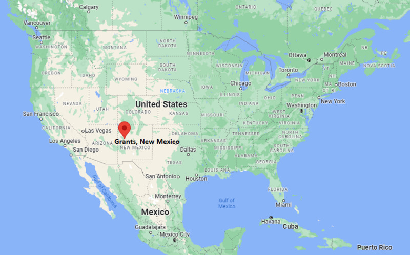
Grants Map, New Mexico, USA
Where is Grants?: The Google Map showing the location of Grants in the U.S. state of New Mexico.
Where is Grants Located?
Grants is a city located in the Cibola County of New Mexico, United States. Grants lies between 34.1014873 Degrees North latitudes and 84.5193754 Degrees West longitudes. According to 2020 U.S.census, the population of Grants city is 9163 people and the city has a total area of 14.91 sq mi. The city has numerous parks and recreational facilities.
Most Viewed US Maps
| USA Sttae Map | USA Region Map | USA Road Map |
| USA County Map | Where is USA in World Map? | US ZIP Code Map |
| USA Time Zones Map | US State and Capitals Map | USA Physical Map |
Find 4,400+ U.S. Cities by State - Explore Their Locations and Get Detailed Information
Grants, New Mexico Quick Facts
| Property | Information |
|---|---|
| City | Grants |
| County | Cibola County |
| State | New Mexico |
| State Capital | Santa Fe |
| US Region | Western United States |
| Latitude | 35.1473°N |
| Longitude | 107.8526°W |
| Elevation | 6,460 ft (1,969 m) |
| Land Area | 14.28 sq mi |
| Water Area | 0.00 sq mi |
| Total Area | 14.28 sq mi |
| Population (latest Census year) | 9,163 (Census 2020) |
| Population Density (per sq mi) | Approximately 642 |
| ZIP Code | 87020 |
| Area Code | 505 |
| Time Zone Standard | Mountain Standard Time (MST, UTC−7) |
| Time Zone Daylight | Mountain Daylight Time (MDT, UTC−6) |
| Currency | United States Dollar (USD) |
| FIPS Code | 35-30220 |
| Congressional District | New Mexico's 2nd Congressional District |
Nearby Cities to Grants, New Mexico
- Milan, New Mexico — 4 mi East
- San Rafael, New Mexico — 10 mi Southwest
- Acoma Pueblo, New Mexico — 25 mi Southeast
- Gallup, New Mexico — 40 mi West
- Albuquerque, New Mexico — 80 mi East
- Los Lunas, New Mexico — 105 mi East
- Socorro, New Mexico — 120 mi Southeast
- Santa Fe, New Mexico — 155 mi Northeast
- Flagstaff, Arizona — 190 mi West
- Farmington, New Mexico — 180 mi Northwest
Driving Distances from Grants, New Mexico
| City | State | Distance (mi) | Approx. Drive Time |
|---|---|---|---|
| Milan | New Mexico | 4 | 10 minutes |
| San Rafael | New Mexico | 10 | 15 minutes |
| Acoma Pueblo | New Mexico | 25 | 35 minutes |
| Gallup | New Mexico | 40 | 40 minutes |
| Albuquerque | New Mexico | 80 | 1 hour 15 minutes |
| Los Lunas | New Mexico | 105 | 1 hour 40 minutes |
| Socorro | New Mexico | 120 | 2 hours |
| Santa Fe | New Mexico | 155 | 2 hours 45 minutes |
| Farmington | New Mexico | 180 | 3 hours |
| Flagstaff | Arizona | 190 | 3 hours |
Transportation and Connectivity in Grants, New Mexico
| Transportation | Details |
|---|---|
| Airport Name | Grants-Milan Municipal Airport |
| IATA Code | GNT |
| Port | Not Applicable |
| Major Highways | Interstate 40, U.S. Route 66, New Mexico State Road 53 |
| Train/Amtrak Service | Nearest Amtrak service available in Albuquerque |
| Local Bus/Transit Service | Regional transportation services available |
- Interstate 40 - Major east-west interstate connecting Grants with Albuquerque, Gallup, and Arizona.
- Historic U.S. Route 66 - Famous highway passing through Grants and western New Mexico communities.
- New Mexico State Road 53 - Scenic route connecting Grants with El Malpais National Monument.
What are top Places to Visit in Grants, New Mexico
| Landmark Name | Type |
|---|---|
| El Malpais National Monument | National Monument |
| El Morro National Monument | National Monument |
| New Mexico Mining Museum | Museum |
| Mount Taylor | Mountain Landmark |
| Bluewater Lake State Park | State Park |
| Ice Cave and Bandera Volcano | Natural Attraction |
| Cibola National Forest | Forest Area |
| Route 66 Neon Drive-Thru Sign | Historic Attraction |
| El Malpais Ranger Station | Visitor Center |
| Chaco Culture National Historical Park | Historical Park |
Colleges and Universities near Grants, New Mexico
| Institution Name | Type | Level | Notable For |
|---|---|---|---|
| University of New Mexico - Grants Campus | Public | Branch Campus | Associate degrees, workforce training, and community education |
| University of New Mexico | Public | University | Research, medicine, engineering, and liberal arts programs |
| Central New Mexico Community College | Public | Community College | Technical education, career programs, and workforce development |
| New Mexico State University - Grants Programs | Public | Higher Education Programs | Extension and community education services |
| Grants-Cibola County Schools | Public | K–12 District | Public education services |
Waterbodies in Grants, New Mexico
Bluewater Lake, San Jose River, Rio San Jose, Bluewater Creek, Zuni River (nearby)
Golf Courses near Grants, New Mexico
Coyote del Malpais Golf Course, Grants Golf Course, El Malpais Golf Course, Cibola County golf facilities
Grants, New Mexico — Key Historical Facts
- Grants was founded in the late nineteenth century as a railroad and logging community.
- The city was named after the Grants brothers, Canadian railroad contractors who helped build a section of the Atlantic and Pacific Railroad through the area.
- The arrival of the railroad in the 1880s helped establish Grants as an important transportation and trade center in western New Mexico.
- The region became nationally known for uranium mining during the mid-twentieth century, earning the nickname "Uranium Capital of the World."
- Grants played an important role in the development of uranium mining operations that supported the United States nuclear industry.
- The surrounding area has deep Native American history, including connections to the Acoma, Laguna, and Zuni peoples.
- Today, Grants is known for its Route 66 heritage, mining history, outdoor recreation, and access to volcanic landscapes and national monuments.
References
New Mexico Maps & Info
- Where is Alamogordo
- Where is Artesia
- Where is Aztec
- Where is Belen
- Where is Bernalillo
- Where is Bloomfield
- Where is Bosque Farms
- Where is Carlsbad
- Where is Chaparral
- Where is Clovis
- Where is Corrales
- Where is Deming
- Where is Edgewood
- Where is El Cerro Mission
- Where is Eldorado at Santa Fe
- Where is Farmington
- Where is Gallup
- Where is Grants
- Where is Hobbs
- Where is Holloman AFB
- Where is Las Cruces
- Where is Los Alamos
- Where is Los Chaves
- Where is Los Lunas
- Where is Los Ranchos de Albuquerque
- Where is Lovington
- Where is Meadow Lake
- Where is North Hobbs
- Where is North Valley
- Where is Paradise Hills
- Where is Placitas
- Where is Portales
- Where is Raton
- Where is Rio Rancho
- Where is Roswell
- Where is Ruidoso
- Where is Santa Fe
- Where is Santa Teresa
- Where is Shiprock
- Where is Silver City
- Where is Socorro
- Where is South Valley
- Where is Sunland Park
- Where is Taos
- Where is Truth or Consequences
- Where is Tucumcari
- Where is White Rock
- Where is Zuni Pueblo