
Where is Farmington Located? - Farmington is a city located in the San Juan County of New Mexico, United States. Farmington lies between 41.278637 Degrees North latitudes and 73.0265277 Degrees West longitudes.
Location Map of Farmington, New Mexico
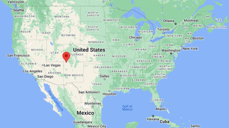
Farmington Map, New Mexico, USA
Where is Farmington?: The Google Map showing the location of Farmington in the U.S. state of New Mexico.
Where is Farmington Located?
Farmington is a city located in the San Juan County of New Mexico, United States. Farmington lies between 41.278637 Degrees North latitudes and 73.0265277 Degrees West longitudes. According to 2020 U.S.census, the population of Farmington city is 46624 people and the city has a total area of 34.46 sq mi. The city has numerous parks and recreational facilities.
Most Viewed US Maps
| USA Sttae Map | USA Region Map | USA Road Map |
| USA County Map | Where is USA in World Map? | US ZIP Code Map |
| USA Time Zones Map | US State and Capitals Map | USA Physical Map |
Find 4,400+ U.S. Cities by State - Explore Their Locations and Get Detailed Information
Farmington, New Mexico Quick Facts
| Property | Information |
|---|---|
| City | Farmington |
| County | San Juan County |
| State | New Mexico |
| State Capital | Santa Fe |
| US Region | Western United States |
| Latitude | 36.7281° N |
| Longitude | 108.2187° W |
| Elevation | 5,395 ft (1,644 m) |
| Land Area | 38.73 sq mi |
| Water Area | 0.22 sq mi |
| Total Area | 38.95 sq mi |
| Population (latest Census year) | 46,624 (2020 Census) |
| Population Density | 1,204 per sq mi |
| ZIP Codes | 87401, 87402, 87499 |
| Area Code | 505 |
| Time Zone Standard | Mountain Standard Time (MST, UTC−7) |
| Time Zone Daylight | Mountain Daylight Time (MDT, UTC−6) |
| Currency | US Dollar (USD) |
| FIPS Code | 35-25870 |
| Congressional District | 2nd Congressional District |
Nearby Cities to Farmington, New Mexico
- Aztec, New Mexico — 13 mi Northeast
- Bloomfield, New Mexico — 14 mi East
- Kirtland, New Mexico — 9 mi Southwest
- Shiprock, New Mexico — 28 mi West
- Cortez, Colorado — 44 mi Northwest
- Durango, Colorado — 48 mi North
- Gallup, New Mexico — 92 mi South
- Pagosa Springs, Colorado — 104 mi Northeast
- Grants, New Mexico — 139 mi Southeast
- Monticello, Utah — 81 mi Northwest
Driving Distances from Farmington, New Mexico
| City | State | Distance (mi) | Approx. Drive Time |
|---|---|---|---|
| Kirtland | New Mexico | 9 | 12 min |
| Aztec | New Mexico | 13 | 18 min |
| Bloomfield | New Mexico | 14 | 20 min |
| Shiprock | New Mexico | 28 | 35 min |
| Cortez | Colorado | 44 | 55 min |
| Durango | Colorado | 48 | 1 hr |
| Gallup | New Mexico | 92 | 1 hr 35 min |
| Monticello | Utah | 81 | 1 hr 30 min |
| Pagosa Springs | Colorado | 104 | 2 hr |
| Santa Fe | New Mexico | 180 | 3 hr |
Transportation and Connectivity in Farmington, New Mexico
| Category | Information |
|---|---|
| Airport Name | Four Corners Regional Airport |
| IATA Code | FMN |
| Port | Not applicable |
| Major Highways | US Route 64, US Route 491, New Mexico State Road 371, New Mexico State Road 516 |
| Train/Amtrak Service | No passenger rail service; nearest Amtrak station is Gallup |
| Local Bus/Transit Service | Red Apple Transit |
- US Route 64 - Major east-west highway connecting Farmington with Bloomfield, Shiprock, Taos and Arizona.
- US Route 491 - North-south highway linking the city with Gallup, Cortez and southwestern Colorado.
- New Mexico State Road 371 - Scenic route providing access to Crownpoint and central New Mexico.
- New Mexico State Road 516 - Important arterial serving western Farmington and nearby residential and commercial districts.
What are top Places to Visit in Farmington, New Mexico
| Landmark Name | Type |
|---|---|
| Riverside Nature Center | Nature Center |
| Berg Park | City Park |
| E3 Children's Museum & Science Center | Museum |
| Farmington Museum at Gateway Park | Museum |
| Animas Park | Park |
| Lake Farmington | Recreation Area |
| Salmon Ruins Museum | Archaeological Museum |
| Aztec Ruins National Monument | National Monument |
| Chaco Culture National Historical Park | Historical Park |
| Bisti/De-Na-Zin Wilderness | Natural Attraction |
Colleges and Universities in Farmington, New Mexico
| Institution Name | Type | Level | Notable For |
|---|---|---|---|
| San Juan College | Public | Community College | Technical, health sciences and workforce education |
| University of New Mexico – Farmington | Public | University | Bachelor's and graduate degree programs |
| New Mexico Highlands University – Farmington Center | Public | University | Teacher education and graduate studies |
| Farmington Municipal Schools | Public | K–12 District | Comprehensive public education |
Waterbodies in Farmington, New Mexico
San Juan River, Animas River, La Plata River, Navajo Lake, Morgan Lake, Lake Farmington, Chokecherry Canyon Reservoir, Largo Wash
Golf Courses in Farmington, New Mexico
Pinon Hills Golf Course, Civitan Golf Course, Riverview Golf Course, San Juan Country Club, Bloomfield Golf Course
Farmington, New Mexico — Key Historical Facts
- Farmington was founded in 1901 where the Animas and San Juan rivers meet, making it an important agricultural and trading center.
- The discovery of oil and natural gas in the San Juan Basin during the twentieth century transformed the city's economy and fueled rapid growth.
- Farmington became a regional hub for energy production, serving the Four Corners area with mining, natural gas, and power generation industries.
- Its location near Chaco Culture National Historical Park, Aztec Ruins National Monument, and other archaeological sites has strengthened the city's tourism industry.
- Today, Farmington is the commercial, healthcare, educational, and cultural center of northwestern New Mexico, serving residents across the Four Corners region.
References
New Mexico Maps & Info
- Where is Alamogordo
- Where is Artesia
- Where is Aztec
- Where is Belen
- Where is Bernalillo
- Where is Bloomfield
- Where is Bosque Farms
- Where is Carlsbad
- Where is Chaparral
- Where is Clovis
- Where is Corrales
- Where is Deming
- Where is Edgewood
- Where is El Cerro Mission
- Where is Eldorado at Santa Fe
- Where is Farmington
- Where is Gallup
- Where is Grants
- Where is Hobbs
- Where is Holloman AFB
- Where is Las Cruces
- Where is Los Alamos
- Where is Los Chaves
- Where is Los Lunas
- Where is Los Ranchos de Albuquerque
- Where is Lovington
- Where is Meadow Lake
- Where is North Hobbs
- Where is North Valley
- Where is Paradise Hills
- Where is Placitas
- Where is Portales
- Where is Raton
- Where is Rio Rancho
- Where is Roswell
- Where is Ruidoso
- Where is Santa Fe
- Where is Santa Teresa
- Where is Shiprock
- Where is Silver City
- Where is Socorro
- Where is South Valley
- Where is Sunland Park
- Where is Taos
- Where is Truth or Consequences
- Where is Tucumcari
- Where is White Rock
- Where is Zuni Pueblo