
Where is Evanston Located? - Evanston is a city located in the Uinta County of Wyoming, United States. Evanston lies between 47.1553769 Degrees North latitudes and 122.4340113 Degrees West longitudes.
Location Map of Evanston, Wyoming
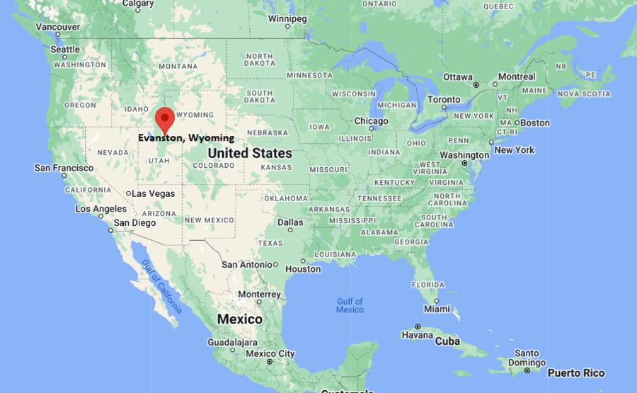
Evanston Map, Wyoming, USA
Where is Evanston?: The Google Map showing the location of Evanston in the U.S. state of Wyoming.
Where is Evanston Located?
Evanston is a city located in the Uinta County of Wyoming, United States. Evanston lies between 47.1553769 Degrees North latitudes and 122.4340113 Degrees West longitudes. According to 2020 U.S.census, the population of Evanston city is 11747 people and the city has a total area of 10.29 sq mi. The city has numerous parks and recreational facilities.
Most Viewed US Maps
| USA Sttae Map | USA Region Map | USA Road Map |
| USA County Map | Where is USA in World Map? | US ZIP Code Map |
| USA Time Zones Map | US State and Capitals Map | USA Physical Map |
Find 4,400+ U.S. Cities by State - Explore Their Locations and Get Detailed Information
Evanston, Wyoming Quick Facts
| Property | Details |
|---|---|
| City | Evanston |
| County | Uinta County |
| State | Wyoming |
| State Capital | Cheyenne |
| US Region | West |
| Latitude | 41.2683°N |
| Longitude | 110.9632°W |
| Elevation | ~6,749 ft (2,057 m) |
| Land Area | Approx. 9.5 sq mi |
| Water Area | Approx. 0.1 sq mi |
| Total Area | Approx. 9.6 sq mi |
| Population (2020 Census) | ~11,500 |
| Population Density | Approximately 1,200 per sq mi |
| ZIP Codes | 82930 |
| Area Code | 307 |
| Time Zone Standard | Mountain Standard Time (MST), UTC−7 |
| Time Zone Daylight | Mountain Daylight Time (MDT), UTC−6 |
| Currency | US Dollar (USD) |
| FIPS Code | 56-25620 |
| Congressional District | Wyoming At-Large District |
Nearby Cities to Evanston, Wyoming
- Bear River, Wyoming - West - 15 mi
- Mountain View, Wyoming - North - 30 mi
- Fort Bridger, Wyoming - East - 20 mi
- Granger, Wyoming - Northeast - 55 mi
- Green River, Wyoming - North - 65 mi
- Rock Springs, Wyoming - North - 70 mi
- Salt Lake City, Utah - Southwest - 85 mi
- Park City, Utah - Southwest - 110 mi
- Logan, Utah - West - 80 mi
- Ogden, Utah - Southwest - 120 mi
Evanston, Wyoming Climate and Weather Overview
| Month | Avg High (°F) | Avg Low (°F) | Avg Rainfall (in) |
|---|---|---|---|
| January | 31 | 6 | 0.8 |
| April | 55 | 25 | 1.2 |
| July | 86 | 48 | 0.6 |
| October | 60 | 28 | 0.9 |
| Annual | 55 | 25 | ~10.5 |
| Climate Attribute | Details |
|---|---|
| Climate Classification (Köppen) | Cold semi-arid (BSk) |
| Annual Rainfall | About 10–11 inches |
| Summer Conditions | Warm days, cool nights |
| Winter Conditions | Cold, snowy, and dry |
| Severe Weather Risk | Blizzards, high winds, cold snaps |
Driving Distances from Evanston, Wyoming
| City | State | Distance (mi) | Approx. Drive Time |
|---|---|---|---|
| Bear River | Wyoming | 15 | 20 min |
| Fort Bridger | Wyoming | 20 | 25 min |
| Mountain View | Wyoming | 30 | 35 min |
| Green River | Wyoming | 65 | 1 hr 10 min |
| Rock Springs | Wyoming | 70 | 1 hr 15 min |
| Logan | Utah | 80 | 1 hr 30 min |
| Salt Lake City | Utah | 85 | 1 hr 15–1 hr 30 min |
| Ogden | Utah | 120 | 2 hr |
| Park City | Utah | 110 | 2 hr |
| Cheyenne | Wyoming | 330 | 4 hr 45 min |
Transportation and Connectivity in Evanston, Wyoming
| Transportation | Details |
|---|---|
| Airport Name | Evanston-Uinta County Airport – Burns Field |
| IATA Code | EVW |
| Major Highways | Interstate 80, U.S. Route 189 |
| Rail Service | Union Pacific Railroad (freight only) |
| Nearest Major Airport | Salt Lake City International Airport (SLC) |
| Local Transit | Limited municipal transit services |
- Evanston is located in southwestern Wyoming near the Utah border.
- It serves as a historic railroad town along the Union Pacific line.
- The city sits at high elevation, resulting in colder winters and mild summers.
- Interstate 80 makes it an important east–west transportation corridor.
Places to Visit in Evanston, Wyoming
| Landmark Name | Type |
|---|---|
| Bear River State Park | State Park |
| Historic Downtown Evanston | Historic District |
| Uinta County Museum | Museum |
| Chinese Joss House Museum | Historic Site |
| Hilliard State Wildlife Area | Wildlife Area |
| Roundhouse and Railyards | Historic Railroad Site |
| Yellow Creek Campground | Recreation Area |
| Bear River Greenway | Scenic Trail |
| Fort Bridger Historic Site | Historic Site |
| Wasatch-Cache National Forest (nearby) | National Forest |
Colleges and Universities in Evanston, Wyoming
| Institution Name | Type | Level | Notable For |
|---|---|---|---|
| Western Wyoming Community College (regional access) | Public | Community College | Technical training and associate degrees |
| University of Wyoming (regional access) | Public | University | Engineering, agriculture, research |
| Utah State University (regional access) | Public | University | Science, business, agriculture |
| Bridger Valley Education Programs | Public | K–12 District | Local primary and secondary education |
| Uinta County School District #1 | Public | K–12 District | Public schooling system |
| Rock Springs Education Centers (regional) | Public | Education Network | Vocational and adult education |
| Salt Lake City Metro Colleges (regional access) | Public/Private | University Network | Higher education options nearby |
| Wyoming Technical Institute (regional access) | Private | Technical College | Career and technical training |
Waterbodies in Evanston, Wyoming
Bear River, Weber River (nearby), Smiths Fork River, Yellow Creek, Bear River Reservoir system, Sulphur Creek, Hams Fork River (regional), Green River (regional watershed)
Golf Courses in Evanston, Wyoming
Evanston Golf Club, Purple Sage Golf Course, Bear Lake Golf Course (regional), Mountain View Golf Course, Bridger Valley Golf Course, Rock Springs Golf Club (regional), Logan River Golf Course, Glen Eagle Golf Course (Utah regional access)
Evanston, Wyoming — Key Historical Facts
- Evanston was established in the late 1800s as a key stop on the Union Pacific Railroad.
- The city grew rapidly due to its role in railroad maintenance and operations.
- It became known for its historic roundhouse and rail yard facilities.
- Chinese immigrant workers played an important role in early railroad development.
- Oil, gas, and transportation industries later contributed to the local economy.
- Today, Evanston preserves its railroad heritage while serving as a regional service hub.
References
Wyoming Maps and Info
| Wyoming Map | Counties in Wyoming | Cities in Wyoming |
| Wyoming Zipcodes | Airports in Wyoming | US Zip code Map |
| Wyoming Area Codes | Wyoming River Map | - |
- Where is Afton
- Where is Alpine
- Where is Arapahoe
- Where is Bar Nunn
- Where is Basin
- Where is Casper
- Where is Cheyenne
- Where is Cody
- Where is Douglas
- Where is Ethete
- Where is Evanston
- Where is Evansville
- Where is Fort Washakie
- Where is Fox Farm-College
- Where is Gillette
- Where is Glenrock
- Where is Green River
- Where is Greybull
- Where is Hoback
- Where is Jackson
- Where is Kemmerer
- Where is Lander
- Where is Laramie
- Where is Lovell
- Where is Lusk
- Where is Lyman
- Where is Mills
- Where is Moose Wilson Road
- Where is Mountain View
- Where is Newcastle
- Where is North Rock Springs
- Where is Pinedale
- Where is Powell
- Where is Ranchettes
- Where is Rawlins
- Where is Riverton
- Where is Rock Springs
- Where is Saratoga
- Where is Sheridan
- Where is South Greeley
- Where is South Park
- Where is Star Valley Ranch
- Where is Thermopolis
- Where is Torrington
- Where is Warren AFB
- Where is Wheatland
- Where is Wilson
- Where is Worland
- Where is Wright