
Where is Evansville Located? - Evansville is a city located in the Natrona County of Wyoming, United States. Evansville lies between 47.0962112 Degrees North latitudes and 122.3587307 Degrees West longitudes.
Location Map of Evansville, Wyoming
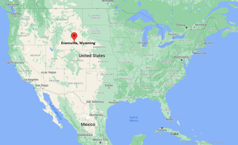
Evansville Map, Wyoming, USA
Where is Evansville?: The Google Map showing the location of Evansville in the U.S. state of Wyoming.
Where is Evansville Located?
Evansville is a city located in the Natrona County of Wyoming, United States. Evansville lies between 47.0962112 Degrees North latitudes and 122.3587307 Degrees West longitudes. According to 2020 U.S.census, the population of Evansville city is 2746 people and the city has a total area of 3.46 sq mi. The city has numerous parks and recreational facilities.
Most Viewed US Maps
| USA Sttae Map | USA Region Map | USA Road Map |
| USA County Map | Where is USA in World Map? | US ZIP Code Map |
| USA Time Zones Map | US State and Capitals Map | USA Physical Map |
Find 4,400+ U.S. Cities by State - Explore Their Locations and Get Detailed Information
Evansville, Wyoming Quick Facts
| Property | Details |
|---|---|
| City | Evansville |
| County | Natrona County |
| State | Wyoming |
| State Capital | Cheyenne |
| US Region | West |
| Latitude | 42.8616°N |
| Longitude | 106.2689°W |
| Elevation | ~5,150 ft (1,570 m) |
| Land Area | Approx. 1.5 sq mi |
| Water Area | Approx. 0.0 sq mi |
| Total Area | Approx. 1.5 sq mi |
| Population (2020 Census) | ~2,500 |
| Population Density | Approximately 1,600 per sq mi |
| ZIP Codes | 82636 |
| Area Code | 307 |
| Time Zone Standard | Mountain Standard Time (MST), UTC−7 |
| Time Zone Daylight | Mountain Daylight Time (MDT), UTC−6 |
| Currency | US Dollar (USD) |
| FIPS Code | 56-24835 |
| Congressional District | Wyoming At-Large District |
Nearby Cities to Evansville, Wyoming
- Casper, Wyoming - West - 6 mi
- Bar Nunn, Wyoming - Northwest - 5 mi
- Midwest, Wyoming - North - 45 mi
- Mills, Wyoming - West - 4 mi
- Douglas, Wyoming - Northeast - 90 mi
- Glenrock, Wyoming - East - 25 mi
- Shoshoni, Wyoming - Northwest - 55 mi
- Riverton, Wyoming - Northwest - 115 mi
- Lander, Wyoming - Northwest - 140 mi
- Cheyenne, Wyoming - Southeast - 180 mi
Evansville, Wyoming Climate and Weather Overview
| Month | Avg High (°F) | Avg Low (°F) | Avg Rainfall (in) |
|---|---|---|---|
| January | 33 | 12 | 0.5 |
| April | 56 | 28 | 1.0 |
| July | 88 | 56 | 0.9 |
| October | 62 | 32 | 0.8 |
| Annual | 58 | 30 | ~12.5 |
| Climate Attribute | Details |
|---|---|
| Climate Classification (Köppen) | Cold semi-arid (BSk) |
| Annual Rainfall | About 12–13 inches |
| Summer Conditions | Warm days, cool nights |
| Winter Conditions | Cold, dry, and snowy |
| Severe Weather Risk | High winds, snowstorms, occasional hail |
Driving Distances from Evansville, Wyoming
| City | State | Distance (mi) | Approx. Drive Time |
|---|---|---|---|
| Casper | Wyoming | 6 | 10–12 min |
| Mills | Wyoming | 4 | 8 min |
| Bar Nunn | Wyoming | 5 | 10 min |
| Glenrock | Wyoming | 25 | 25–30 min |
| Shoshoni | Wyoming | 55 | 55 min |
| Douglas | Wyoming | 90 | 1 hr 20 min |
| Riverton | Wyoming | 115 | 2 hr |
| Lander | Wyoming | 140 | 2 hr 20 min |
| Cheyenne | Wyoming | 180 | 2 hr 50 min |
| Billings | Montana | 190 | 3 hr |
Transportation and Connectivity in Evansville, Wyoming
| Transportation | Details |
|---|---|
| Airport Name | Casper–Natrona County International Airport |
| IATA Code | CPR |
| Major Highways | US-20/26, US-87, Wyoming Blvd access routes |
| Rail Service | Freight rail (no passenger service) |
| Nearest Major Airport | Denver International Airport (DEN) |
| Local Transit | Casper Area Transit (regional access) |
- Evansville is a small community just east of Casper in central Wyoming.
- It is part of the Casper metropolitan area and closely tied to its economy.
- The area developed along early highway and oil industry routes.
- Today it functions primarily as a residential suburb.
Places to Visit in Evansville, Wyoming
| Landmark Name | Type |
|---|---|
| Casper Mountain Recreation Area | Outdoor Recreation Area |
| Fort Caspar Museum | Historic Site & Museum |
| National Historic Trails Interpretive Center | Museum |
| Garden Creek Falls | Natural Landmark |
| Edness K. Wilkins State Park | State Park |
| Casper Events Center | Event Arena |
| Three Crowns Golf Club | Golf Course |
| Casper Country Club | Golf Course |
| Beartrap Meadow | Outdoor Recreation Area |
| North Platte River Greenway | River Trail |
Colleges and Universities in Evansville, Wyoming
| Institution Name | Type | Level | Notable For |
|---|---|---|---|
| Casper College | Public | Community College | Technical programs, associate degrees, nursing |
| University of Wyoming (regional access) | Public | University | Engineering, agriculture, research |
| Wyoming Technical Institute (WyoTech) | Private | Technical College | Automotive and technical training |
| Central Wyoming College (regional access) | Public | Community College | Workforce training and transfer programs |
| Natrona County School District | Public | K–12 District | Primary and secondary education |
| Casper Area Educational Programs | Public | Education Network | Adult education and vocational training |
| Western Wyoming Community College (regional) | Public | Community College | Regional higher education access |
| Wyoming Online Learning Network | Public | Education System | Statewide distance learning |
Waterbodies in Evansville, Wyoming
North Platte River, Garden Creek, Casper Creek, Hat Six Creek, Alcova Reservoir (regional), Pathfinder Reservoir (regional), Sweetwater River (regional), Hogadon Basin streams
Golf Courses in Evansville, Wyoming
Three Crowns Golf Club, Casper Country Club, Paradise Valley Golf Course, Oregon Trail Golf Course, Alcova Lake Golf Area (regional recreation access), Brookhurst Golf Course, Rolling Green Country Club (regional), Douglas Golf Course (regional)
Evansville, Wyoming — Key Historical Facts
- Evansville developed as a residential community alongside the growth of nearby Casper.
- The region’s early economy was shaped by oil, gas, and railroad expansion.
- Its location along transportation corridors helped connect it to central Wyoming trade routes.
- Casper’s industrial growth strongly influenced Evansville’s suburban development.
- The North Platte River valley played an important role in early settlement patterns.
- Today, Evansville functions primarily as a small suburban community within the Casper metro area.
References
Wyoming Maps and Info
| Wyoming Map | Counties in Wyoming | Cities in Wyoming |
| Wyoming Zipcodes | Airports in Wyoming | US Zip code Map |
| Wyoming Area Codes | Wyoming River Map | - |
- Where is Afton
- Where is Alpine
- Where is Arapahoe
- Where is Bar Nunn
- Where is Basin
- Where is Casper
- Where is Cheyenne
- Where is Cody
- Where is Douglas
- Where is Ethete
- Where is Evanston
- Where is Evansville
- Where is Fort Washakie
- Where is Fox Farm-College
- Where is Gillette
- Where is Glenrock
- Where is Green River
- Where is Greybull
- Where is Hoback
- Where is Jackson
- Where is Kemmerer
- Where is Lander
- Where is Laramie
- Where is Lovell
- Where is Lusk
- Where is Lyman
- Where is Mills
- Where is Moose Wilson Road
- Where is Mountain View
- Where is Newcastle
- Where is North Rock Springs
- Where is Pinedale
- Where is Powell
- Where is Ranchettes
- Where is Rawlins
- Where is Riverton
- Where is Rock Springs
- Where is Saratoga
- Where is Sheridan
- Where is South Greeley
- Where is South Park
- Where is Star Valley Ranch
- Where is Thermopolis
- Where is Torrington
- Where is Warren AFB
- Where is Wheatland
- Where is Wilson
- Where is Worland
- Where is Wright