Map of Natrona County - Natrona County is a county located in the U.S. state of Wyoming. Natrona County Map showing cities, highways, important places and water bodies. Get Where is Natrona County located in the map, major cities in Natrona county, population, areas, and places of interest.
Map of Natrona County, Wyoming
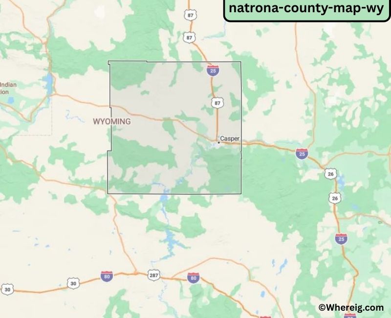
About Natrona County Map, Alabama: The map showing the county boundary, county seat, major cities, highways, water bodies and neighbouring counties.
Most Viewed Links
About Natrona County, Wyoming
Natrona County is located in the central part of Wyoming, United States. Established in 1888, the county was named after the mineral natron, historically mined in the region. The county seat and largest city is Casper, which serves as a major economic and transportation hub in central Wyoming. Natrona County has long been associated with energy production, ranching, and western heritage.
Population
According to the United States Census Bureau, the population of Natrona County was 79,955 as recorded in the 2020 Census. The majority of residents live in Casper, with additional communities spread across the county’s urban and rural areas.
Area and Geography
According to the United States Census Bureau, Natrona County covers a total area of approximately 5,376 square miles, including about 5,340 square miles of land and 36 square miles of water. The county features rolling plains, river valleys along the North Platte River, and portions of the Casper Mountain area.
Bordering Counties
Natrona County shares borders with Johnson County to the north, Converse County to the east, Fremont County to the west, and Carbon County to the south.
Major Cities and Communities
The principal communities in Natrona County include Casper, Mills, Evansville, and Bar Nunn, which serve as residential, commercial, and industrial centers.
Attractions and Recreation
Natrona County offers outdoor recreation opportunities including hiking, fishing, skiing, and camping. Casper Mountain and the North Platte River provide scenic landscapes and year-round activities, while museums and historic sites reflect the region’s energy and frontier heritage.
Transportation
Major transportation routes serving Natrona County include Interstate 25 and U.S. Highways 20, 26, and 287, providing important connections across central Wyoming and neighboring states.
Explore more counties in Wyoming Counties or view the complete USA States Map section for additional geographic information.
Sources:
Population and area data sourced from the United States Census Bureau (2020 Census). General county information referenced from the Official Natrona County Government Website.
Facts about Natrona County, Wyoming
| Country | United States |
| State | Wyoming |
| Region | Central Wyoming |
| County Seat | Casper |
| Named After | Natron (natural soda deposits) |
| Established | 1890 |
| Organized | 1890 |
| Coordinates | 42.96° N, 106.80° W |
| Total Area | 5,376 sq mi |
| Land Area | 5,339 sq mi |
| Water Area | 37 sq mi |
| Population (2020) | 79,858 |
| Population Rank | Third most populous county in Wyoming |
| Largest City | Casper |
| Main Industries | Energy, Healthcare, Government, Transportation |
| Major Highways | Interstate 25, U.S. Highway 20/26, U.S. Highway 287 |
| Time Zone | Mountain Time (UTC−07:00) |
| Known For | Oil and gas production, Platte River, central Wyoming hub |
| Official Website | https://www.natronacountywy.gov |
Top Attractions in Natrona County, Wyoming
- Casper Mountain – Hiking and scenic views.
- Fort Casper Museum – Local history exhibits.
- Natrona County Courthouse – Historic courthouse.
- Downtown Casper Historic District – Shops and dining.
- Nicolaysen Art Museum – Art exhibits and galleries.
- North Platte River – Boating and fishing.
- Community Parks – Picnic and recreation areas.
- Rural Scenic Roadways – Countryside drives.
- Casper Events Center – Concerts and events.
- Historic Rail Depot – Railroad history site.
List of Cities and Towns in Natrona County, Wyoming
Casper, Evansville, Mills, Bar Nunn, Edgerton, Midwest, Hartrandt
- Albany County Map, WY
- Big Horn County Map, WY
- Campbell County Map, WY
- Carbon County Map, WY
- Converse County Map, WY
- Crook County Map, WY
- Fremont County Map, WY
- Goshen County Map, WY
- Hot Springs County Map, WY
- Johnson County Map, WY
- Laramie County Map, WY
- Lincoln County Map, WY
- Natrona County Map, WY
- Niobrara County Map, WY
- Park County Map, WY
- Platte County Map, WY
- Sheridan County Map, WY
- Sublette County Map, WY
- Sweetwater County Map, WY
- Teton County Map, WY
- Uinta County Map, WY
- Washakie County Map, WY
- Weston County Map, WY
- Alabama Counties
- Alaska boroughs
- Arizona Counties
- Arkansas Counties
- California County Map
- Colorado Counties
- Connecticut Counties
- Delaware Counties
- Florida County Map
- Georgia County Map
- Hawaii Counties
- Idaho Counties
- Illinois Counties
- Indiana Counties
- Iowa Counties
- Kansas Counties
- Kentucky Counties
- Louisiana Counties
- Maine Counties
- Maryland Counties
- Massachusetts Counties
- Michigan County Map
- Minnesota Counties
- Mississippi Counties
- Missouri Counties
- Montana Counties
- Nebraska Counties
- Nevada Counties
- New York Counties
- New Hampshire Counties
- New Jersey Counties
- New Mexico Counties
- North Carolina Counties
- North Dakota Counties
- Ohio County Map
- Oklahoma Counties
- Oregon Counties
- Pennsylvania Counties
- Rhode Island Counties
- South Carolina Counties
- South Dakota Counties
- Map of Tennessee
- Texas County Map
- Utah Counties
- Vermont Counties
- Virginia Counties
- Washington Counties
- West Virginia Counties
- Wisconsin Counties
- Wyoming Counties