Map of Converse County - Converse County is a county located in the U.S. state of Wyoming. Converse County Map showing cities, highways, important places and water bodies. Get Where is Converse County located in the map, major cities in Converse county, population, areas, and places of interest.
Map of Converse County, Wyoming
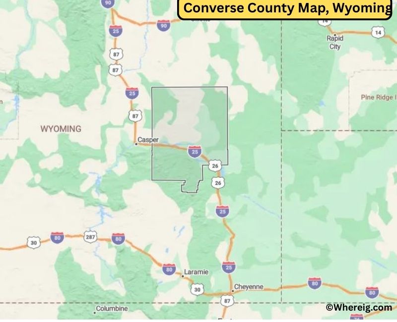
About Converse County Map, Alabama: The map showing the county boundary, county seat, major cities, highways, water bodies and neighbouring counties.
Most Viewed Links
About Converse County, Wyoming
Converse County is located in the east-central part of Wyoming, United States. Established in 1888, the county was named after A.R. Converse, a prominent Wyoming rancher and legislator. The county seat is Douglas, which also serves as the largest city and commercial center of the region. Converse County has a strong heritage rooted in ranching, railroads, and energy development.
Population
According to the United States Census Bureau, the population of Converse County was 13,751 as recorded in the 2020 Census. The majority of residents live in Douglas and Glenrock, while rural areas support agriculture and energy-related industries.
Area and Geography
According to the United States Census Bureau, Converse County covers a total area of approximately 4,265 square miles, including about 4,255 square miles of land and 10 square miles of water. The landscape consists of open plains, rolling hills, and river valleys, with the North Platte River flowing through parts of the county.
Bordering Counties
Converse County shares borders with Campbell County, Weston County, Niobrara County, Platte County, Albany County, and Natrona County.
Major Cities and Communities
The principal communities in Converse County include Douglas and Glenrock, which serve as local centers for education, commerce, and public services, along with smaller rural settlements that support agricultural and ranching operations.
Attractions and Recreation
Converse County offers outdoor recreation opportunities including fishing, hunting, hiking, and camping. The North Platte River and surrounding public lands provide scenic landscapes and reflect Wyoming’s western heritage.
Transportation
Major transportation routes serving Converse County include Interstate 25 and U.S. Route 20, connecting the county to Casper, Cheyenne, and other parts of the state.
Explore more counties in Wyoming Counties or view the complete USA States Map section for additional geographic information.
Sources:
Population and area data sourced from the United States Census Bureau (2020 Census). General county information referenced from the Official Converse County Government Website.
Facts about Converse County, Wyoming
| Country | United States |
| State | Wyoming |
| Region | East-Central Wyoming |
| County Seat | Douglas |
| Named After | Amasa Converse |
| Established | 1888 |
| Organized | 1888 |
| Coordinates | 42.97° N, 105.51° W |
| Total Area | 4,255 sq mi |
| Land Area | 4,242 sq mi |
| Water Area | 13 sq mi |
| Population (2020) | 13,084 |
| Population Rank | Mid-sized county in Wyoming |
| Largest City | Douglas |
| Main Industries | Agriculture, Energy, Manufacturing, Government |
| Major Highways | Interstate 25, U.S. Highway 20, State Highway 59 |
| Time Zone | Mountain Time (UTC−07:00) |
| Known For | Platte River Valley, ranching, proximity to Thunder Basin National Grassland |
| Official Website | https://www.conversecountywy.gov |
Top Attractions in Converse County, Wyoming
- Converse County Courthouse – Historic courthouse.
- Downtown Douglas Historic District – Shops and dining.
- Douglas Railroad Interpretive Center – Rail history exhibits.
- Medicine Bow National Forest (nearby) – Hiking and wildlife.
- Guernsey State Park – Boating and trails.
- Rural Scenic Roadways – Countryside drives.
- Guernsey Dam and Reservoir – Fishing and recreation.
- Historic Fort Fetterman (nearby) – Military history site.
- Community Parks – Picnic and recreation areas.
- Converse County Museum – Local history exhibits.
List of Cities and Towns in Converse County, Wyoming
Douglas, Glenrock, Lost Springs, Rolling Hills, Shawnee
- Albany County Map, WY
- Big Horn County Map, WY
- Campbell County Map, WY
- Carbon County Map, WY
- Converse County Map, WY
- Crook County Map, WY
- Fremont County Map, WY
- Goshen County Map, WY
- Hot Springs County Map, WY
- Johnson County Map, WY
- Laramie County Map, WY
- Lincoln County Map, WY
- Natrona County Map, WY
- Niobrara County Map, WY
- Park County Map, WY
- Platte County Map, WY
- Sheridan County Map, WY
- Sublette County Map, WY
- Sweetwater County Map, WY
- Teton County Map, WY
- Uinta County Map, WY
- Washakie County Map, WY
- Weston County Map, WY
- Alabama Counties
- Alaska boroughs
- Arizona Counties
- Arkansas Counties
- California County Map
- Colorado Counties
- Connecticut Counties
- Delaware Counties
- Florida County Map
- Georgia County Map
- Hawaii Counties
- Idaho Counties
- Illinois Counties
- Indiana Counties
- Iowa Counties
- Kansas Counties
- Kentucky Counties
- Louisiana Counties
- Maine Counties
- Maryland Counties
- Massachusetts Counties
- Michigan County Map
- Minnesota Counties
- Mississippi Counties
- Missouri Counties
- Montana Counties
- Nebraska Counties
- Nevada Counties
- New York Counties
- New Hampshire Counties
- New Jersey Counties
- New Mexico Counties
- North Carolina Counties
- North Dakota Counties
- Ohio County Map
- Oklahoma Counties
- Oregon Counties
- Pennsylvania Counties
- Rhode Island Counties
- South Carolina Counties
- South Dakota Counties
- Map of Tennessee
- Texas County Map
- Utah Counties
- Vermont Counties
- Virginia Counties
- Washington Counties
- West Virginia Counties
- Wisconsin Counties
- Wyoming Counties