Map of Park County - Park County is a county located in the U.S. state of Wyoming. Park County Map showing cities, highways, important places and water bodies. Get Where is Park County located in the map, major cities in Park county, population, areas, and places of interest.
Map of Park County, Wyoming
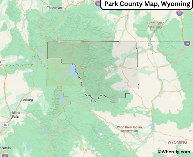
About Park County Map, Alabama: The map showing the county boundary, county seat, major cities, highways, water bodies and neighbouring counties.
Most Viewed Links
About Park County, Wyoming
Park County is located in the northwestern part of Wyoming, United States. Established in 1909, the county was named for its proximity to Yellowstone National Park. The county seat is Cody, which also serves as the largest city and a major gateway to Yellowstone. Park County is known for its scenic mountain landscapes, western heritage, and strong tourism economy.
Population
According to the United States Census Bureau, the population of Park County was 29,624 as recorded in the 2020 Census. The population is primarily concentrated in Cody and Powell, with smaller communities spread across the county.
Area and Geography
According to the United States Census Bureau, Park County covers a total area of approximately 6,967 square miles, including about 6,942 square miles of land and 25 square miles of water. The county features portions of the Absaroka Range, the Shoshone National Forest, and expansive valleys and plains that contribute to its diverse natural setting.
Bordering Counties
Park County shares borders with Montana to the north, Big Horn County to the east, Hot Springs County to the southeast, Fremont County to the south, and Teton County to the west.
Major Cities and Communities
The principal communities in Park County include Cody, Powell, and Meeteetse, which serve as residential, agricultural, and tourism centers.
Attractions and Recreation
Park County offers extensive outdoor recreation opportunities including hiking, fishing, camping, and wildlife viewing. As a gateway to Yellowstone National Park, the county attracts visitors year-round and features scenic highways, museums, and historic sites reflecting Wyoming’s western culture.
Transportation
Major transportation routes serving Park County include U.S. Highways 14, 16, and 20, which provide important connections to Yellowstone National Park and neighboring counties.
Explore more counties in Wyoming Counties or view the complete USA States Map section for additional geographic information.
Sources:
Population and area data sourced from the United States Census Bureau (2020 Census). General county information referenced from the Official Park County Government Website.
Facts about Park County, Wyoming
| Country | United States |
| State | Wyoming |
| Region | Northwestern Wyoming |
| County Seat | Cody |
| Named After | Proximity to Yellowstone National Park |
| Established | 1909 |
| Organized | 1909 |
| Coordinates | 44.52° N, 109.59° W |
| Total Area | 6,967 sq mi |
| Land Area | 6,941 sq mi |
| Water Area | 26 sq mi |
| Population (2020) | 29,624 |
| Population Rank | Mid-sized county in Wyoming |
| Largest City | Cody |
| Main Industries | Tourism, Agriculture, Healthcare, Government |
| Major Highways | U.S. Highway 14/16/20, State Highway 120 |
| Time Zone | Mountain Time (UTC−07:00) |
| Known For | Gateway to Yellowstone National Park, Buffalo Bill Center of the West, scenic landscapes |
| Official Website | https://www.parkcounty.us |
Top Attractions in Park County, Wyoming
- Yellowstone National Park (north entrance) – Wildlife and geysers.
- Old Faithful Visitor Center – Geyser viewing and exhibits.
- Park County Courthouse – Historic courthouse.
- Downtown Cody Historic District – Shops and dining.
- Buffalo Bill Center of the West – Museums and exhibits.
- Shoshone River – Fishing and scenic views.
- Rural Scenic Roadways – Countryside drives.
- Community Parks – Picnic and recreation areas.
- Historic Cody Stampede Grounds – Rodeo and events.
- Heart Mountain Interpretive Center – Historical exhibits.
List of Cities and Towns in Park County, Wyoming
Cody, Powell, Meeteetse, Frannie
- Albany County Map, WY
- Big Horn County Map, WY
- Campbell County Map, WY
- Carbon County Map, WY
- Converse County Map, WY
- Crook County Map, WY
- Fremont County Map, WY
- Goshen County Map, WY
- Hot Springs County Map, WY
- Johnson County Map, WY
- Laramie County Map, WY
- Lincoln County Map, WY
- Natrona County Map, WY
- Niobrara County Map, WY
- Park County Map, WY
- Platte County Map, WY
- Sheridan County Map, WY
- Sublette County Map, WY
- Sweetwater County Map, WY
- Teton County Map, WY
- Uinta County Map, WY
- Washakie County Map, WY
- Weston County Map, WY
- Alabama Counties
- Alaska boroughs
- Arizona Counties
- Arkansas Counties
- California County Map
- Colorado Counties
- Connecticut Counties
- Delaware Counties
- Florida County Map
- Georgia County Map
- Hawaii Counties
- Idaho Counties
- Illinois Counties
- Indiana Counties
- Iowa Counties
- Kansas Counties
- Kentucky Counties
- Louisiana Counties
- Maine Counties
- Maryland Counties
- Massachusetts Counties
- Michigan County Map
- Minnesota Counties
- Mississippi Counties
- Missouri Counties
- Montana Counties
- Nebraska Counties
- Nevada Counties
- New York Counties
- New Hampshire Counties
- New Jersey Counties
- New Mexico Counties
- North Carolina Counties
- North Dakota Counties
- Ohio County Map
- Oklahoma Counties
- Oregon Counties
- Pennsylvania Counties
- Rhode Island Counties
- South Carolina Counties
- South Dakota Counties
- Map of Tennessee
- Texas County Map
- Utah Counties
- Vermont Counties
- Virginia Counties
- Washington Counties
- West Virginia Counties
- Wisconsin Counties
- Wyoming Counties