Map of Sheridan County - Sheridan County is a county located in the U.S. state of Wyoming. Sheridan County Map showing cities, highways, important places and water bodies. Get Where is Sheridan County located in the map, major cities in Sheridan county, population, areas, and places of interest.
Map of Sheridan County, Wyoming
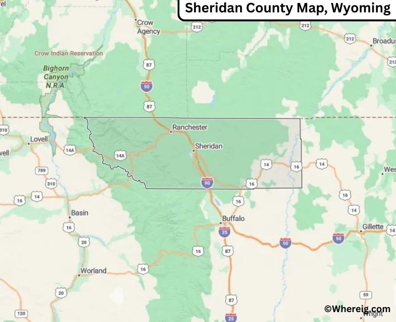
About Sheridan County Map, Alabama: The map showing the county boundary, county seat, major cities, highways, water bodies and neighbouring counties.
Most Viewed Links
About Sheridan County, Wyoming
Sheridan County is located in the north-central part of Wyoming, United States. Established in 1888, the county was named after General Philip H. Sheridan. The county seat and largest city is Sheridan, which serves as a regional center for commerce, healthcare, and tourism. The county is known for its western heritage and scenic landscapes near the Bighorn Mountains.
Population
According to the United States Census Bureau, the population of Sheridan County was 30,921 as recorded in the 2020 Census. The majority of residents live in Sheridan, with additional communities distributed throughout the county.
Area and Geography
According to the United States Census Bureau, Sheridan County covers a total area of approximately 2,527 square miles, including about 2,524 square miles of land and 3 square miles of water. The county features foothills, river valleys, and portions of the Bighorn Mountains, offering diverse natural scenery and outdoor recreation opportunities.
Bordering Counties
Sheridan County shares borders with the state of Montana to the north, Big Horn County to the west, Johnson County to the south, and Campbell County to the southeast.
Major Cities and Communities
The principal communities in Sheridan County include Sheridan, Ranchester, Dayton, and Clearmont, which serve as residential, agricultural, and commercial centers.
Attractions and Recreation
Sheridan County offers outdoor recreation including hiking, fishing, camping, and skiing in the nearby Bighorn Mountains. Historic downtown Sheridan and regional museums highlight the county’s ranching history and western traditions.
Transportation
Major transportation routes serving Sheridan County include Interstate 90 and U.S. Highways 14 and 87, providing connectivity to Montana and other parts of northern Wyoming.
Explore more counties in Wyoming Counties or view the complete USA States Map section for additional geographic information.
Sources:
Population and area data sourced from the United States Census Bureau (2020 Census). General county information referenced from the Official Sheridan Coun
Sheridan, Ranchester, Dayton, ClearmontFacts about Sheridan County, Wyoming
Country United States State Wyoming Region Northern Wyoming County Seat Sheridan Named After General Philip Sheridan Established 1888 Organized 1888 Coordinates 44.79° N, 106.88° W Total Area 2,524 sq mi Land Area 2,523 sq mi Water Area 1 sq mi Population (2020) 30,881 Population Rank Mid-sized county in Wyoming Largest City Sheridan Main Industries Healthcare, Education, Agriculture, Tourism Major Highways Interstate 90, U.S. Highway 14, U.S. Highway 87 Time Zone Mountain Time (UTC−07:00) Known For Bighorn Mountains, western heritage, arts and culture Official Website https://www.sheridancountywy.gov Top Attractions in Sheridan County, Wyoming
List of Cities and Towns in Sheridan County, Wyoming