Map of Campbell County - Campbell County is a county located in the U.S. state of Wyoming. Campbell County Map showing cities, highways, important places and water bodies. Get Where is Campbell County located in the map, major cities in Campbell county, population, areas, and places of interest.
Map of Campbell County, Wyoming
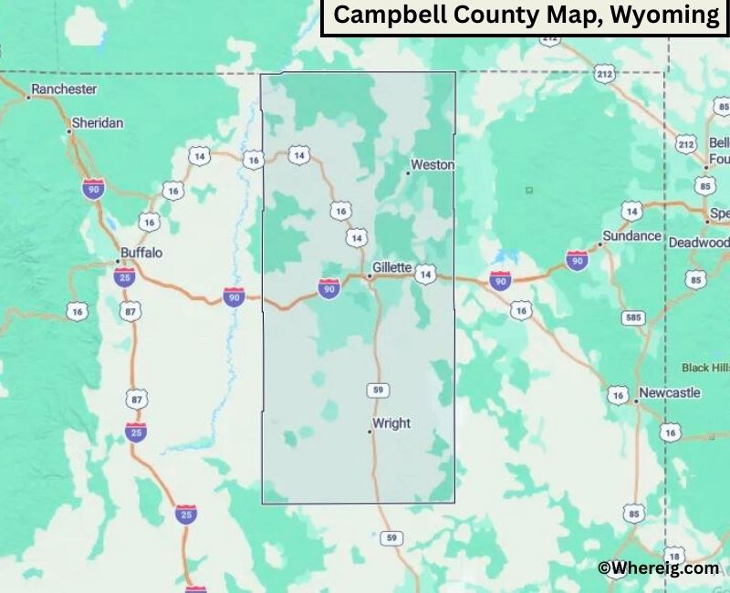
About Campbell County Map, Alabama: The map showing the county boundary, county seat, major cities, highways, water bodies and neighbouring counties.
Most Viewed Links
About Campbell County, Wyoming
Campbell County is located in the northeastern part of Wyoming, United States. Established in 1911, the county was named after John Allen Campbell, the first governor of the Wyoming Territory. The county seat and largest city is Gillette, which serves as a major center for energy production and regional commerce.
Population
According to the United States Census Bureau, the population of Campbell County was 47,026 as recorded in the 2020 Census. The county’s population is concentrated in Gillette, with smaller rural communities spread across the region.
Area and Geography
According to the United States Census Bureau, Campbell County covers a total area of approximately 4,807 square miles, including about 4,797 square miles of land and 10 square miles of water. The county features rolling plains, grasslands, and energy-producing regions typical of northeastern Wyoming.
Bordering Counties
Campbell County shares borders with Sheridan County to the north, Johnson County to the west, Converse County to the southwest, and Weston County to the south, while its eastern boundary meets the state of South Dakota.
Major Cities and Communities
The principal community in Campbell County is Gillette, which serves as the county seat and economic hub. Other smaller communities include Wright and Recluse.
Attractions and Recreation
Campbell County offers outdoor recreation opportunities including hiking, hunting, and exploring open prairie landscapes. The county is known for its role in coal mining and energy production, which has shaped its economic development and regional identity.
Transportation
Major transportation routes serving Campbell County include Interstate 90 and U.S. Route 14-16, connecting the county to other parts of northeastern Wyoming and neighboring states.
Explore more counties in Wyoming Counties or view the complete USA States Map section for additional geographic information.
Sources:
Population and area data sourced from the United States Census Bureau (2020 Census). General county information referenced from the Official Campbell County Government Website.
Facts about Campbell County, Wyoming
| Country | United States |
| State | Wyoming |
| Region | Northeastern Wyoming |
| County Seat | Gillette |
| Named After | John A. Campbell |
| Established | 1911 |
| Organized | 1911 |
| Coordinates | 44.25° N, 105.55° W |
| Total Area | 4,807 sq mi |
| Land Area | 4,798 sq mi |
| Water Area | 9 sq mi |
| Population (2020) | 46,042 |
| Population Rank | Most populous county in Wyoming |
| Largest City | Gillette |
| Main Industries | Coal Mining, Energy Production, Agriculture, Manufacturing |
| Major Highways | Interstate 90, U.S. Highway 14/16, State Highway 59 |
| Time Zone | Mountain Time (UTC−07:00) |
| Known For | Powder River Basin coal mines, energy production, high plains |
| Official Website | https://www.ccgwyoming.com |
Top Attractions in Campbell County, Wyoming
- Campbell County Courthouse – Historic courthouse.
- Gillette Historic District – Downtown shops and dining.
- Donkey Creek Trail – Hiking and nature trails.
- Rockpile Museum – Local history exhibits.
- Little Powder River Recreation Area – Outdoor activities.
- Lake DeSmet – Fishing and boating.
- Rural Scenic Roadways – Countryside drives.
- Campbell County Rockpile – Scenic viewpoints.
- Historic Gillette Depot – Rail history site.
- Campbell County Fairgrounds – Annual fairs and events.
List of Cities and Towns in Campbell County, Wyoming
Gillette, Wright, Recluse, Rozet
- Albany County Map, WY
- Big Horn County Map, WY
- Campbell County Map, WY
- Carbon County Map, WY
- Converse County Map, WY
- Crook County Map, WY
- Fremont County Map, WY
- Goshen County Map, WY
- Hot Springs County Map, WY
- Johnson County Map, WY
- Laramie County Map, WY
- Lincoln County Map, WY
- Natrona County Map, WY
- Niobrara County Map, WY
- Park County Map, WY
- Platte County Map, WY
- Sheridan County Map, WY
- Sublette County Map, WY
- Sweetwater County Map, WY
- Teton County Map, WY
- Uinta County Map, WY
- Washakie County Map, WY
- Weston County Map, WY
- Alabama Counties
- Alaska boroughs
- Arizona Counties
- Arkansas Counties
- California County Map
- Colorado Counties
- Connecticut Counties
- Delaware Counties
- Florida County Map
- Georgia County Map
- Hawaii Counties
- Idaho Counties
- Illinois Counties
- Indiana Counties
- Iowa Counties
- Kansas Counties
- Kentucky Counties
- Louisiana Counties
- Maine Counties
- Maryland Counties
- Massachusetts Counties
- Michigan County Map
- Minnesota Counties
- Mississippi Counties
- Missouri Counties
- Montana Counties
- Nebraska Counties
- Nevada Counties
- New York Counties
- New Hampshire Counties
- New Jersey Counties
- New Mexico Counties
- North Carolina Counties
- North Dakota Counties
- Ohio County Map
- Oklahoma Counties
- Oregon Counties
- Pennsylvania Counties
- Rhode Island Counties
- South Carolina Counties
- South Dakota Counties
- Map of Tennessee
- Texas County Map
- Utah Counties
- Vermont Counties
- Virginia Counties
- Washington Counties
- West Virginia Counties
- Wisconsin Counties
- Wyoming Counties