Map of Teton County - Teton County is a county located in the U.S. state of Wyoming. Teton County Map showing cities, highways, important places and water bodies. Get Where is Teton County located in the map, major cities in Teton county, population, areas, and places of interest.
Map of Teton County, Wyoming
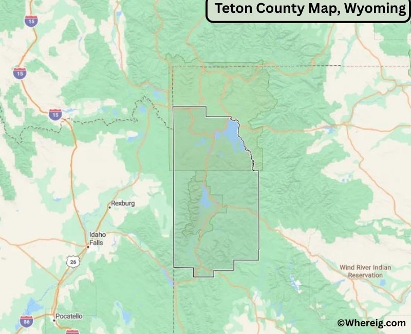
About Teton County Map, Alabama: The map showing the county boundary, county seat, major cities, highways, water bodies and neighbouring counties.
Most Viewed Links
About Teton County, Wyoming
Teton County is located in the northwestern corner of Wyoming, United States. Established in 1921, the county was named after the Teton Range. The county seat and largest town is Jackson, which serves as the primary gateway to Grand Teton and Yellowstone National Parks. Teton County is widely recognized for its stunning mountain landscapes, outdoor recreation, and tourism-driven economy.
Population
According to the United States Census Bureau, the population of Teton County was 23,331 as recorded in the 2020 Census. The population is largely concentrated in Jackson and nearby communities, with seasonal fluctuations due to tourism.
Area and Geography
According to the United States Census Bureau, Teton County covers a total area of approximately 4,216 square miles, including about 3,995 square miles of land and 221 square miles of water. The county features the Teton Range, portions of Yellowstone National Park, Grand Teton National Park, and extensive protected wilderness areas.
Bordering Counties
Teton County shares borders with the state of Montana to the north, Park County to the east, Fremont County to the southeast, Sublette County to the south, and the state of Idaho to the west.
Major Cities and Communities
The principal communities in Teton County include Jackson, Teton Village, and Wilson, which serve as residential, recreational, and tourism centers.
Attractions and Recreation
Teton County offers world-class outdoor recreation including hiking, skiing, wildlife viewing, mountaineering, and river rafting. Grand Teton National Park and nearby ski resorts attract visitors year-round, making tourism a cornerstone of the local economy.
Transportation
Major transportation routes serving Teton County include U.S. Highways 26, 89, and 191, which provide access to neighboring counties and nearby national parks.
Explore more counties in Wyoming Counties or view the complete USA States Map section for additional geographic information.
Sources:
Population and area data sourced from the United States Census Bureau (2020 Census). General county information referenced from the Official Teton County Government Website.
Facts about Teton County, Wyoming
| Country | United States |
| State | Wyoming |
| Region | Northwestern Wyoming |
| County Seat | Jackson |
| Named After | Teton Mountain Range |
| Established | 1921 |
| Organized | 1921 |
| Coordinates | 43.93° N, 110.68° W |
| Total Area | 4,214 sq mi |
| Land Area | 3,996 sq mi |
| Water Area | 218 sq mi |
| Population (2020) | 23,464 |
| Population Rank | Mid-sized county in Wyoming |
| Largest Town | Jackson |
| Main Industries | Tourism, Outdoor Recreation, Real Estate, Services |
| Major Highways | U.S. Highway 26, U.S. Highway 89, U.S. Highway 191 |
| Time Zone | Mountain Time (UTC−07:00) |
| Known For | Grand Teton National Park, Jackson Hole, ski resorts |
| Official Website | https://www.tetoncountywy.gov |
Top Attractions in Teton County, Wyoming
- Grand Teton National Park – Hiking and scenic mountains.
- Jackson Hole – Shops, dining, and outdoor recreation.
- National Museum of Wildlife Art – Art exhibits.
- Jenny Lake – Boating and hiking trails.
- Teton County Courthouse – Historic courthouse.
- Snake River – Fishing and kayaking.
- Rural Scenic Roadways – Countryside drives.
- Community Parks – Picnic and recreation areas.
- Historic Jackson Town Square – Shops and events.
- Jackson Hole Rodeo – Seasonal rodeo events.
List of Cities and Towns in Teton County, Wyoming
Jackson, Wilson, Moose, Kelly, Moran
- Albany County Map, WY
- Big Horn County Map, WY
- Campbell County Map, WY
- Carbon County Map, WY
- Converse County Map, WY
- Crook County Map, WY
- Fremont County Map, WY
- Goshen County Map, WY
- Hot Springs County Map, WY
- Johnson County Map, WY
- Laramie County Map, WY
- Lincoln County Map, WY
- Natrona County Map, WY
- Niobrara County Map, WY
- Park County Map, WY
- Platte County Map, WY
- Sheridan County Map, WY
- Sublette County Map, WY
- Sweetwater County Map, WY
- Teton County Map, WY
- Uinta County Map, WY
- Washakie County Map, WY
- Weston County Map, WY
- Alabama Counties
- Alaska boroughs
- Arizona Counties
- Arkansas Counties
- California County Map
- Colorado Counties
- Connecticut Counties
- Delaware Counties
- Florida County Map
- Georgia County Map
- Hawaii Counties
- Idaho Counties
- Illinois Counties
- Indiana Counties
- Iowa Counties
- Kansas Counties
- Kentucky Counties
- Louisiana Counties
- Maine Counties
- Maryland Counties
- Massachusetts Counties
- Michigan County Map
- Minnesota Counties
- Mississippi Counties
- Missouri Counties
- Montana Counties
- Nebraska Counties
- Nevada Counties
- New York Counties
- New Hampshire Counties
- New Jersey Counties
- New Mexico Counties
- North Carolina Counties
- North Dakota Counties
- Ohio County Map
- Oklahoma Counties
- Oregon Counties
- Pennsylvania Counties
- Rhode Island Counties
- South Carolina Counties
- South Dakota Counties
- Map of Tennessee
- Texas County Map
- Utah Counties
- Vermont Counties
- Virginia Counties
- Washington Counties
- West Virginia Counties
- Wisconsin Counties
- Wyoming Counties