Map of Carbon County - Carbon County is a county located in the U.S. state of Wyoming. Carbon County Map showing cities, highways, important places and water bodies. Get Where is Carbon County located in the map, major cities in Carbon county, population, areas, and places of interest.
Map of Carbon County, Wyoming
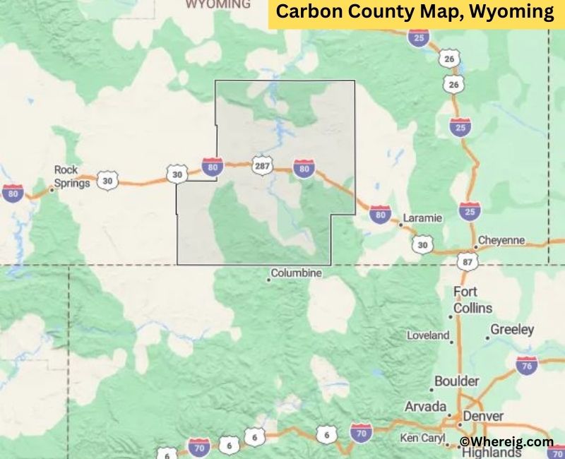
About Carbon County Map, Alabama: The map showing the county boundary, county seat, major cities, highways, water bodies and neighbouring counties.
Most Viewed Links
About Carbon County, Wyoming
Carbon County is located in the south-central part of Wyoming, United States, along the border with Colorado. Established in 1868, the county was named for the coal deposits discovered in the region. The county seat is Rawlins, which serves as the primary administrative and commercial center of the county.
Population
According to the United States Census Bureau, the population of Carbon County was 14,537 as recorded in the 2020 Census. The county includes small towns and rural communities, with residents concentrated in Rawlins and surrounding areas.
Area and Geography
According to the United States Census Bureau, Carbon County covers a total area of approximately 7,964 square miles, including about 7,896 square miles of land and 68 square miles of water. It is one of the largest counties in Wyoming by area and features mountains, high plains, and river valleys.
Bordering Counties
Carbon County shares borders with Sweetwater County to the west, Natrona County to the north, Albany County to the east, and the state of Colorado to the south.
Major Cities and Communities
The principal communities in Carbon County include Rawlins, Saratoga, and Hanna. Rawlins serves as the county seat and a key transportation and service hub.
Attractions and Recreation
Carbon County offers outdoor recreation opportunities including hiking, fishing, and camping in the Medicine Bow Mountains and along the North Platte River. Historic sites related to the railroad and mining industries reflect the county’s heritage.
Transportation
Major transportation routes serving Carbon County include Interstate 80 and U.S. Route 287, providing connections across southern Wyoming and into neighboring Colorado.
Explore more counties in Wyoming Counties or view the complete USA States Map section for additional geographic information.
Sources:
Population and area data sourced from the United States Census Bureau (2020 Census). General county information referenced from the Official Carbon County Government Website.
Facts about Carbon County, Wyoming
| Country | United States |
| State | Wyoming |
| Region | South-Central Wyoming |
| County Seat | Rawlins |
| Named After | Coal (carbon) deposits |
| Established | 1868 |
| Organized | 1868 |
| Coordinates | 41.70° N, 106.93° W |
| Total Area | 7,964 sq mi |
| Land Area | 7,897 sq mi |
| Water Area | 67 sq mi |
| Population (2020) | 14,800 |
| Population Rank | Mid-sized county in Wyoming |
| Largest City | Rawlins |
| Main Industries | Energy, Transportation, Government, Agriculture |
| Major Highways | Interstate 80, U.S. Highway 287, State Highway 789 |
| Time Zone | Mountain Time (UTC−07:00) |
| Known For | Union Pacific Railroad history, energy resources, high desert landscapes |
| Official Website | https://www.carboncountywy.gov |
Top Attractions in Carbon County, Wyoming
- Medicine Bow National Forest – Hiking and wildlife.
- Carbon County Courthouse – Historic courthouse.
- Historic Downtown Rawlins – Shops and dining.
- Wyoming Frontier Prison Museum – Historic prison tours.
- Seminoe State Park – Boating and camping.
- Rural Scenic Roadways – Countryside drives.
- Savage Run Wilderness – Hiking and nature trails.
- Carbon County Museum – Local history exhibits.
- Seminoe Reservoir – Fishing and water recreation.
- Seminoe Mountains – Scenic overlooks and trails.
List of Cities and Towns in Carbon County, Wyoming
Rawlins, Saratoga, Hanna, Elk Mountain, Medicine Bow, Sinclair
- Albany County Map, WY
- Big Horn County Map, WY
- Campbell County Map, WY
- Carbon County Map, WY
- Converse County Map, WY
- Crook County Map, WY
- Fremont County Map, WY
- Goshen County Map, WY
- Hot Springs County Map, WY
- Johnson County Map, WY
- Laramie County Map, WY
- Lincoln County Map, WY
- Natrona County Map, WY
- Niobrara County Map, WY
- Park County Map, WY
- Platte County Map, WY
- Sheridan County Map, WY
- Sublette County Map, WY
- Sweetwater County Map, WY
- Teton County Map, WY
- Uinta County Map, WY
- Washakie County Map, WY
- Weston County Map, WY
- Alabama Counties
- Alaska boroughs
- Arizona Counties
- Arkansas Counties
- California County Map
- Colorado Counties
- Connecticut Counties
- Delaware Counties
- Florida County Map
- Georgia County Map
- Hawaii Counties
- Idaho Counties
- Illinois Counties
- Indiana Counties
- Iowa Counties
- Kansas Counties
- Kentucky Counties
- Louisiana Counties
- Maine Counties
- Maryland Counties
- Massachusetts Counties
- Michigan County Map
- Minnesota Counties
- Mississippi Counties
- Missouri Counties
- Montana Counties
- Nebraska Counties
- Nevada Counties
- New York Counties
- New Hampshire Counties
- New Jersey Counties
- New Mexico Counties
- North Carolina Counties
- North Dakota Counties
- Ohio County Map
- Oklahoma Counties
- Oregon Counties
- Pennsylvania Counties
- Rhode Island Counties
- South Carolina Counties
- South Dakota Counties
- Map of Tennessee
- Texas County Map
- Utah Counties
- Vermont Counties
- Virginia Counties
- Washington Counties
- West Virginia Counties
- Wisconsin Counties
- Wyoming Counties