Map of Lincoln County - Lincoln County is a county located in the U.S. state of Wyoming. Lincoln County Map showing cities, highways, important places and water bodies. Get Where is Lincoln County located in the map, major cities in Lincoln county, population, areas, and places of interest.
Map of Lincoln County, Wyoming
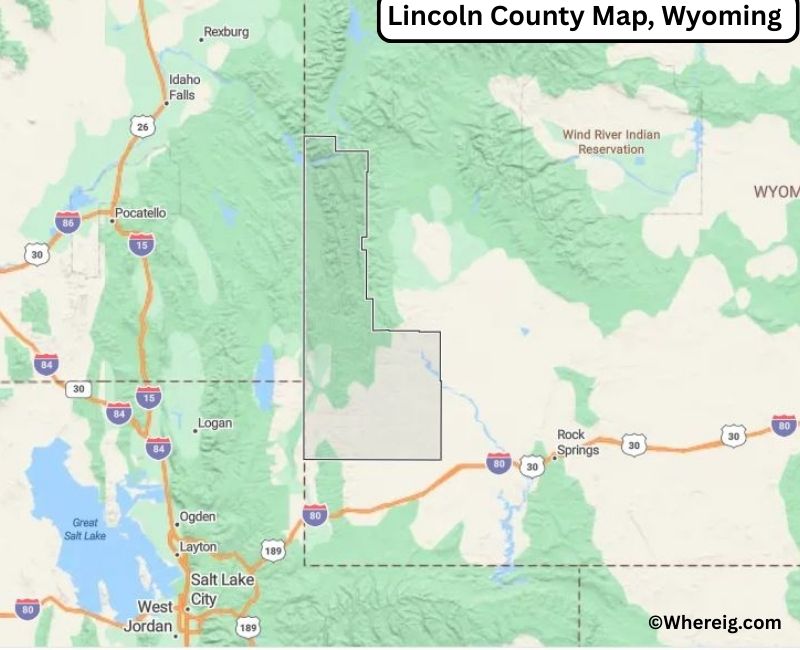
About Lincoln County Map, Alabama: The map showing the county boundary, county seat, major cities, highways, water bodies and neighbouring counties.
Most Viewed Links
About Lincoln County, Wyoming
Lincoln County is located in the western part of Wyoming, United States. Established in 1911, the county was named in honor of President Abraham Lincoln. The county seat is Kemmerer, while the largest city is Evanston, which serves as a regional center for commerce and transportation near the Utah border. Lincoln County is known for its scenic mountain landscapes, energy resources, and outdoor recreation.
Population
According to the United States Census Bureau, the population of Lincoln County was 19,581 as recorded in the 2020 Census. The population is concentrated in Evanston and Kemmerer, with smaller communities spread across the county’s rural areas.
Area and Geography
According to the United States Census Bureau, Lincoln County covers a total area of approximately 4,095 square miles, including about 4,076 square miles of land and 19 square miles of water. The county features portions of the Uinta Mountains, high desert plains, and forested regions that contribute to its diverse natural environment.
Bordering Counties
Lincoln County shares borders with Sublette County to the north, Sweetwater County to the east, the state of Utah to the south, and the state of Idaho to the west.
Major Cities and Communities
The principal communities in Lincoln County include Evanston, Kemmerer, Afton and Star Valley Ranch, which serve as residential, commercial, and recreational centers.
Attractions and Recreation
Lincoln County offers outdoor recreation opportunities including hiking, fishing, skiing, and camping. The county’s mountains, forests, and rivers attract visitors seeking year-round activities and scenic western landscapes.
Transportation
Major transportation routes serving Lincoln County include Interstate 80 in the southern portion of the county and U.S. Highways 30 and 89, providing connections to neighboring states and communities across western Wyoming.
Explore more counties in Wyoming Counties or view the complete USA States Map section for additional geographic information.
Sources:
Population and area data sourced from the United States Census Bureau (2020 Census). General county information referenced from the Official Lincoln County Government Website.
Facts about Lincoln County, Wyoming
| Country | United States |
| State | Wyoming |
| Region | Southwestern Wyoming |
| County Seat | Kemmerer |
| Named After | Abraham Lincoln |
| Established | 1911 |
| Organized | 1911 |
| Coordinates | 42.26° N, 110.65° W |
| Total Area | 4,079 sq mi |
| Land Area | 4,066 sq mi |
| Water Area | 13 sq mi |
| Population (2020) | 18,756 |
| Population Rank | Mid-sized county in Wyoming |
| Largest Town | Kemmerer |
| Main Industries | Energy, Agriculture, Government, Tourism |
| Major Highways | U.S. Highway 30, U.S. Highway 189, State Highway 372 |
| Time Zone | Mountain Time (UTC−07:00) |
| Known For | Fossil Butte National Monument, coal mining, ranching |
| Official Website | https://www.lincolncountywy.gov |
Top Attractions in Lincoln County, Wyoming
- Bridger-Teton National Forest – Hiking and wildlife.
- Lincoln County Courthouse – Historic courthouse.
- Historic Downtown Kemmerer – Shops and dining.
- Fossil Butte National Monument – Fossil exhibits and trails.
- Granger Lake – Boating and fishing.
- Rural Scenic Roadways – Countryside drives.
- Community Parks – Picnic and recreation areas.
- Lincoln County Museum – Local history exhibits.
- Bear River Scenic Area – Nature trails and wildlife.
- Historic Coal Mining Sites – Early industrial landmarks.
List of Cities and Towns in Lincoln County, Wyoming
Kemmerer, Afton, Alpine, Cokeville, Diamondville, La Barge, Thayne, Etna, Freedom
- Albany County Map, WY
- Big Horn County Map, WY
- Campbell County Map, WY
- Carbon County Map, WY
- Converse County Map, WY
- Crook County Map, WY
- Fremont County Map, WY
- Goshen County Map, WY
- Hot Springs County Map, WY
- Johnson County Map, WY
- Laramie County Map, WY
- Lincoln County Map, WY
- Natrona County Map, WY
- Niobrara County Map, WY
- Park County Map, WY
- Platte County Map, WY
- Sheridan County Map, WY
- Sublette County Map, WY
- Sweetwater County Map, WY
- Teton County Map, WY
- Uinta County Map, WY
- Washakie County Map, WY
- Weston County Map, WY
- Alabama Counties
- Alaska boroughs
- Arizona Counties
- Arkansas Counties
- California County Map
- Colorado Counties
- Connecticut Counties
- Delaware Counties
- Florida County Map
- Georgia County Map
- Hawaii Counties
- Idaho Counties
- Illinois Counties
- Indiana Counties
- Iowa Counties
- Kansas Counties
- Kentucky Counties
- Louisiana Counties
- Maine Counties
- Maryland Counties
- Massachusetts Counties
- Michigan County Map
- Minnesota Counties
- Mississippi Counties
- Missouri Counties
- Montana Counties
- Nebraska Counties
- Nevada Counties
- New York Counties
- New Hampshire Counties
- New Jersey Counties
- New Mexico Counties
- North Carolina Counties
- North Dakota Counties
- Ohio County Map
- Oklahoma Counties
- Oregon Counties
- Pennsylvania Counties
- Rhode Island Counties
- South Carolina Counties
- South Dakota Counties
- Map of Tennessee
- Texas County Map
- Utah Counties
- Vermont Counties
- Virginia Counties
- Washington Counties
- West Virginia Counties
- Wisconsin Counties
- Wyoming Counties