Map of Laramie County - Laramie County is a county located in the U.S. state of Wyoming. Laramie County Map showing cities, highways, important places and water bodies. Get Where is Laramie County located in the map, major cities in Laramie county, population, areas, and places of interest.
Map of Laramie County, Wyoming
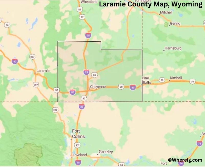
About Laramie County Map, Alabama: The map showing the county boundary, county seat, major cities, highways, water bodies and neighbouring counties.
Most Viewed Links
About Laramie County, Wyoming
Laramie County is located in the southeastern corner of Wyoming, United States. Established in 1867, it is the oldest county in the state and was named after the Laramie River. The county seat and largest city is Cheyenne, which also serves as the state capital. Laramie County plays a central role in state government, commerce, and transportation.
Population
According to the United States Census Bureau, the population of Laramie County was 100,512 as recorded in the 2020 Census. It is the most populous county in Wyoming, with the majority of residents living in Cheyenne and surrounding communities.
Area and Geography
According to the United States Census Bureau, Laramie County covers a total area of approximately 2,688 square miles, including about 2,686 square miles of land and 2 square miles of water. The county features high plains, rolling grasslands, and portions of the Front Range near the Colorado border.
Bordering Counties
Laramie County shares borders with Platte County to the north, Goshen County to the northeast, Nebraska to the east, Colorado to the south, and Albany County to the west.
Major Cities and Communities
The principal communities in Laramie County include Cheyenne, Wheatland, and Burns, which serve as key residential and commercial centers within the county.
Attractions and Recreation
Laramie County offers historic landmarks, museums, and annual events such as Cheyenne Frontier Days. Outdoor recreation opportunities include hiking, camping, and exploring open prairie landscapes and nearby mountain areas.
Transportation
Major transportation routes serving Laramie County include Interstate 25 and Interstate 80, along with U.S. Highways 30 and 85, providing important regional and interstate connections.
Explore more counties in Wyoming Counties or view the complete USA States Map section for additional geographic information.
Sources:
Population and area data sourced from the United States Census Bureau (2020 Census). General county information referenced from the Official Laramie County Government Website.
Facts about Laramie County, Wyoming
| Country | United States |
| State | Wyoming |
| Region | Southeastern Wyoming |
| County Seat | Cheyenne |
| Named After | Laramie River (named for French-Canadian trapper Jacques LaRamée) |
| Established | 1867 |
| Organized | 1867 |
| Coordinates | 41.31° N, 104.66° W |
| Total Area | 2,688 sq mi |
| Land Area | 2,685 sq mi |
| Water Area | 3 sq mi |
| Population (2020) | 100,512 |
| Population Rank | Second most populous county in Wyoming |
| Largest City | Cheyenne |
| Main Industries | Government, Military, Transportation, Healthcare |
| Major Highways | Interstate 25, Interstate 80, U.S. Highway 85 |
| Time Zone | Mountain Time (UTC−07:00) |
| Known For | Wyoming state capital, F.E. Warren Air Force Base, frontier history |
| Official Website | https://www.laramiecountywy.gov |
Top Attractions in Laramie County, Wyoming
- Wyoming State Capitol – Historic government building.
- Cheyenne Depot Museum – Railroad history exhibits.
- Wyoming State Museum – Artifacts and natural history.
- Frontier Park – Rodeo events and recreation.
- Laramie County Courthouse – Historic courthouse.
- Historic Downtown Cheyenne – Shops and dining.
- Union Pacific Railroad Park – Train displays and trails.
- Wyoming Territorial Prison State Historic Site – Historic prison tours.
- Community Parks – Picnic and recreation areas.
- Rural Scenic Roadways – Countryside drives.
List of Cities and Towns in Laramie County, Wyoming
Cheyenne, Burns, Pine Bluffs, Albin, Carpenter
- Albany County Map, WY
- Big Horn County Map, WY
- Campbell County Map, WY
- Carbon County Map, WY
- Converse County Map, WY
- Crook County Map, WY
- Fremont County Map, WY
- Goshen County Map, WY
- Hot Springs County Map, WY
- Johnson County Map, WY
- Laramie County Map, WY
- Lincoln County Map, WY
- Natrona County Map, WY
- Niobrara County Map, WY
- Park County Map, WY
- Platte County Map, WY
- Sheridan County Map, WY
- Sublette County Map, WY
- Sweetwater County Map, WY
- Teton County Map, WY
- Uinta County Map, WY
- Washakie County Map, WY
- Weston County Map, WY
- Alabama Counties
- Alaska boroughs
- Arizona Counties
- Arkansas Counties
- California County Map
- Colorado Counties
- Connecticut Counties
- Delaware Counties
- Florida County Map
- Georgia County Map
- Hawaii Counties
- Idaho Counties
- Illinois Counties
- Indiana Counties
- Iowa Counties
- Kansas Counties
- Kentucky Counties
- Louisiana Counties
- Maine Counties
- Maryland Counties
- Massachusetts Counties
- Michigan County Map
- Minnesota Counties
- Mississippi Counties
- Missouri Counties
- Montana Counties
- Nebraska Counties
- Nevada Counties
- New York Counties
- New Hampshire Counties
- New Jersey Counties
- New Mexico Counties
- North Carolina Counties
- North Dakota Counties
- Ohio County Map
- Oklahoma Counties
- Oregon Counties
- Pennsylvania Counties
- Rhode Island Counties
- South Carolina Counties
- South Dakota Counties
- Map of Tennessee
- Texas County Map
- Utah Counties
- Vermont Counties
- Virginia Counties
- Washington Counties
- West Virginia Counties
- Wisconsin Counties
- Wyoming Counties