Map of Johnson County - Johnson County is a county located in the U.S. state of Wyoming. Johnson County Map showing cities, highways, important places and water bodies. Get Where is Johnson County located in the map, major cities in Johnson county, population, areas, and places of interest.
Map of Johnson County, Wyoming
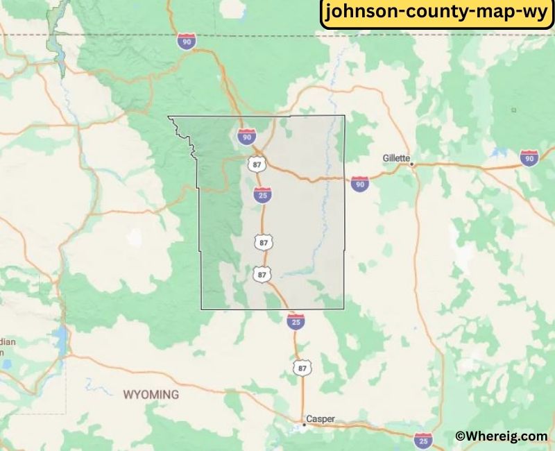
About Johnson County Map, Alabama: The map showing the county boundary, county seat, major cities, highways, water bodies and neighbouring counties.
Most Viewed Links
About Johnson County, Wyoming
Johnson County is located in the north-central part of Wyoming, United States. Established in 1875, the county was named after Edwin P. Johnson, a U.S. Senator from Wyoming. The county seat and largest town is Buffalo, which serves as the economic and cultural center of the region. Johnson County is known for its western heritage, ranching traditions, and scenic landscapes near the Bighorn Mountains.
Population
According to the United States Census Bureau, the population of Johnson County was 8,447 as recorded in the 2020 Census. The population is primarily concentrated in Buffalo, with smaller communities supporting ranching and local businesses.
Area and Geography
According to the United States Census Bureau, Johnson County covers a total area of approximately 4,175 square miles, including about 4,154 square miles of land and 21 square miles of water. The county features rolling plains, foothills, and portions of the Bighorn Mountains, offering diverse natural scenery and outdoor recreation opportunities.
Bordering Counties
Johnson County shares borders with Sheridan County to the north, Campbell County to the east, Converse County to the south, Natrona County to the southwest, and Washakie County to the west.
Major Cities and Communities
The principal communities in Johnson County include Buffalo and Kaycee, which serve as local hubs for commerce, tourism, and community life.
Attractions and Recreation
Johnson County offers outdoor recreation opportunities including hiking, fishing, camping, and wildlife viewing, particularly in the nearby Bighorn Mountains. Historic sites and western landmarks reflect the county’s ranching heritage and frontier history.
Transportation
Major transportation routes serving Johnson County include Interstate 25 and U.S. Highway 16, connecting the county to Sheridan, Casper, and other parts of Wyoming.
Explore more counties in Wyoming Counties or view the complete USA States Map section for additional geographic information.
Sources:
Popu
Facts about Johnson County, Wyoming
| Country | United States |
| State | Wyoming |
| Region | North-Central Wyoming |
| County Seat | Buffalo |
| Named After | Johnson County named for an early Wyoming settler (Johnson family) |
| Established | 1875 |
| Organized | 1875 |
| Coordinates | 44.03° N, 106.58° W |
| Total Area | 4,175 sq mi |
| Land Area | 4,154 sq mi |
| Water Area | 21 sq mi |
| Population (2020) | 8,447 |
| Population Rank | Among the least populous counties in Wyoming |
| Largest Town | Buffalo |
| Main Industries | Agriculture, Tourism, Government, Energy |
| Major Highways | Interstate 90, U.S. Highway 16, U.S. Highway 87 |
| Time Zone | Mountain Time (UTC−07:00) |
| Known For | Bighorn Mountains, Johnson County War history, ranching |
| Official Website | https://www.johnsoncountywy.gov |
Top Attractions in Johnson County, Wyoming
- Bighorn National Forest – Hiking and scenic views.
- Johnson County Courthouse – Historic courthouse.
- Historic Downtown Buffalo – Shops and dining.
- Buffalo Bill State Park (nearby) – Boating and recreation.
- Rural Scenic Roadways – Countryside drives.
- Heart Mountain Interpretive Center – Historical exhibits.
- Clear Creek Recreation Area – Trails and picnics.
- Community Parks – Recreation and playgrounds.
- Historic Fort McKinney Site – Military history landmark.
- Johnson County Museum – Local history exhibits.
List of Cities and Towns in Johnson County, Wyoming
Buffalo, Kaycee
- Albany County Map, WY
- Big Horn County Map, WY
- Campbell County Map, WY
- Carbon County Map, WY
- Converse County Map, WY
- Crook County Map, WY
- Fremont County Map, WY
- Goshen County Map, WY
- Hot Springs County Map, WY
- Johnson County Map, WY
- Laramie County Map, WY
- Lincoln County Map, WY
- Natrona County Map, WY
- Niobrara County Map, WY
- Park County Map, WY
- Platte County Map, WY
- Sheridan County Map, WY
- Sublette County Map, WY
- Sweetwater County Map, WY
- Teton County Map, WY
- Uinta County Map, WY
- Washakie County Map, WY
- Weston County Map, WY
- Alabama Counties
- Alaska boroughs
- Arizona Counties
- Arkansas Counties
- California County Map
- Colorado Counties
- Connecticut Counties
- Delaware Counties
- Florida County Map
- Georgia County Map
- Hawaii Counties
- Idaho Counties
- Illinois Counties
- Indiana Counties
- Iowa Counties
- Kansas Counties
- Kentucky Counties
- Louisiana Counties
- Maine Counties
- Maryland Counties
- Massachusetts Counties
- Michigan County Map
- Minnesota Counties
- Mississippi Counties
- Missouri Counties
- Montana Counties
- Nebraska Counties
- Nevada Counties
- New York Counties
- New Hampshire Counties
- New Jersey Counties
- New Mexico Counties
- North Carolina Counties
- North Dakota Counties
- Ohio County Map
- Oklahoma Counties
- Oregon Counties
- Pennsylvania Counties
- Rhode Island Counties
- South Carolina Counties
- South Dakota Counties
- Map of Tennessee
- Texas County Map
- Utah Counties
- Vermont Counties
- Virginia Counties
- Washington Counties
- West Virginia Counties
- Wisconsin Counties
- Wyoming Counties