Map of Washakie County - Washakie County is a county located in the U.S. state of Wyoming. Washakie County Map showing cities, highways, important places and water bodies. Get Where is Washakie County located in the map, major cities in Washakie county, population, areas, and places of interest.
Map of Washakie County, Wyoming
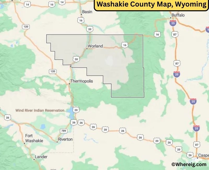
About Washakie County Map, Alabama: The map showing the county boundary, county seat, major cities, highways, water bodies and neighbouring counties.
Most Viewed Links
About Washakie County, Wyoming
Washakie County is located in the north-central part of Wyoming, United States. Established in 1911, the county was named after Chief Washakie of the Eastern Shoshone Tribe. The county seat and largest city is Worland, which serves as the primary commercial and agricultural center of the region. The county is known for its irrigated farmland and scenic landscapes along the Big Horn Basin.
Population
According to the United States Census Bureau, the population of Washakie County was 7,685 as recorded in the 2020 Census. The majority of residents live in Worland, with smaller communities supporting agriculture and local industries.
Area and Geography
According to the United States Census Bureau, Washakie County covers a total area of approximately 2,243 square miles, including about 2,239 square miles of land and 4 square miles of water. The county features portions of the Big Horn Basin, river valleys, and rolling plains typical of north-central Wyoming.
Bordering Counties
Washakie County shares borders with Big Horn County to the north, Johnson County to the east, Natrona County to the southeast, Fremont County to the south, and Hot Springs County to the west.
Major Cities and Communities
The principal communities in Washakie County include Worland and Ten Sleep, which serve as residential, agricultural, and recreational centers.
Attractions and Recreation
Washakie County offers outdoor recreation opportunities including hiking, fishing, camping, and exploring nearby canyon areas. The county’s agricultural lands and proximity to mountain ranges contribute to its scenic and rural character.
Transportation
Major transportation routes serving Washakie County include U.S. Highways 16, 20, and 789, providing connections to surrounding counties and other parts of Wyoming.
Explore more counties in Wyoming Counties or view the complete USA States Map section for additional geographic information.
Sources:
Population and area data sourced from the United States Census Bureau (2020 Census). General county information referenced from the Official Washakie County Government Website.
Facts about Washakie County, Wyoming
| Country | United States |
| State | Wyoming |
| Region | North-Central Wyoming |
| County Seat | Worland |
| Named After | Chief Washakie of the Shoshone Tribe |
| Established | 1911 |
| Organized | 1911 |
| Coordinates | 43.90° N, 107.68° W |
| Total Area | 2,243 sq mi |
| Land Area | 2,239 sq mi |
| Water Area | 4 sq mi |
| Population (2020) | 7,694 |
| Population Rank | Among the least populous counties in Wyoming |
| Largest Town | Worland |
| Main Industries | Agriculture, Food Processing, Government |
| Major Highways | U.S. Highway 20, U.S. Highway 16, State Highway 789 |
| Time Zone | Mountain Time (UTC−07:00) |
| Known For | Bighorn Basin agriculture, sugar beet production, irrigation farming |
| Official Website | https://www.washakiecountywy.gov |
Top Attractions in Washakie County, Wyoming
- Washakie County Courthouse – Historic courthouse.
- Historic Downtown Worland – Shops and dining.
- Big Horn Mountains Scenic Area – Hiking and wildlife.
- Washakie County Museum – Local history exhibits.
- Thermopolis Hot Springs (nearby) – Thermal pools and spa.
- Rural Scenic Roadways – Countryside drives.
- Community Parks – Picnic and recreation areas.
- Bighorn River – Fishing and boating.
- Wind River Canyon – Scenic river gorge.
- Outdoor Recreation Trails – Hiking and nature walks.
List of Cities and Towns in Washakie County, Wyoming
Worland, Ten Sleep, Meeteetse, Hyattville
- Albany County Map, WY
- Big Horn County Map, WY
- Campbell County Map, WY
- Carbon County Map, WY
- Converse County Map, WY
- Crook County Map, WY
- Fremont County Map, WY
- Goshen County Map, WY
- Hot Springs County Map, WY
- Johnson County Map, WY
- Laramie County Map, WY
- Lincoln County Map, WY
- Natrona County Map, WY
- Niobrara County Map, WY
- Park County Map, WY
- Platte County Map, WY
- Sheridan County Map, WY
- Sublette County Map, WY
- Sweetwater County Map, WY
- Teton County Map, WY
- Uinta County Map, WY
- Washakie County Map, WY
- Weston County Map, WY
- Alabama Counties
- Alaska boroughs
- Arizona Counties
- Arkansas Counties
- California County Map
- Colorado Counties
- Connecticut Counties
- Delaware Counties
- Florida County Map
- Georgia County Map
- Hawaii Counties
- Idaho Counties
- Illinois Counties
- Indiana Counties
- Iowa Counties
- Kansas Counties
- Kentucky Counties
- Louisiana Counties
- Maine Counties
- Maryland Counties
- Massachusetts Counties
- Michigan County Map
- Minnesota Counties
- Mississippi Counties
- Missouri Counties
- Montana Counties
- Nebraska Counties
- Nevada Counties
- New York Counties
- New Hampshire Counties
- New Jersey Counties
- New Mexico Counties
- North Carolina Counties
- North Dakota Counties
- Ohio County Map
- Oklahoma Counties
- Oregon Counties
- Pennsylvania Counties
- Rhode Island Counties
- South Carolina Counties
- South Dakota Counties
- Map of Tennessee
- Texas County Map
- Utah Counties
- Vermont Counties
- Virginia Counties
- Washington Counties
- West Virginia Counties
- Wisconsin Counties
- Wyoming Counties