Map of Sweetwater County - Sweetwater County is a county located in the U.S. state of Wyoming. Sweetwater County Map showing cities, highways, important places and water bodies. Get Where is Sweetwater County located in the map, major cities in Sweetwater county, population, areas, and places of interest.
Map of Sweetwater County, Wyoming
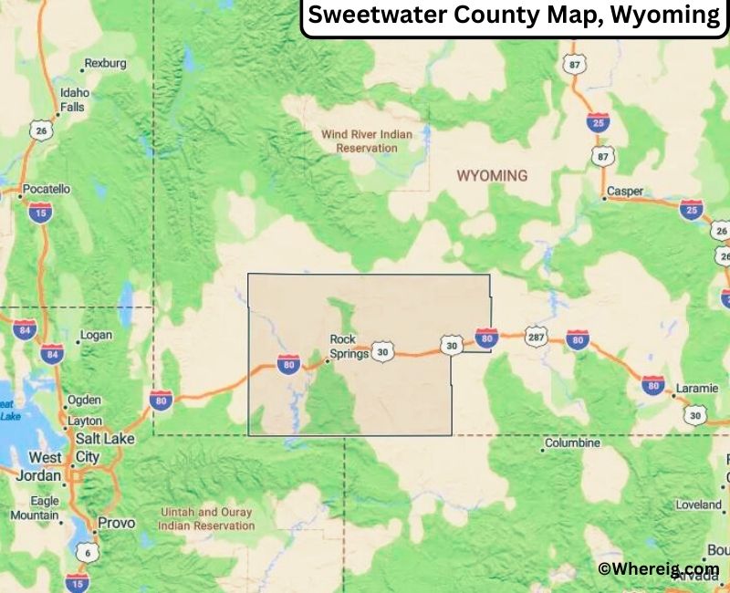
About Sweetwater County Map, Alabama: The map showing the county boundary, county seat, major cities, highways, water bodies and neighbouring counties.
Most Viewed Links
About Sweetwater County, Wyoming
Sweetwater County is located in the southwestern part of Wyoming, United States. Established in 1867, it is one of the largest counties in the state and was named after the Sweetwater River. The county seat is Green River, while the largest city is Rock Springs, which serves as a major commercial and industrial center. The county has long been associated with mining, energy production, and western migration trails.
Population
According to the United States Census Bureau, the population of Sweetwater County was 42,272 as recorded in the 2020 Census. The majority of residents live in Rock Springs and Green River, with smaller communities spread across the county.
Area and Geography
According to the United States Census Bureau, Sweetwater County covers a total area of approximately 10,491 square miles, including about 10,427 square miles of land and 64 square miles of water. It is the largest county in Wyoming by area and features high desert landscapes, river valleys, and portions of the Green River Basin.
Bordering Counties
Sweetwater County shares borders with Sublette County to the north, Fremont County to the northeast, Carbon County to the east, the state of Colorado to the south, and the state of Utah to the southwest.
Major Cities and Communities
The principal communities in Sweetwater County include Rock Springs, Green River, and Point of Rocks, which serve as residential, industrial, and transportation hubs.
Attractions and Recreation
Sweetwater County offers outdoor recreation including boating, fishing, hiking, and off-road exploration. Flaming Gorge National Recreation Area and the Green River attract visitors for water sports and scenic canyon views, while historic trails reflect the county’s pioneer past.
Transportation
Major transportation routes serving Sweetwater County include Interstate 80 and U.S. Highway 191, providing key east-west connectivity across southern Wyoming and linking the county to neighboring states.
Explore more counties in Wyoming Counties or view the complete USA States Map section for additional geographic information.
Sources:
Population and area data sourced from the United States Census Bureau (2020 Census). General county information referenced from the Official Sweetwater County Government Website.
Facts about Sweetwater County, Wyoming
| Country | United States |
| State | Wyoming |
| Region | Southwestern Wyoming |
| County Seat | Green River |
| Named After | Sweetwater River |
| Established | 1869 |
| Organized | 1869 |
| Coordinates | 41.66° N, 108.88° W |
| Total Area | 10,491 sq mi |
| Land Area | 10,426 sq mi |
| Water Area | 65 sq mi |
| Population (2020) | 42,343 |
| Population Rank | Fourth most populous county in Wyoming |
| Largest City | Rock Springs |
| Main Industries | Energy, Mining, Transportation, Manufacturing |
| Major Highways | Interstate 80, U.S. Highway 191, U.S. Highway 30 |
| Time Zone | Mountain Time (UTC−07:00) |
| Known For | Green River Basin, energy resources, Rock Springs |
| Official Website | https://www.sweetwatercountywy.gov |
Top Attractions in Sweetwater County, Wyoming
- Fossil Butte National Monument – Fossil exhibits and trails.
- Sweetwater County Courthouse – Historic courthouse.
- Historic Downtown Rock Springs – Shops and dining.
- Flaming Gorge National Recreation Area – Boating and fishing.
- Red Desert – Scenic landscapes and wildlife.
- Rural Scenic Roadways – Countryside drives.
- Community Parks – Picnic and recreation areas.
- Lincoln Monument – Historic landmark.
- White Mountain Petroglyphs – Ancient rock carvings.
- Bridger Valley – Outdoor activities and trails.
List of Cities and Towns in Sweetwater County, Wyoming
Rock Springs, Green River, Farson, Granger, Superior, Reliance, Wamsutter
- Albany County Map, WY
- Big Horn County Map, WY
- Campbell County Map, WY
- Carbon County Map, WY
- Converse County Map, WY
- Crook County Map, WY
- Fremont County Map, WY
- Goshen County Map, WY
- Hot Springs County Map, WY
- Johnson County Map, WY
- Laramie County Map, WY
- Lincoln County Map, WY
- Natrona County Map, WY
- Niobrara County Map, WY
- Park County Map, WY
- Platte County Map, WY
- Sheridan County Map, WY
- Sublette County Map, WY
- Sweetwater County Map, WY
- Teton County Map, WY
- Uinta County Map, WY
- Washakie County Map, WY
- Weston County Map, WY
- Alabama Counties
- Alaska boroughs
- Arizona Counties
- Arkansas Counties
- California County Map
- Colorado Counties
- Connecticut Counties
- Delaware Counties
- Florida County Map
- Georgia County Map
- Hawaii Counties
- Idaho Counties
- Illinois Counties
- Indiana Counties
- Iowa Counties
- Kansas Counties
- Kentucky Counties
- Louisiana Counties
- Maine Counties
- Maryland Counties
- Massachusetts Counties
- Michigan County Map
- Minnesota Counties
- Mississippi Counties
- Missouri Counties
- Montana Counties
- Nebraska Counties
- Nevada Counties
- New York Counties
- New Hampshire Counties
- New Jersey Counties
- New Mexico Counties
- North Carolina Counties
- North Dakota Counties
- Ohio County Map
- Oklahoma Counties
- Oregon Counties
- Pennsylvania Counties
- Rhode Island Counties
- South Carolina Counties
- South Dakota Counties
- Map of Tennessee
- Texas County Map
- Utah Counties
- Vermont Counties
- Virginia Counties
- Washington Counties
- West Virginia Counties
- Wisconsin Counties
- Wyoming Counties