Map of Sublette County - Sublette County is a county located in the U.S. state of Wyoming. Sublette County Map showing cities, highways, important places and water bodies. Get Where is Sublette County located in the map, major cities in Sublette county, population, areas, and places of interest.
Map of Sublette County, Wyoming
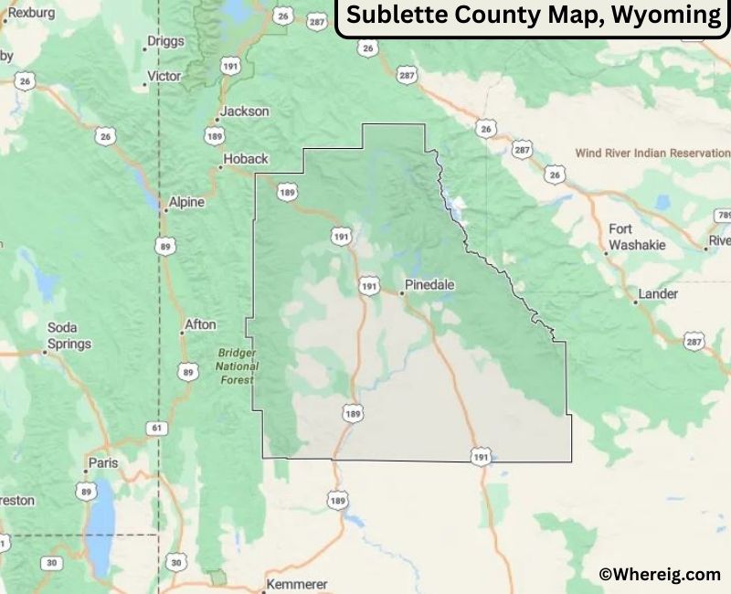
About Sublette County Map, Alabama: The map showing the county boundary, county seat, major cities, highways, water bodies and neighbouring counties.
Most Viewed Links
About Sublette County, Wyoming
Sublette County is located in the western part of Wyoming, United States. Established in 1921, the county was named after William L. Sublette, a mountain man and pioneer. The county seat and largest town is Pinedale, which serves as the primary commercial and administrative center. Sublette County is known for its expansive open spaces, mountain ranges, and strong ties to ranching and energy production.
Population
According to the United States Census Bureau, the population of Sublette County was 8,728 as recorded in the 2020 Census. The population is largely concentrated in Pinedale and Big Piney, with small rural communities throughout the county.
Area and Geography
According to the United States Census Bureau, Sublette County covers a total area of approximately 4,935 square miles, including about 4,887 square miles of land and 48 square miles of water. The county features portions of the Wind River Range, the Green River Basin, and vast public lands that define its rugged western landscape.
Bordering Counties
Sublette County shares borders with Teton County to the north, Fremont County to the east, Sweetwater County to the south, and Lincoln County to the west.
Major Cities and Communities
The principal communities in Sublette County include Pinedale, Big Piney, and Marbleton, which serve as residential, commercial, and recreational centers.
Attractions and Recreation
Sublette County offers extensive outdoor recreation opportunities including hiking, fishing, hunting, snowmobiling, and camping. The Wind River Range attracts climbers and backpackers, while the county’s rivers and forests provide year-round scenic and recreational value.
Transportation
Major transportation routes serving Sublette County include U.S. Highways 191 and 189, which connect the county to neighboring regions and facilitate travel across western Wyoming.
Explore more counties in Wyoming Counties or view the complete USA States Map section for additional geographic information.
Sources:
Population and area data sourced from the United States Census Bureau (2020 Census). General county information referenced from the Official Sublette County Government Website.
Facts about Sublette County, Wyoming
| Country | United States |
| State | Wyoming |
| Region | Western Wyoming |
| County Seat | Pinedale |
| Named After | Captain William Sublette |
| Established | 1921 |
| Organized | 1921 |
| Coordinates | 42.77° N, 109.91° W |
| Total Area | 4,936 sq mi |
| Land Area | 4,887 sq mi |
| Water Area | 49 sq mi |
| Population (2020) | 9,831 |
| Population Rank | Among the least populous counties in Wyoming |
| Largest Town | Pinedale |
| Main Industries | Energy, Agriculture, Tourism, Government |
| Major Highways | U.S. Highway 191, U.S. Highway 189, State Highway 352 |
| Time Zone | Mountain Time (UTC−07:00) |
| Known For | Wind River Range, natural gas fields, outdoor recreation |
| Official Website | https://www.sublettecountywy.gov |
Top Attractions in Sublette County, Wyoming
- Bridger-Teton National Forest – Hiking and wildlife.
- Sublette County Courthouse – Historic courthouse.
- Historic Downtown Pinedale – Shops and dining.
- Wind River Range – Scenic mountains and trails.
- Green River – Fishing and boating.
- Rural Scenic Roadways – Countryside drives.
- Community Parks – Picnic and recreation areas.
- Fossil Butte National Monument – Fossils and trails.
- Sublette County Museum – Local history exhibits.
- Trout Lake Recreation Area – Hiking and water activities.
List of Cities and Towns in Sublette County, Wyoming
Pinedale, Big Piney, Marbleton, Boulder
- Albany County Map, WY
- Big Horn County Map, WY
- Campbell County Map, WY
- Carbon County Map, WY
- Converse County Map, WY
- Crook County Map, WY
- Fremont County Map, WY
- Goshen County Map, WY
- Hot Springs County Map, WY
- Johnson County Map, WY
- Laramie County Map, WY
- Lincoln County Map, WY
- Natrona County Map, WY
- Niobrara County Map, WY
- Park County Map, WY
- Platte County Map, WY
- Sheridan County Map, WY
- Sublette County Map, WY
- Sweetwater County Map, WY
- Teton County Map, WY
- Uinta County Map, WY
- Washakie County Map, WY
- Weston County Map, WY
- Alabama Counties
- Alaska boroughs
- Arizona Counties
- Arkansas Counties
- California County Map
- Colorado Counties
- Connecticut Counties
- Delaware Counties
- Florida County Map
- Georgia County Map
- Hawaii Counties
- Idaho Counties
- Illinois Counties
- Indiana Counties
- Iowa Counties
- Kansas Counties
- Kentucky Counties
- Louisiana Counties
- Maine Counties
- Maryland Counties
- Massachusetts Counties
- Michigan County Map
- Minnesota Counties
- Mississippi Counties
- Missouri Counties
- Montana Counties
- Nebraska Counties
- Nevada Counties
- New York Counties
- New Hampshire Counties
- New Jersey Counties
- New Mexico Counties
- North Carolina Counties
- North Dakota Counties
- Ohio County Map
- Oklahoma Counties
- Oregon Counties
- Pennsylvania Counties
- Rhode Island Counties
- South Carolina Counties
- South Dakota Counties
- Map of Tennessee
- Texas County Map
- Utah Counties
- Vermont Counties
- Virginia Counties
- Washington Counties
- West Virginia Counties
- Wisconsin Counties
- Wyoming Counties