Map of Big Horn County - Big Horn County is a county located in the U.S. state of Wyoming. Big Horn County Map showing cities, highways, important places and water bodies. Get Where is Big Horn County located in the map, major cities in Big Horn county, population, areas, and places of interest.
Map of Big Horn County, Wyoming
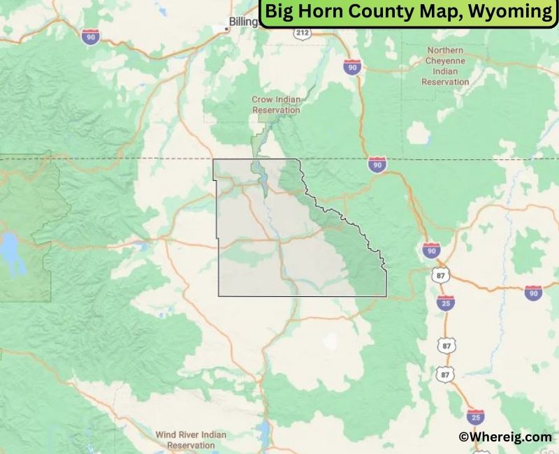
About Big Horn County Map, Alabama: The map showing the county boundary, county seat, major cities, highways, water bodies and neighbouring counties.
Most Viewed Links
About Big Horn County, Wyoming
Big Horn County is located in the north-central part of Wyoming, United States, along the border with Montana. Established in 1896, the county was named after the Bighorn River and the surrounding Bighorn Mountains. The county seat is Basin, while Worland is the largest city and serves as a commercial center for the region.
Population
According to the United States Census Bureau, the population of Big Horn County was 11,521 as recorded in the 2020 Census. The county includes small towns and rural communities, with many residents living in Worland and surrounding agricultural areas.
Area and Geography
According to the United States Census Bureau, Big Horn County covers a total area of approximately 3,159 square miles, including about 3,137 square miles of land and 22 square miles of water. The county features river valleys, farmland, and portions of the Bighorn Mountains that shape its landscape.
Bordering Counties
Big Horn County shares borders with Park County to the west, Hot Springs County to the south, Washakie County to the southeast, and Sheridan County to the east, while its northern boundary meets Montana.
Major Cities and Communities
The principal communities in Big Horn County include Worland, Basin, Greybull, and Lovell. Basin serves as the county seat, while Worland is the largest city and an important regional hub.
Attractions and Recreation
Big Horn County offers outdoor recreation opportunities including fishing, hiking, and camping in the Bighorn Mountains and along the Bighorn River. The region’s scenic landscapes and agricultural heritage attract visitors seeking nature-based experiences.
Transportation
Major transportation routes serving Big Horn County include U.S. Route 16, U.S. Route 20, and U.S. Route 310, connecting the county to other parts of Wyoming and neighboring Montana.
Explore more counties in Wyoming Counties or view the complete USA States Map section for additional geographic information.
Sources:
Population and area data sourced from the United States Census Bureau (2020 Census). General county information referenced from the Official Big Horn County Government Website.
Facts about Big Horn County, Wyoming
| Country | United States |
| State | Wyoming |
| Region | North-Central Wyoming |
| County Seat | Basin |
| Named After | Bighorn Mountains |
| Established | 1890 |
| Organized | 1890 |
| Coordinates | 44.53° N, 108.00° W |
| Total Area | 3,159 sq mi |
| Land Area | 3,137 sq mi |
| Water Area | 22 sq mi |
| Population (2020) | 11,521 |
| Population Rank | Mid-sized county in Wyoming |
| Largest City | Lovell |
| Main Industries | Agriculture, Energy, Government, Tourism |
| Major Highways | U.S. Highway 14, U.S. Highway 310, State Highway 789 |
| Time Zone | Mountain Time (UTC−07:00) |
| Known For | Bighorn Basin, agriculture, proximity to Bighorn Mountains |
| Official Website | https://www.bighorncountywy.gov |
Top Attractions in Big Horn County, Wyoming
- Bighorn Canyon National Recreation Area – Boating and hiking.
- Cloud Peak Wilderness – Mountain trails and scenery.
- Big Horn County Courthouse – Historic courthouse.
- Historic Downtown Basin – Shops and local dining.
- Shell Falls – Scenic waterfall and viewpoints.
- Medicine Lodge State Archaeological Site – Ancient rock art.
- Rural Scenic Roadways – Countryside drives.
- Big Horn Mountains – Hiking and wildlife viewing.
- Historic Fort Smith – Old frontier site.
- Lake DeSmet – Fishing and boating.
List of Cities and Towns in Big Horn County, Wyoming
Basin, Lovell, Greybull, Cowley, Byron, Manderson, Burlington, Hyattville
- Albany County Map, WY
- Big Horn County Map, WY
- Campbell County Map, WY
- Carbon County Map, WY
- Converse County Map, WY
- Crook County Map, WY
- Fremont County Map, WY
- Goshen County Map, WY
- Hot Springs County Map, WY
- Johnson County Map, WY
- Laramie County Map, WY
- Lincoln County Map, WY
- Natrona County Map, WY
- Niobrara County Map, WY
- Park County Map, WY
- Platte County Map, WY
- Sheridan County Map, WY
- Sublette County Map, WY
- Sweetwater County Map, WY
- Teton County Map, WY
- Uinta County Map, WY
- Washakie County Map, WY
- Weston County Map, WY
- Alabama Counties
- Alaska boroughs
- Arizona Counties
- Arkansas Counties
- California County Map
- Colorado Counties
- Connecticut Counties
- Delaware Counties
- Florida County Map
- Georgia County Map
- Hawaii Counties
- Idaho Counties
- Illinois Counties
- Indiana Counties
- Iowa Counties
- Kansas Counties
- Kentucky Counties
- Louisiana Counties
- Maine Counties
- Maryland Counties
- Massachusetts Counties
- Michigan County Map
- Minnesota Counties
- Mississippi Counties
- Missouri Counties
- Montana Counties
- Nebraska Counties
- Nevada Counties
- New York Counties
- New Hampshire Counties
- New Jersey Counties
- New Mexico Counties
- North Carolina Counties
- North Dakota Counties
- Ohio County Map
- Oklahoma Counties
- Oregon Counties
- Pennsylvania Counties
- Rhode Island Counties
- South Carolina Counties
- South Dakota Counties
- Map of Tennessee
- Texas County Map
- Utah Counties
- Vermont Counties
- Virginia Counties
- Washington Counties
- West Virginia Counties
- Wisconsin Counties
- Wyoming Counties