Map of Fremont County - Fremont County is a county located in the U.S. state of Wyoming. Fremont County Map showing cities, highways, important places and water bodies. Get Where is Fremont County located in the map, major cities in Fremont county, population, areas, and places of interest.
Map of Fremont County, Wyoming
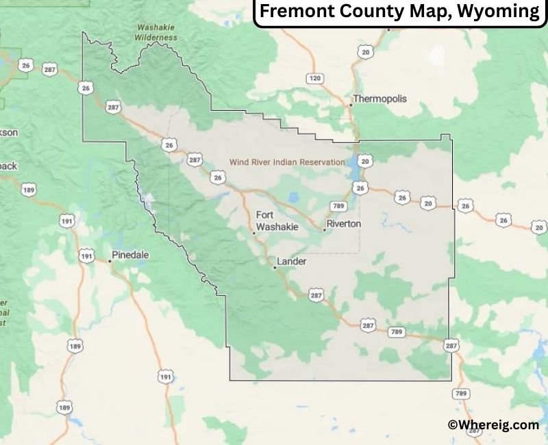
About Fremont County Map, Alabama: The map showing the county boundary, county seat, major cities, highways, water bodies and neighbouring counties.
Most Viewed Links
About Fremont County, Wyoming
Fremont County is located in the central part of Wyoming, United States. Established in 1884, the county was named after explorer John C. Frémont. The county seat is Lander, while Riverton serves as the largest city and an important commercial center. The county is known for its rich Native American heritage, expansive public lands, and diverse landscapes that include mountains, rivers, and high plains.
Population
According to the United States Census Bureau, the population of Fremont County was 39,261 as recorded in the 2020 Census. The population is concentrated in Riverton and Lander, along with smaller communities across the Wind River Basin.
Area and Geography
According to the United States Census Bureau, Fremont County covers a total area of approximately 9,266 square miles, including about 9,184 square miles of land and 82 square miles of water. It is one of the largest counties in Wyoming and features parts of the Wind River Range, the Wind River Indian Reservation, and significant stretches of forest and wilderness areas.
Bordering Counties
Fremont County shares borders with Park County to the north, Hot Springs County to the northeast, Washakie County to the east, Natrona County to the southeast, Converse County to the south, Sublette County to the west, and Teton County to the northwest.
Major Cities and Communities
The principal communities in Fremont County include Riverton and Lander, along with smaller towns such as Dubois and Shoshoni, which contribute to the county’s cultural and economic landscape.
Attractions and Recreation
Fremont County offers extensive outdoor recreation opportunities including hiking, fishing, camping, and mountaineering. The Wind River Range attracts outdoor enthusiasts, while historic trails and cultural sites reflect the region’s Native American and pioneer heritage.
Transportation
Major transportation routes serving Fremont County include U.S. Routes 20, 26, and 287, providing connections to central Wyoming and neighboring regions.
Explore more counties in Wyoming Counties or view the complete USA States Map section for additional geographic information.
Sources:
Population and area data
Facts about Fremont County, Wyoming
| Country | United States |
| State | Wyoming |
| Region | Central Wyoming |
| County Seat | Lander |
| Named After | John C. Frémont |
| Established | 1884 |
| Organized | 1884 |
| Coordinates | 43.04° N, 108.63° W |
| Total Area | 9,266 sq mi |
| Land Area | 9,184 sq mi |
| Water Area | 82 sq mi |
| Population (2020) | 40,528 |
| Population Rank | Second most populous county in Wyoming |
| Largest City | Riverton |
| Main Industries | Agriculture, Energy, Healthcare, Government |
| Major Highways | U.S. Highway 26, U.S. Highway 287, U.S. Highway 789 |
| Time Zone | Mountain Time (UTC−07:00) |
| Known For | Wind River Range, Wind River Indian Reservation, outdoor recreation |
| Official Website | https://www.fremontcountywy.gov |
Top Attractions in Fremont County, Wyoming
- Wind River Canyon – Scenic river gorge and views.
- Fremont County Courthouse – Historic courthouse.
- Historic Downtown Lander – Shops and dining.
- Sinks Canyon State Park – Trails and waterfalls.
- Shoshone National Forest – Hiking and wildlife.
- Rural Scenic Roadways – Countryside drives.
- Fremont County Museum – Local history exhibits.
- Boysen Reservoir – Boating and fishing.
- Community Parks – Picnic and recreation areas.
- Wind River Mountains – Scenic hikes and views.
List of Cities and Towns in Fremont County, Wyoming
Riverton, Lander, Dubois, Shoshoni, Hudson, Pavillion, Jeffrey City, Kinnear
- Albany County Map, WY
- Big Horn County Map, WY
- Campbell County Map, WY
- Carbon County Map, WY
- Converse County Map, WY
- Crook County Map, WY
- Fremont County Map, WY
- Goshen County Map, WY
- Hot Springs County Map, WY
- Johnson County Map, WY
- Laramie County Map, WY
- Lincoln County Map, WY
- Natrona County Map, WY
- Niobrara County Map, WY
- Park County Map, WY
- Platte County Map, WY
- Sheridan County Map, WY
- Sublette County Map, WY
- Sweetwater County Map, WY
- Teton County Map, WY
- Uinta County Map, WY
- Washakie County Map, WY
- Weston County Map, WY
- Alabama Counties
- Alaska boroughs
- Arizona Counties
- Arkansas Counties
- California County Map
- Colorado Counties
- Connecticut Counties
- Delaware Counties
- Florida County Map
- Georgia County Map
- Hawaii Counties
- Idaho Counties
- Illinois Counties
- Indiana Counties
- Iowa Counties
- Kansas Counties
- Kentucky Counties
- Louisiana Counties
- Maine Counties
- Maryland Counties
- Massachusetts Counties
- Michigan County Map
- Minnesota Counties
- Mississippi Counties
- Missouri Counties
- Montana Counties
- Nebraska Counties
- Nevada Counties
- New York Counties
- New Hampshire Counties
- New Jersey Counties
- New Mexico Counties
- North Carolina Counties
- North Dakota Counties
- Ohio County Map
- Oklahoma Counties
- Oregon Counties
- Pennsylvania Counties
- Rhode Island Counties
- South Carolina Counties
- South Dakota Counties
- Map of Tennessee
- Texas County Map
- Utah Counties
- Vermont Counties
- Virginia Counties
- Washington Counties
- West Virginia Counties
- Wisconsin Counties
- Wyoming Counties