Map of Goshen County - Goshen County is a county located in the U.S. state of Wyoming. Goshen County Map showing cities, highways, important places and water bodies. Get Where is Goshen County located in the map, major cities in Goshen county, population, areas, and places of interest.
Map of Goshen County, Wyoming
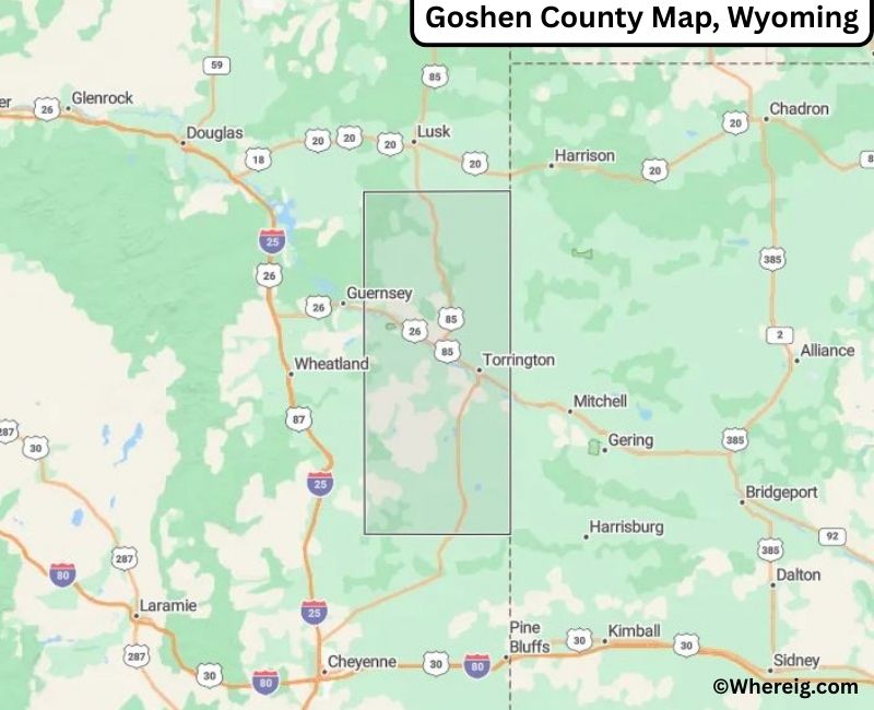
About Goshen County Map, Alabama: The map showing the county boundary, county seat, major cities, highways, water bodies and neighbouring counties.
Most Viewed Links
About Goshen County, Wyoming
Goshen County is located in the southeastern part of Wyoming, United States. Established in 1911, the county was named after the biblical Land of Goshen. The county seat and largest city is Torrington, which serves as the primary commercial and agricultural center of the region. The county is known for its ranching, farming, and strong rural heritage along the North Platte River Valley.
Population
According to the United States Census Bureau, the population of Goshen County was 12,784 as recorded in the 2020 Census. The population is largely concentrated in Torrington, with smaller communities supporting agriculture and local industries.
Area and Geography
According to the United States Census Bureau, Goshen County covers a total area of approximately 2,225 square miles, including about 2,220 square miles of land and 5 square miles of water. The county features rolling plains, fertile river valleys, and irrigation-supported farmland typical of southeastern Wyoming.
Bordering Counties
Goshen County shares borders with Niobrara County to the north, Platte County to the west, Laramie County to the south, and the state of Nebraska to the east.
Major Cities and Communities
The principal communities in Goshen County include Torrington, Fort Laramie, Lingle, and LaGrange, which contribute to the county’s agricultural economy and community life.
Attractions and Recreation
Goshen County offers outdoor recreation opportunities including fishing, boating, and camping along the North Platte River. Historic sites such as Fort Laramie National Historic Site highlight the county’s role in westward expansion and frontier history.
Transportation
Major transportation routes serving Goshen County include U.S. Routes 26 and 85, providing connectivity to neighboring counties and the state of Nebraska.
Explore more counties in Wyoming Counties or view the complete USA States Map section for additional geographic information.
Sources:
Population and area data sourced from the United States Census Bureau (2020 Census). General county information referenced from the Official Goshen County Government Website.
Facts about Goshen County, Wyoming
| Country | United States |
| State | Wyoming |
| Region | Southeastern Wyoming |
| County Seat | Torrington |
| Named After | Biblical Land of Goshen |
| Established | 1911 |
| Organized | 1911 |
| Coordinates | 42.13° N, 104.36° W |
| Total Area | 2,228 sq mi |
| Land Area | 2,221 sq mi |
| Water Area | 7 sq mi |
| Population (2020) | 13,272 |
| Population Rank | Mid-sized county in Wyoming |
| Largest City | Torrington |
| Main Industries | Agriculture, Food Processing, Government |
| Major Highways | U.S. Highway 26, U.S. Highway 85, State Highway 92 |
| Time Zone | Mountain Time (UTC−07:00) |
| Known For | High Plains agriculture, North Platte River Valley, irrigation farming |
| Official Website | https://www.goshencountywy.gov |
Top Attractions in Goshen County, Wyoming
- Goshen County Courthouse – Historic courthouse.
- Historic Downtown Torrington – Shops and dining.
- Torrington Lake Park – Boating and fishing.
- Trail End State Historic Site – Historic mansion and museum.
- Rural Scenic Roadways – Countryside drives.
- Grayrocks Reservoir – Fishing and water recreation.
- Goshen County Museum – Local history exhibits.
- Community Parks – Picnic and recreation areas.
- High Plains Scenic Areas – Countryside views.
- Historic Windmill Sites – Early settlement landmarks.
List of Cities and Towns in Goshen County, Wyoming
Torrington, Lingle, La Grange, Yoder, Veteran, Huntley
- Albany County Map, WY
- Big Horn County Map, WY
- Campbell County Map, WY
- Carbon County Map, WY
- Converse County Map, WY
- Crook County Map, WY
- Fremont County Map, WY
- Goshen County Map, WY
- Hot Springs County Map, WY
- Johnson County Map, WY
- Laramie County Map, WY
- Lincoln County Map, WY
- Natrona County Map, WY
- Niobrara County Map, WY
- Park County Map, WY
- Platte County Map, WY
- Sheridan County Map, WY
- Sublette County Map, WY
- Sweetwater County Map, WY
- Teton County Map, WY
- Uinta County Map, WY
- Washakie County Map, WY
- Weston County Map, WY
- Alabama Counties
- Alaska boroughs
- Arizona Counties
- Arkansas Counties
- California County Map
- Colorado Counties
- Connecticut Counties
- Delaware Counties
- Florida County Map
- Georgia County Map
- Hawaii Counties
- Idaho Counties
- Illinois Counties
- Indiana Counties
- Iowa Counties
- Kansas Counties
- Kentucky Counties
- Louisiana Counties
- Maine Counties
- Maryland Counties
- Massachusetts Counties
- Michigan County Map
- Minnesota Counties
- Mississippi Counties
- Missouri Counties
- Montana Counties
- Nebraska Counties
- Nevada Counties
- New York Counties
- New Hampshire Counties
- New Jersey Counties
- New Mexico Counties
- North Carolina Counties
- North Dakota Counties
- Ohio County Map
- Oklahoma Counties
- Oregon Counties
- Pennsylvania Counties
- Rhode Island Counties
- South Carolina Counties
- South Dakota Counties
- Map of Tennessee
- Texas County Map
- Utah Counties
- Vermont Counties
- Virginia Counties
- Washington Counties
- West Virginia Counties
- Wisconsin Counties
- Wyoming Counties