
Where is Frederica Located? - Frederica is a city located in the Kent County of Delaware, United States. Frederica lies between 31.8315 Degrees North latitudes and 81.6141 Degrees West longitudes.
Location Map of Frederica, Delaware
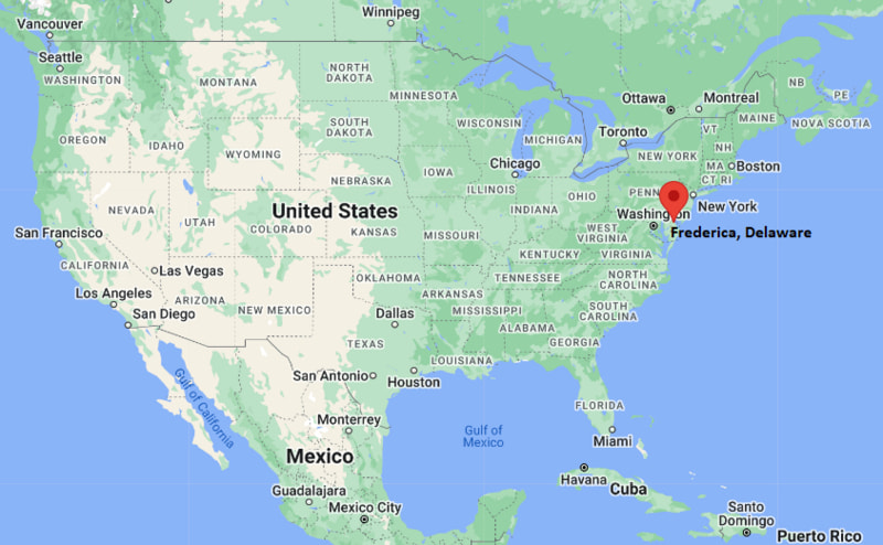
Frederica Map, Delaware, USA
Where is Frederica?: The Google Map showing the location of Frederica in the U.S. state of Delaware.
Where is Frederica Located?
Frederica is a city located in the Kent County of Delaware, United States. Frederica lies between 31.8315 Degrees North latitudes and 81.6141 Degrees West longitudes. According to 2020 U.S.census, the population of Frederica city is 1073 people and the city has a total area of 1.74 sq mi. The city has numerous parks and recreational facilities.
Most Viewed US Maps
| USA Sttae Map | USA Region Map | USA Road Map |
| USA County Map | Where is USA in World Map? | US ZIP Code Map |
| USA Time Zones Map | US State and Capitals Map | USA Physical Map |
Find 4,400+ U.S. Cities by State - Explore Their Locations and Get Detailed Information
Frederica, Delaware Quick Facts
| Property | Information |
|---|---|
| City | Frederica |
| County | Kent County |
| State | Delaware |
| State Capital | Dover |
| US Region | South |
| Latitude | 39.0098°N |
| Longitude | 75.4652°W |
| Elevation | 23 ft (7 m) |
| Land Area | 0.78 sq mi |
| Water Area | 0.02 sq mi |
| Total Area | 0.80 sq mi |
| Population (2020 Census) | 774 |
| Population Density | 992 per sq mi |
| ZIP Codes | 19946 |
| Area Code | 302 |
| Time Zone Standard | Eastern Standard Time (EST, UTC−5) |
| Time Zone Daylight | Eastern Daylight Time (EDT, UTC−4) |
| Currency | United States Dollar (USD) |
| FIPS Code | 10-29130 |
| Congressional District | Delaware At-Large Congressional District |
Nearby Cities to Frederica, Delaware
- Felton, Delaware - West - 6 mi
- Camden, Delaware - Northwest - 10 mi
- Dover, Delaware - North - 12 mi
- Milford, Delaware - South - 13 mi
- Harrington, Delaware - Southwest - 15 mi
- Houston, Delaware - West - 8 mi
- Bowers, Delaware - Northeast - 9 mi
- Magnolia, Delaware - North - 7 mi
- Viola, Delaware - West - 11 mi
- Lewes, Delaware - Southeast - 38 mi
Driving Distances from Frederica, Delaware
| City | State | Distance (mi) | Approx. Drive Time |
|---|---|---|---|
| Felton | Delaware | 6 | 10 minutes |
| Magnolia | Delaware | 7 | 10 minutes |
| Houston | Delaware | 8 | 12 minutes |
| Bowers | Delaware | 9 | 15 minutes |
| Camden | Delaware | 10 | 15 minutes |
| Viola | Delaware | 11 | 18 minutes |
| Dover | Delaware | 12 | 20 minutes |
| Milford | Delaware | 13 | 20 minutes |
| Harrington | Delaware | 15 | 22 minutes |
| Lewes | Delaware | 38 | 50 minutes |
Transportation and Connectivity in Frederica, Delaware
| Mode | Details |
|---|---|
| Airport Name | Delaware Coastal Airport (nearest public airport) |
| IATA Code | GED |
| Port | Frederica River public boat access |
| Major Highways | Delaware Route 1, Delaware Route 12, Delaware Route 36 |
| Train/Amtrak Service | Nearest Amtrak station is Wilmington, Delaware |
| Local Bus/Transit Service | DART First State regional bus service (nearby) |
- Delaware Route 1 is the primary north-south highway connecting Frederica with Dover, Wilmington, and Delaware's beach communities.
- Delaware Route 12 links Frederica with Felton, Harrington, and western Kent County.
- Delaware Route 36 provides local access between Frederica, Milford, and nearby communities along the Delaware Bay region.
What are top Places to Visit in Frederica, Delaware
| Landmark Name | Type |
|---|---|
| Barratt's Chapel | Historic Site |
| Frederica Historic District | Historic District |
| Killens Pond State Park | State Park |
| Bowers Beach | Beach |
| John Dickinson Plantation | Historic Site |
| Delaware Agricultural Museum and Village | Museum |
| Abbott's Mill Nature Center | Nature Center |
| DE Turf Sports Complex | Sports Complex |
| Prime Hook National Wildlife Refuge | Wildlife Refuge |
| Tidbury Creek Park | Park |
Colleges and Universities in Frederica, Delaware
| Institution Name | Type | Level | Notable For |
|---|---|---|---|
| Delaware State University | Public | University | Land-grant research university |
| Wesley College (DSU Downtown Campus) | Public | University | Liberal arts and professional studies |
| Delaware Technical Community College – Terry Campus | Public | Community College | Career and workforce education |
| Wilmington University – Dover Campus | Private | University | Adult and online education |
| Lake Forest School District | Public | K–12 District | Public education serving Frederica |
Waterbodies in Frederica, Delaware
Frederica River, Murderkill River, Delaware Bay, Bowers Beach Marsh, Spring Branch, Pratt Branch, Coursey Pond, Killens Pond
Golf Courses in Frederica, Delaware
Jonathan's Landing Golf Club, Maple Dale Country Club, Wild Quail Golf & Country Club, Rookery Golf Club, Southern Meadows Golf Club, Shawnee Country Club
Frederica, Delaware — Key Historical Facts
- Frederica was established in the eighteenth century as a small port town along the Frederica River, supporting trade and shipbuilding in central Delaware.
- The town was officially incorporated in 1826 and developed as a commercial center for surrounding agricultural communities.
- Its location near the Murderkill and Frederica rivers helped support local commerce, fishing, and transportation during the nineteenth century.
- Several historic buildings within the Frederica Historic District reflect the town's colonial and early American architectural heritage.
- Today, Frederica is known for its quiet historic character, proximity to Delaware Bay, and convenient access to Dover and Delaware's coastal attractions.
References
Delaware Maps and Info
- Where is Bear
- Where is Bellefonte
- Where is Blades
- Where is Bridgeville
- Where is Brookside
- Where is Camden
- Where is Cheswold
- Where is Claymont
- Where is Clayton
- Where is Delaware City
- Where is Delmar
- Where is Dover
- Where is Dover Base Housing
- Where is Edgemoor
- Where is Elsmere
- Where is Felton
- Where is Frederica
- Where is Georgetown
- Where is Glasgow
- Where is Greenville
- Where is Harrington
- Where is Highland Acres
- Where is Hockessin
- Where is Kent Acres
- Where is Laurel
- Where is Lewes
- Where is Long Neck
- Where is Middletown
- Where is Milford
- Where is Millsboro
- Where is Millville
- Where is Milton
- Where is New Castle
- Where is North Star
- Where is Ocean View
- Where is Pike Creek
- Where is Pike Creek Valley
- Where is Rehoboth Beach
- Where is Rising Sun-Lebanon
- Where is Riverview
- Where is Rodney Village
- Where is Seaford
- Where is Selbyville
- Where is Smyrna
- Where is Townsend
- Where is Wilmington
- Where is Wilmington Manor
- Where is Woodside East
- Where is Wyoming