
Where is Rising Sun-Lebanon Located? - Rising Sun-Lebanon is a city located in the Kent County of Delaware, United States. Rising Sun-Lebanon lies between 29.2108 Degrees North latitudes and 81.0228 Degrees West longitudes.
Location Map of Rising Sun-Lebanon, Delaware
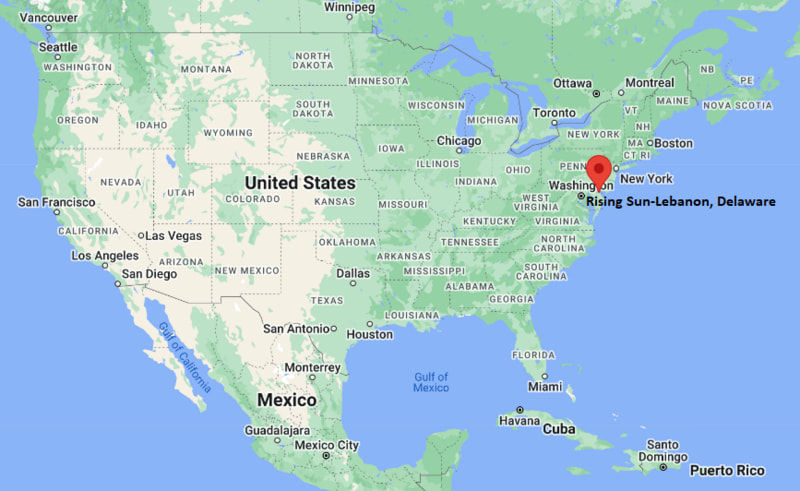
Rising Sun-Lebanon Map, Delaware, USA
Where is Rising Sun-Lebanon?: The Google Map showing the location of Rising Sun-Lebanon in the U.S. state of Delaware.
Where is Rising Sun-Lebanon Located?
Rising Sun-Lebanon is a city located in the Kent County of Delaware, United States. Rising Sun-Lebanon lies between 29.2108 Degrees North latitudes and 81.0228 Degrees West longitudes. According to 2020 U.S.census, the population of Rising Sun-Lebanon city is 4104 people and the city has a total area of 3.57 sq mi. The city has numerous parks and recreational facilities.
Most Viewed US Maps
| USA Sttae Map | USA Region Map | USA Road Map |
| USA County Map | Where is USA in World Map? | US ZIP Code Map |
| USA Time Zones Map | US State and Capitals Map | USA Physical Map |
Find 4,400+ U.S. Cities by State - Explore Their Locations and Get Detailed Information
Rising Sun-Lebanon, Delaware Quick Facts
| Attribute | Details |
|---|---|
| City | Rising Sun-Lebanon |
| County | Kent County |
| State | Delaware |
| State Capital | Dover |
| US Region | Northeast |
| Latitude | 39.0998° N |
| Longitude | 75.5050° W |
| Elevation | 26 ft (8 m) |
| Land Area | 3.57 sq mi |
| Water Area | 0.03 sq mi |
| Total Area | 3.61 sq mi |
| Population (2020 Census) | 4,104 |
| Population Density | 1,148 per sq mi |
| ZIP Codes | 19901 |
| Area Code | 302 |
| Time Zone Standard | Eastern Standard Time (EST), UTC−5 |
| Time Zone Daylight | Eastern Daylight Time (EDT), UTC−4 |
| Currency | United States Dollar (USD) |
| FIPS Code | 10-61265 |
| Congressional District | Delaware's At-Large Congressional District |
Transportation and Connectivity in Rising Sun-Lebanon, Delaware
| Transportation Type | Details |
|---|---|
| Airport Name | Dover Air Force Base Airport / Philadelphia International Airport |
| IATA Code | DOF / PHL |
| Port | Port of Wilmington and Delaware River port facilities |
| Major Highways | U.S. Route 13, U.S. Route 113, Delaware Route 1, Delaware Route 10 |
| Train/Amtrak Service | Amtrak service available at Wilmington Station |
| Local Bus/Transit Service | DART First State bus service provides regional connections in Kent County |
- U.S. Route 13: Runs north-south through Kent County and connects Rising Sun-Lebanon with Dover and communities across Delaware.
- U.S. Route 113: Provides regional access between central Delaware and the Delmarva Peninsula.
- Delaware Route 1: A major highway connecting Dover, Wilmington, and coastal Delaware destinations.
- Delaware Route 10: Provides local connections between southern Dover areas and nearby communities.
Top Places to Visit in Rising Sun-Lebanon, Delaware
| Landmark Name | Type |
|---|---|
| Delaware Agricultural Museum and Village | Museum |
| Biggs Museum of American Art | Art Museum |
| First State Heritage Park | Historic Park |
| John Dickinson Plantation | Historic Site |
| Silver Lake Park | Community Park |
| Dover Green Historic District | Historic District |
| Bombay Hook National Wildlife Refuge | Wildlife Refuge |
| Killens Pond State Park | State Park |
| Dover International Speedway | Sports Facility |
| Air Mobility Command Museum | Aviation Museum |
Driving Distances from Rising Sun-Lebanon, Delaware to Nearby Cities
| City | State | Distance (mi) | Approx. Drive Time |
|---|---|---|---|
| Dover | Delaware | 5 mi | 10 minutes |
| Smyrna | Delaware | 15 mi | 20 minutes |
| Milford | Delaware | 25 mi | 35 minutes |
| Harrington | Delaware | 30 mi | 40 minutes |
| Wilmington | Delaware | 75 mi | 1 hour 20 minutes |
| Newark | Delaware | 80 mi | 1 hour 25 minutes |
| Philadelphia | Pennsylvania | 85 mi | 1 hour 40 minutes |
| Baltimore | Maryland | 95 mi | 1 hour 45 minutes |
| Atlantic City | New Jersey | 95 mi | 2 hours |
| Washington, D.C. | District of Columbia | 110 mi | 2 hours 15 minutes |
Colleges and Universities Near Rising Sun-Lebanon, Delaware
| Institution Name | Type | Level | Notable For |
|---|---|---|---|
| Delaware State University | Public | University | Historically Black university, agriculture, education, and research programs |
| Delaware Technical Community College - Terry Campus | Public | Community College | Career training, technology, healthcare, and associate degrees |
| Wesley College (part of Delaware State University) | Public | University Campus | Professional programs and higher education opportunities |
| University of Delaware | Public | University | Research, engineering, business, and liberal arts programs |
| Wilmington University | Private | University | Business, education, technology, and professional studies |
| Caesar Rodney School District | Public | K–12 District | Primary and secondary education |
Waterbodies Near Rising Sun-Lebanon, Delaware
St. Jones River, Silver Lake, Tidbury Creek, Cypress Branch, Delaware Bay, and nearby waterways of Kent County.
Golf Courses Near Rising Sun-Lebanon
Jonathan's Landing Golf Course, Dover Country Club, Wild Quail Golf and Country Club, Maple Dale Country Club, and Jonathan's Landing Golf Links.
Rising Sun-Lebanon, Delaware — Key Historical Facts
- Rising Sun-Lebanon developed as a rural community in Kent County with roots connected to Delaware's agricultural history.
- The area grew near Dover, benefiting from the region's transportation routes and expanding suburban development.
- Rising Sun-Lebanon became recognized as a census-designated place through U.S. Census classification.
- The community has remained connected to the farming traditions and rural landscapes of central Delaware.
- Nearby Dover has played an important role in Delaware government, military history, and regional commerce.
- The area continues to reflect the historic character of Kent County while being close to modern services and attractions.
Stadiums and Sports Facilities Near Rising Sun-Lebanon
| Facility Name | Type | Location |
|---|---|---|
| Dover High School Stadium | High School Sports Stadium | Dover, Delaware |
| Frawley Stadium | Baseball Stadium | Wilmington, Delaware |
| Alumni Stadium - Delaware State University | College Sports Stadium | Dover, Delaware |
| Dover International Speedway | Motorsports Facility | Dover, Delaware |
| Bob Carpenter Center | College Sports Arena | Newark, Delaware |
References
- City of Dover Official Website
- Kent County Government
- U.S. Census Bureau
- Visit Delaware Tourism
- Delaware State University
Delaware Maps and Info
- Where is Bear
- Where is Bellefonte
- Where is Blades
- Where is Bridgeville
- Where is Brookside
- Where is Camden
- Where is Cheswold
- Where is Claymont
- Where is Clayton
- Where is Delaware City
- Where is Delmar
- Where is Dover
- Where is Dover Base Housing
- Where is Edgemoor
- Where is Elsmere
- Where is Felton
- Where is Frederica
- Where is Georgetown
- Where is Glasgow
- Where is Greenville
- Where is Harrington
- Where is Highland Acres
- Where is Hockessin
- Where is Kent Acres
- Where is Laurel
- Where is Lewes
- Where is Long Neck
- Where is Middletown
- Where is Milford
- Where is Millsboro
- Where is Millville
- Where is Milton
- Where is New Castle
- Where is North Star
- Where is Ocean View
- Where is Pike Creek
- Where is Pike Creek Valley
- Where is Rehoboth Beach
- Where is Rising Sun-Lebanon
- Where is Riverview
- Where is Rodney Village
- Where is Seaford
- Where is Selbyville
- Where is Smyrna
- Where is Townsend
- Where is Wilmington
- Where is Wilmington Manor
- Where is Woodside East
- Where is Wyoming