
Where is Lake Wylie Located? - Lake Wylie is a city located in the York County of South Carolina, United States. Lake Wylie lies between 35.5261633 Degrees North latitudes and 98.7075744 Degrees West longitudes.
Location Map of Lake Wylie, South Carolina
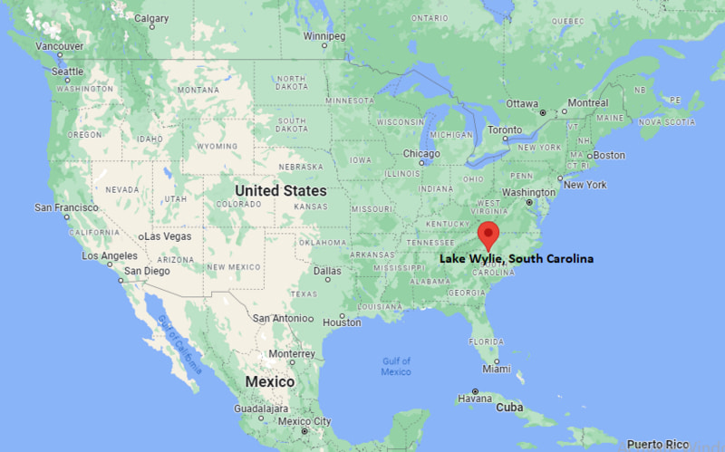
Lake Wylie Map, South Carolina, USA
Where is Lake Wylie?: The Google Map showing the location of Lake Wylie in the U.S. state of South Carolina.
Where is Lake Wylie Located?
Lake Wylie is a city located in the York County of South Carolina, United States. Lake Wylie lies between 35.5261633 Degrees North latitudes and 98.7075744 Degrees West longitudes. According to 2020 U.S.census, the population of Lake Wylie city is 13655 people and the city has a total area of 7.86 sq mi. The city has numerous parks and recreational facilities.
Most Viewed US Maps
| USA Sttae Map | USA Region Map | USA Road Map |
| USA County Map | Where is USA in World Map? | US ZIP Code Map |
| USA Time Zones Map | US State and Capitals Map | USA Physical Map |
Find 4,400+ U.S. Cities by State - Explore Their Locations and Get Detailed Information
Lake Wylie, South Carolina Quick Facts
| Property | Details |
|---|---|
| Census-Designated Place (CDP) | Lake Wylie |
| County | York County |
| State | South Carolina |
| State Capital | Columbia |
| US Region | Southeastern United States |
| Latitude | 35.1086° N |
| Longitude | 81.0436° W |
| Elevation | 581 ft (177 m) |
| Land Area | 8.46 sq mi |
| Water Area | 3.12 sq mi |
| Total Area | 11.58 sq mi |
| Population (2020 Census) | 13,655 |
| Population Density | Approximately 1,610 per sq mi |
| ZIP Code | 29710 |
| Area Code | 803 |
| Time Zone Standard | Eastern Standard Time (EST, UTC−5) |
| Time Zone Daylight | Eastern Daylight Time (EDT, UTC−4) |
| Currency | United States Dollar (USD) |
| FIPS Code | 45-39850 |
| Metropolitan Area | Charlotte–Concord–Gastonia Metropolitan Area |
Transportation and Connectivity in Lake Wylie
| Category | Details |
|---|---|
| Nearest Airport | Charlotte Douglas International Airport |
| IATA Code | CLT |
| Major Highways | South Carolina Highway 49, South Carolina Highway 274, U.S. Route 49 (nearby), Interstate 485 (nearby) |
| Public Transit | Limited regional transit; most travel is by private vehicle |
| Nearest Rail Service | Amtrak Station, Charlotte, North Carolina |
| Regional Access | Convenient access to Charlotte, Rock Hill, Gastonia, and the greater Charlotte metropolitan area |
- Charlotte Douglas International Airport: Located about 15 miles northeast, providing extensive domestic and international air service.
- SC Highways 49 and 274: Connect Lake Wylie with Rock Hill, Clover, Charlotte, and surrounding communities.
- Interstate Access: Nearby I-485 offers quick connections around the Charlotte metropolitan region.
- Regional Setting: Lake Wylie serves as a residential and recreational community with excellent access to both South Carolina and North Carolina destinations.
Top Places to Visit in Lake Wylie, South Carolina
| Landmark Name | Type |
|---|---|
| Lake Wylie | Reservoir & Recreation Area |
| Papa Doc's Shore Club | Lakeside Restaurant & Marina |
| Buster Boyd Bridge | Scenic Landmark |
| McDowell Nature Preserve (nearby) | Nature Preserve |
| Daniel Stowe Botanical Garden (nearby) | Botanical Garden |
| River Hills Marina | Marina |
| Allison Creek Park | County Park |
| Copperhead Island | Nature Area |
| Camp Thunderbird | Outdoor Recreation Center |
| Carowinds (nearby) | Theme Park |
Driving Distances from Lake Wylie, South Carolina to Nearby Cities
| City | State | Distance (mi) | Approx. Drive Time |
|---|---|---|---|
| Charlotte | North Carolina | 17 | 25 minutes |
| Rock Hill | South Carolina | 18 | 25 minutes |
| Clover | South Carolina | 11 | 20 minutes |
| Gastonia | North Carolina | 15 | 25 minutes |
| Belmont | North Carolina | 12 | 20 minutes |
| Fort Mill | South Carolina | 16 | 25 minutes |
| York | South Carolina | 23 | 35 minutes |
| Monroe | North Carolina | 37 | 50 minutes |
| Shelby | North Carolina | 40 | 55 minutes |
| Columbia | South Carolina | 92 | 1 hour 45 minutes |
Colleges and Universities in and near Lake Wylie, South Carolina
| Institution Name | Type | Level | Notable For |
|---|---|---|---|
| York Technical College | Public | Technical College | Career training, advanced manufacturing, healthcare, and workforce programs |
| Winthrop University | Public | University | Business, education, arts, sciences, and graduate programs |
| Gaston College | Public | Community College | Technical education, healthcare, engineering technologies, and transfer programs |
| University of North Carolina at Charlotte | Public | Research University | Engineering, business, computer science, healthcare, and research |
| Queens University of Charlotte | Private | University | Business, communications, nursing, and liberal arts |
Waterbodies in Lake Wylie, South Carolina
Lake Wylie, Catawba River, Allison Creek, Crowders Creek, Long Creek, South Fork Catawba River, Lake Wylie shoreline wetlands
Stadiums in Lake Wylie
River Hills Country Club Sports Facilities, Clover High School Stadium, York Comprehensive High School Stadium, Winthrop University Coliseum (nearby), Truist Field (Charlotte, nearby)
Lake Wylie, South Carolina — Key Historical Facts
- Lake Wylie developed around the Catawba River after the construction of the Lake Wylie reservoir by the Catawba Power Company in the early twentieth century.
- The lake was originally created for hydroelectric power generation and later became an important recreational resource for the region.
- The area grew from a rural lakeside community into a popular residential destination due to its proximity to Charlotte and the natural beauty of the reservoir.
- Lake Wylie has experienced significant population growth as part of the expanding Charlotte metropolitan area.
- Today, Lake Wylie is known for boating, fishing, waterfront neighborhoods, outdoor recreation, and its convenient location between South Carolina and North Carolina.
References
- York County Government
- U.S. Census Bureau
- Duke Energy
- York Technical College
- South Carolina State Parks
More South Carolina Maps & Info
- Where is Aiken
- Where is Anderson
- Where is Beaufort
- Where is Berea
- Where is Bluffton
- Where is Cayce
- Where is Charleston
- Where is Clemson
- Where is Columbia
- Where is Conway
- Where is Dentsville
- Where is Easley
- Where is Five Forks
- Where is Florence
- Where is Fort Mill
- Where is Gaffney
- Where is Gantt
- Where is Goose Creek
- Where is Greenville
- Where is Greenwood
- Where is Greer
- Where is Hanahan
- Where is Hilton Head Island
- Where is Ladson
- Where is Lake Wylie
- Where is Mauldin
- Where is Moncks Corner
- Where is Mount Pleasant
- Where is Myrtle Beach
- Where is North Augusta
- Where is North Charleston
- Where is North Myrtle Beach
- Where is Oak Grove
- Where is Orangeburg
- Where is Parker
- Where is Port Royal
- Where is Red Hill
- Where is Rock Hill
- Where is Seven Oaks
- Where is Simpsonville
- Where is Socastee
- Where is Spartanburg
- Where is St. Andrews
- Where is Summerville
- Where is Sumter
- Where is Taylors
- Where is Tega Cay
- Where is Wade Hampton
- Where is West Columbia