
Where is Gaffney Located? - Gaffney is a city located in the Cherokee County of South Carolina, United States. Gaffney lies between 35.1378441 Degrees North latitudes and 97.6580935 Degrees West longitudes.
Location Map of Gaffney, South Carolina
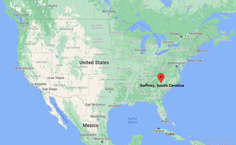
Gaffney Map, South Carolina, USA
Where is Gaffney?: The Google Map showing the location of Gaffney in the U.S. state of South Carolina.
Where is Gaffney Located?
Gaffney is a city located in the Cherokee County of South Carolina, United States. Gaffney lies between 35.1378441 Degrees North latitudes and 97.6580935 Degrees West longitudes. According to 2020 U.S.census, the population of Gaffney city is 12764 people and the city has a total area of 8.35 sq mi. The city has numerous parks and recreational facilities.
Most Viewed US Maps
| USA Sttae Map | USA Region Map | USA Road Map |
| USA County Map | Where is USA in World Map? | US ZIP Code Map |
| USA Time Zones Map | US State and Capitals Map | USA Physical Map |
Find 4,400+ U.S. Cities by State - Explore Their Locations and Get Detailed Information
Gadsden, South Carolina Quick Facts
| Property | Information |
|---|---|
| City | Gaffney |
| County | Cherokee County |
| State | South Carolina |
| State Capital | Columbia |
| US Region | South |
| Latitude | 35.0718°N |
| Longitude | 81.6498°W |
| Elevation | 827 ft (252 m) |
| Land Area | 8.37 sq mi |
| Water Area | 0.05 sq mi |
| Total Area | 8.42 sq mi |
| Population (2020 Census) | 12,539 |
| Population Density | 1,498 per sq mi |
| ZIP Codes | 29340, 29341, 29342 |
| Area Code | 864 |
| Time Zone Standard | Eastern Standard Time (EST, UTC−5) |
| Time Zone Daylight | Eastern Daylight Time (EDT, UTC−4) |
| Currency | United States Dollar (USD) |
| FIPS Code | 45-27970 |
| Congressional District | South Carolina's 3rd Congressional District |
Nearby Cities to Gaffney, South Carolina
- Blacksburg, South Carolina - Northeast - 10 mi
- Shelby, North Carolina - North - 17 mi
- Spartanburg, South Carolina - Southeast - 22 mi
- Kings Mountain, North Carolina - Northeast - 20 mi
- Boiling Springs, South Carolina - Southeast - 18 mi
- Gastonia, North Carolina - Northeast - 33 mi
- Forest City, North Carolina - Northwest - 28 mi
- Union, South Carolina - South - 32 mi
- York, South Carolina - East - 35 mi
- Charlotte, North Carolina - Northeast - 53 mi
Driving Distances from Gaffney, South Carolina
| City | State | Distance (mi) | Approx. Drive Time |
|---|---|---|---|
| Blacksburg | South Carolina | 10 | 15 minutes |
| Shelby | North Carolina | 17 | 20 minutes |
| Boiling Springs | South Carolina | 18 | 22 minutes |
| Kings Mountain | North Carolina | 20 | 25 minutes |
| Spartanburg | South Carolina | 22 | 25 minutes |
| Forest City | North Carolina | 28 | 35 minutes |
| Union | South Carolina | 32 | 40 minutes |
| Gastonia | North Carolina | 33 | 40 minutes |
| York | South Carolina | 35 | 45 minutes |
| Charlotte | North Carolina | 53 | 1 hour |
Transportation and Connectivity in Gaffney, South Carolina
| Mode | Details |
|---|---|
| Airport Name | Charlotte Douglas International Airport (nearest major airport) |
| IATA Code | CLT |
| Port | Not Applicable |
| Major Highways | Interstate 85, U.S. Highway 29, U.S. Highway 221, South Carolina Highway 18 |
| Train/Amtrak Service | Nearest Amtrak station is Spartanburg |
| Local Bus/Transit Service | Cherokee Area Transportation System (CATS) |
- Interstate 85 provides direct access to Charlotte, Spartanburg, Greenville, and Atlanta.
- U.S. Highway 29 runs through downtown Gaffney and connects neighboring communities across the Upstate region.
- U.S. Highway 221 links the city with Chesnee, Union, and western North Carolina.
- South Carolina Highway 18 provides regional access toward Shelby, North Carolina, and western Cherokee County.
What are top Places to Visit in Gaffney, South Carolina
| Landmark Name | Type |
|---|---|
| Peachoid Water Tower | Roadside Landmark |
| Cowpens National Battlefield | National Battlefield |
| Cherokee County History & Arts Museum | Museum |
| Lake Whelchel | Recreation Area |
| Henry J. Kaiser Park | City Park |
| Gaffney Outlet Marketplace | Shopping Center |
| Broad River Greenway | Nature Area |
| Kings Mountain National Military Park | Historic Park |
| Cherokee Speedway | Motorsports Venue |
| Limestone University Campus | Historic Campus |
Colleges and Universities in Gaffney, South Carolina
| Institution Name | Type | Level | Notable For |
|---|---|---|---|
| Limestone University | Private | University | Liberal arts, business, and education programs |
| Spartanburg Community College – Cherokee County Campus | Public | Community College | Technical education and workforce training |
| University of South Carolina Upstate | Public | University | Undergraduate and graduate education |
| Gardner-Webb University | Private | University | Liberal arts, health sciences, and business |
| Cherokee County School District | Public | K–12 District | Public education serving Gaffney |
Waterbodies in Gaffney, South Carolina
Broad River, Pacolet River, Lake Whelchel, Thicketty Creek, Kings Creek, Buffalo Creek, Cherokee Creek, Thickety Creek Reservoir
Golf Courses in Gaffney, South Carolina
Cherokee National Golf Club, Woodfin Ridge Golf Club, Carolina Country Club, Village Greens Golf Club, Cowpens Golf Club, Links O'Tryon Golf Club
Gaffney, South Carolina — Key Historical Facts
- Gaffney was established in the early nineteenth century and became the county seat of Cherokee County when the county was created in 1897.
- The city developed as an important textile manufacturing and agricultural center, benefiting from its location along major transportation routes.
- The arrival of the railroad and later Interstate 85 strengthened Gaffney's role as a regional commercial and distribution hub.
- The city's famous Peachoid Water Tower, built in 1981, became a widely recognized symbol of South Carolina's peach-growing heritage.
- Today, Gaffney is known for its educational institutions, manufacturing industries, historic downtown, and convenient location between Charlotte and Greenville.
References
More South Carolina Maps & Info
- Where is Aiken
- Where is Anderson
- Where is Beaufort
- Where is Berea
- Where is Bluffton
- Where is Cayce
- Where is Charleston
- Where is Clemson
- Where is Columbia
- Where is Conway
- Where is Dentsville
- Where is Easley
- Where is Five Forks
- Where is Florence
- Where is Fort Mill
- Where is Gaffney
- Where is Gantt
- Where is Goose Creek
- Where is Greenville
- Where is Greenwood
- Where is Greer
- Where is Hanahan
- Where is Hilton Head Island
- Where is Ladson
- Where is Lake Wylie
- Where is Mauldin
- Where is Moncks Corner
- Where is Mount Pleasant
- Where is Myrtle Beach
- Where is North Augusta
- Where is North Charleston
- Where is North Myrtle Beach
- Where is Oak Grove
- Where is Orangeburg
- Where is Parker
- Where is Port Royal
- Where is Red Hill
- Where is Rock Hill
- Where is Seven Oaks
- Where is Simpsonville
- Where is Socastee
- Where is Spartanburg
- Where is St. Andrews
- Where is Summerville
- Where is Sumter
- Where is Taylors
- Where is Tega Cay
- Where is Wade Hampton
- Where is West Columbia