
Where is Parker Located? - Parker is a city located in the Armstrong County of South Carolina, United States. Parker lies between 35.5223057 Degrees North latitudes and 97.6189809 Degrees West longitudes.
Location Map of Parker, South Carolina
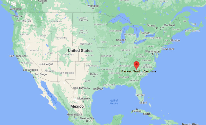
Parker Map, South Carolina, USA
Where is Parker?: The Google Map showing the location of Parker in the U.S. state of South Carolina.
Where is Parker Located?
Parker is a city located in the Greenville County of South Carolina, United States. Parker lies between 35.5223057 Degrees North latitudes and 97.6189809 Degrees West longitudes. According to 2020 U.S.census, the population of Parker city is 13407 people and the city has a total area of 6.84 sq mi. The city has numerous parks and recreational facilities.
Most Viewed US Maps
| USA Sttae Map | USA Region Map | USA Road Map |
| USA County Map | Where is USA in World Map? | US ZIP Code Map |
| USA Time Zones Map | US State and Capitals Map | USA Physical Map |
Find 4,400+ U.S. Cities by State - Explore Their Locations and Get Detailed Information
Parker, South Carolina Quick Facts
| Attribute | Details |
|---|---|
| City | Parker (Census-Designated Place) |
| County | Greenville County |
| State | South Carolina |
| State Capital | Columbia |
| US Region | Southern United States (South Atlantic) |
| Latitude | 34.8528° N |
| Longitude | 82.4539° W |
| Elevation | 968 ft (295 m) |
| Land Area | 2.33 sq mi |
| Water Area | 0.00 sq mi |
| Total Area | 2.33 sq mi |
| Population (2020 Census) | 11,122 |
| Population Density | Approximately 4,773 people per sq mi |
| ZIP Codes | 29611 |
| Area Code | 864 |
| Time Zone Standard | Eastern Standard Time (EST, UTC−5) |
| Time Zone Daylight | Eastern Daylight Time (EDT, UTC−4) |
| Currency | United States Dollar (USD) |
| FIPS Code | 45-54835 |
| Congressional District | South Carolina's 3rd Congressional District |
Transportation and Connectivity in Parker, South Carolina
| Category | Details |
|---|---|
| Airport Name | Greenville-Spartanburg International Airport |
| IATA Code | GSP |
| Port | No commercial port |
| Major Highways | Interstate 185, Interstate 85 (nearby), U.S. Route 123, U.S. Route 25 |
| Train/Amtrak Service | Nearest Amtrak station in Greenville |
| Local Bus/Transit Service | Greenlink Transit |
- Interstate 185 (I-185) – Provides direct access to downtown Greenville and Interstate 385.
- Interstate 85 (I-85) – Major regional interstate connecting the area with Atlanta, Charlotte, and the Upstate region.
- U.S. Route 123 – Connects Parker with Easley, Greenville, and northwestern South Carolina.
- U.S. Route 25 – Important north–south highway linking Greenville with Hendersonville, North Carolina, and Greenwood, South Carolina.
Top Places to Visit in Parker, South Carolina
| Landmark Name | Type |
|---|---|
| Falls Park on the Reedy | Urban Park |
| Fluor Field | Baseball Stadium |
| Peace Center | Performing Arts Center |
| Greenville County Museum of Art | Museum |
| Unity Park | Community Park |
| Swamp Rabbit Trail | Recreation Trail |
| Upcountry History Museum | Museum |
| Cleveland Park | Park |
| Paris Mountain State Park | State Park |
| Greenville Zoo | Zoo |
Driving Distances from Parker, South Carolina to Nearby Cities
| City | State | Distance (mi) | Approx. Drive Time |
|---|---|---|---|
| Greenville | South Carolina | 3 | 10 minutes |
| Easley | South Carolina | 8 | 15 minutes |
| Travelers Rest | South Carolina | 10 | 20 minutes |
| Mauldin | South Carolina | 8 | 15 minutes |
| Simpsonville | South Carolina | 13 | 20 minutes |
| Greer | South Carolina | 16 | 25 minutes |
| Spartanburg | South Carolina | 34 | 40 minutes |
| Anderson | South Carolina | 32 | 40 minutes |
| Asheville | North Carolina | 63 | 1 hour 15 minutes |
| Columbia | South Carolina | 104 | 1 hour 50 minutes |
Colleges and Universities in Parker, South Carolina
| Institution Name | Type | Level | Notable For |
|---|---|---|---|
| Greenville Technical College | Public | Technical College | Career and workforce education |
| Furman University | Private | University | Liberal arts and research programs |
| Bob Jones University | Private | University | Christian higher education |
| University of South Carolina Upstate | Public | University | Undergraduate and graduate education |
| Greenville County Schools | Public | K–12 District | Primary and secondary education |
Waterbodies in Parker, South Carolina
Reedy River, Saluda River, Brushy Creek, Enoree River, Lake Conestee, Lake Robinson, Saluda Lake, Table Rock Reservoir, Boyd Millpond, Lake Cunningham
Stadiums in Parker
Fluor Field, Sirrine Stadium, Eugene Stone Soccer Stadium, Bon Secours Wellness Arena, Furman University Golf Club, Green Valley Country Club, Greenville Country Club
Parker, South Carolina — Key Historical Facts
- Parker developed during the early twentieth century as a mill village supporting Greenville's thriving textile manufacturing industry.
- The community grew around Parker Mill, which provided employment and helped shape the area's residential development.
- As Greenville expanded after World War II, Parker became closely integrated with the city's growing metropolitan area.
- The decline of the textile industry led to redevelopment and diversification, transforming Parker into a primarily residential community.
- Today, Parker benefits from its location near downtown Greenville, offering convenient access to employment, education, parks, and cultural attractions.
References
- Greenville County Government
- U.S. Census Bureau
- Greenville Technical College
- Furman University
- VisitGreenvilleSC
More South Carolina Maps & Info
- Where is Aiken
- Where is Anderson
- Where is Beaufort
- Where is Berea
- Where is Bluffton
- Where is Cayce
- Where is Charleston
- Where is Clemson
- Where is Columbia
- Where is Conway
- Where is Dentsville
- Where is Easley
- Where is Five Forks
- Where is Florence
- Where is Fort Mill
- Where is Gaffney
- Where is Gantt
- Where is Goose Creek
- Where is Greenville
- Where is Greenwood
- Where is Greer
- Where is Hanahan
- Where is Hilton Head Island
- Where is Ladson
- Where is Lake Wylie
- Where is Mauldin
- Where is Moncks Corner
- Where is Mount Pleasant
- Where is Myrtle Beach
- Where is North Augusta
- Where is North Charleston
- Where is North Myrtle Beach
- Where is Oak Grove
- Where is Orangeburg
- Where is Parker
- Where is Port Royal
- Where is Red Hill
- Where is Rock Hill
- Where is Seven Oaks
- Where is Simpsonville
- Where is Socastee
- Where is Spartanburg
- Where is St. Andrews
- Where is Summerville
- Where is Sumter
- Where is Taylors
- Where is Tega Cay
- Where is Wade Hampton
- Where is West Columbia