Written and Fact-checked by Whereig Editors | Updated On: May 05, 2026 | 14:50 ET
Map of Greenville County - Greenville County is a county located in the U.S. state of South Carolina. Greenville County Map showing cities, highways, important places and water bodies. Get Where is Greenville County located in the map, major cities in Greenville county, population, areas, and places of interest.
Map of Greenville County, South Carolina
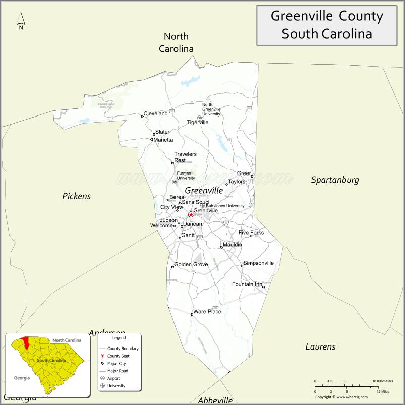
About Greenville County Map, South Carolina: The map showing the county boundary, county seat, major cities, highways, water bodies and neighbouring counties.
Related South Carolina Links
Map of Greenville County, South Carolina
Greenville County is a county located in the U.S. state of South Carolina. It's county seat is Greenville. As per 2020 census, the population of Greenville County is 533834 people and population density is square miles. According to the United States Census Bureau, the county has a total area of 795 sq mi (2,059 km2). Greenville County was established on 1786.
Greenville County Facts
| Continent | North America |
| Country | United States |
| State | South Carolina |
| County Seat | Greenville |
| Largest City/Town | Greenville |
| Established | 1786 |
| Total Area | 795.77 sq mi (2,061.01 sq km) |
| Land Area | 785.93 sq mi (2,035.56 sq km) |
| Water Area | 9.84 sq mi (25.45 sq km) |
| Population | 525,534 (Census 2020) |
| Population Density | 668.9 people per sq mi |
| Time Zone | Eastern (EST) |
| Major Highways | I-85, I-185, I-385, US-25, US-29, US-276 |
| Major Rivers | Reedy River, Saluda River |
| Neighboring Counties | Spartanburg, Pickens, Anderson, Laurens, Henderson (NC), Transylvania (NC) |
| Famous For | Downtown Greenville, Falls Park, manufacturing and tech growth |
| Top Attractions | Falls Park on the Reedy, Greenville Zoo, Paris Mountain State Park, Swamp Rabbit Trail |
| Official Website | Official Website |
About Greenville County, South Carolina
Greenville County is located in the northwestern part of South Carolina in the United States and was established in 1786. The county seat is Greenville, which is also the largest city. The county lies in the Upstate region and is known for its vibrant downtown, strong economy, scenic foothills of the Blue Ridge Mountains, and rapid population growth.
Cities and Towns in Greenville County, South Carolina
| City/Town | Population (Census 2020) | Latitude & Longitude |
|---|---|---|
| Greenville (county seat) | 70,720 | 34.8526N, 82.3940W |
| Mauldin | 25,409 | 34.7787N, 82.3101W |
| Simpsonville | 24,290 | 34.7371N, 82.2543W |
| Taylors (CDP) | 21,617 | 34.9207N, 82.3037W |
| Greer (partly) | 35,308 | 34.9387N, 82.2271W |
| Travelers Rest | 7,788 | 34.9687N, 82.4435W |
| Fountain Inn (partly) | 10,000+ | 34.6890N, 82.1957W |
| Berea (CDP) | 15,000+ | 34.8809N, 82.4568W |
| Parker (CDP) | 12,000+ | 34.8493N, 82.4548W |
| Sans Souci (CDP) | 8,000+ | 34.8976N, 82.4243W |
Golf Courses in Greenville County, South Carolina
| Golf Course | Location | Latitude & Longitude |
|---|---|---|
| Thornblade Club | Greer | 34.9295N, 82.2576W |
| Greenville Country Club | Greenville | 34.8488N, 82.3755W |
| Furman University Golf Club | Greenville | 34.9247N, 82.4387W |
| Verdae Greens Golf Club | Greenville | 34.8155N, 82.3301W |
| River Falls Plantation Golf Course | Duncan area | 34.9212N, 82.1500W |
Roads and Highways in Greenville County, South Carolina
The county is well connected by major highways supporting economic growth and regional travel.
- I-85 - major interstate connecting Atlanta and Charlotte
- I-185 - spur route connecting Greenville to I-85
- I-385 - connects Greenville to Columbia
- US-25 - runs north-south through Greenville
- US-29 - connects Greenville to Spartanburg and Anderson
- US-276 - scenic route toward the mountains
Neighboring Counties of Greenville County
- Spartanburg County (east)
- Laurens County (south)
- Anderson County (southwest)
- Pickens County (west)
- Henderson County, North Carolina (north)
- Transylvania County, North Carolina (northwest)
Top Attractions in Greenville County, South Carolina
The county is a major destination in the Upstate region with diverse attractions.
- Falls Park on the Reedy - iconic downtown park with waterfalls and Liberty Bridge
- Greenville Zoo - family-friendly zoo with diverse animals
- Paris Mountain State Park - hiking, biking, and camping
- Swamp Rabbit Trail - popular multi-use trail for biking and walking
- Peace Center - performing arts venue
- Downtown Greenville - shops, restaurants, and entertainment
Distance from Greenville County to Nearby Cities
- Greenville to Spartanburg - 30 mi (48 km)
- Greenville to Asheville - 65 mi (105 km)
- Greenville to Columbia - 100 mi (161 km)
- Greenville to Charlotte - 100 mi (161 km)
- Greenville to Atlanta - 145 mi (233 km)
FAQs about Greenville County
Greenville County is located in the northwestern Upstate region of South Carolina near the Blue Ridge Mountains.
The population of Greenville County is 525,534 according to the 2020 Census.
The county is known for its vibrant downtown, Falls Park on the Reedy, and strong economic growth.
Major highways include I-85, I-185, I-385, US-25, US-29, and US-276.
Yes, Greenville County has several golf courses including Thornblade Club and Greenville Country Club.
- Abbeville County Map
- Aiken County Map
- Allendale County Map
- Anderson County Map
- Bamberg County Map
- Barnwell County Map
- Beaufort County Map
- Berkeley County Map
- Calhoun County Map
- Charleston County Map
- Cherokee County Map
- Chester County Map
- Chesterfield County Map
- Clarendon County Map
- Colleton County Map
- Darlington County Map
- Dillon County Map
- Dorchester County Map
- Edgefield County Map
- Fairfield County Map
- Florence County Map
- Georgetown County Map
- Greenville County Map
- Greenwood County Map
- Hampton County Map
- Horry County Map
- Jasper County Map
- Kershaw County Map
- Lancaster County Map
- Laurens County Map
- Lee County Map
- Lexington County Map
- McCormick County Map
- Marion County Map
- Marlboro County Map
- Newberry County Map
- Oconee County Map
- Orangeburg County Map
- Pickens County Map
- Richland County Map
- Saluda County Map
- Spartanburg County Map
- Sumter County Map
- Union County Map
- Williamsburg County Map
- York County Map
- Alabama Counties
- Alaska boroughs
- Arizona Counties
- Arkansas Counties
- California County Map
- Colorado Counties
- Connecticut Counties
- Delaware Counties
- Florida County Map
- Georgia County Map
- Hawaii Counties
- Idaho Counties
- Illinois Counties
- Indiana Counties
- Iowa Counties
- Kansas Counties
- Kentucky Counties
- Louisiana Counties
- Maine Counties
- Maryland Counties
- Massachusetts Counties
- Michigan County Map
- Minnesota Counties
- Mississippi Counties
- Missouri Counties
- Montana Counties
- Nebraska Counties
- Nevada Counties
- New York Counties
- New Hampshire Counties
- New Jersey Counties
- New Mexico Counties
- North Carolina Counties
- North Dakota Counties
- Ohio County Map
- Oklahoma Counties
- Oregon Counties
- Pennsylvania Counties
- Rhode Island Counties
- South Carolina Counties
- South Dakota Counties
- Map of Tennessee
- Texas County Map
- Utah Counties
- Vermont Counties
- Virginia Counties
- Washington Counties
- West Virginia Counties
- Wisconsin Counties
- Wyoming Counties