Written and Fact-checked by Whereig Editors | Updated On: May 05, 2026 | 14:50 ET
Map of Oconee County - Oconee County is a county located in the U.S. state of South Carolina. Oconee County Map showing cities, highways, important places and water bodies. Get Where is Oconee County located in the map, major cities in Oconee county, population, areas, and places of interest.
Map of Oconee County, South Carolina
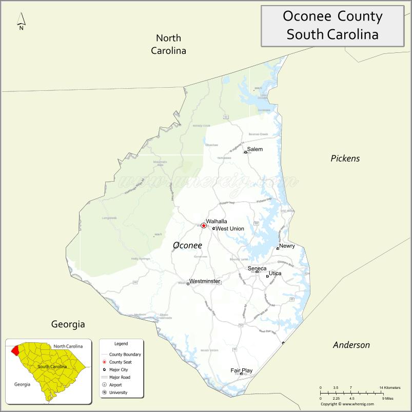
About Oconee County Map, South Carolina: The map showing the county boundary, county seat, major cities, highways, water bodies and neighbouring counties.
Related South Carolina Links
Map of Oconee County, South Carolina
Oconee County is a county located in the U.S. state of South Carolina. It's county seat is Walhalla. As per 2020 census, the population of Oconee County is 79203 people and population density is square miles. According to the United States Census Bureau, the county has a total area of 674 sq mi (1,746 km2). Oconee County was established on 1868.
Oconee County Facts
| Continent | North America |
| Country | United States |
| State | South Carolina |
| County Seat | Walhalla |
| Largest City/Town | Seneca |
| Established | 1868 |
| Total Area | 673.78 sq mi (1,744.07 sq km) |
| Land Area | 626.56 sq mi (1,622.78 sq km) |
| Water Area | 47.22 sq mi (122.29 sq km) |
| Population | 78,607 (Census 2020) |
| Population Density | 125.5 people per sq mi |
| Time Zone | Eastern (EST) |
| Major Highways | US-123, US-76, SC-11, SC-28 |
| Major Rivers | Chattooga River, Keowee River, Tugaloo River |
| Neighboring Counties | Pickens, Anderson, Rabun (GA), Stephens (GA), Macon (NC), Jackson (NC) |
| Famous For | Blue Ridge Mountains, waterfalls, outdoor recreation |
| Top Attractions | Lake Keowee, Lake Jocassee, Stumphouse Tunnel, Chattooga River |
| Official Website | Official Website |
About Oconee County, South Carolina
Oconee County is located in the northwestern corner of South Carolina in the United States and was established in 1868. The county seat is Walhalla, while the largest city is Seneca. The county lies in the Upstate region along the foothills of the Blue Ridge Mountains and is known for its scenic landscapes, lakes, waterfalls, and outdoor recreation opportunities.
Cities and Towns in Oconee County, South Carolina
| City/Town | Population (Census 2020) | Latitude & Longitude |
|---|---|---|
| Seneca | 8,850 | 34.6857N, 82.9532W |
| Walhalla (county seat) | 4,263 | 34.7648N, 83.0649W |
| West Union | 300+ | 34.7600N, 83.0500W |
| Salem | 150 | 34.8867N, 82.9700W |
| Westminster | 2,400+ | 34.6657N, 83.0979W |
| Fair Play (CDP) | ~N/A | 34.5040N, 82.9740W |
| Mountain Rest (CDP) | ~N/A | 34.8780N, 83.1160W |
Golf Courses in Oconee County, South Carolina
| Golf Course | Location | Latitude & Longitude |
|---|---|---|
| Cross Creek Plantation | Seneca | 34.7100N, 82.9800W |
| Oconee Country Club | Seneca | 34.6900N, 82.9500W |
| Chickasaw Point Golf Club | Westminster | 34.5300N, 83.0100W |
Roads and Highways in Oconee County, South Carolina
The county is connected by scenic highways and routes leading into the mountains.
- US-123 - major route connecting Oconee County to Greenville
- US-76 - runs through the county linking to Georgia and North Carolina
- SC-11 - scenic Cherokee Foothills Scenic Highway
- SC-28 - connects communities across the county
Neighboring Counties of Oconee County
- Pickens County (east)
- Anderson County (south)
- Rabun County, Georgia (southwest)
- Stephens County, Georgia (south)
- Macon County, North Carolina (north)
- Jackson County, North Carolina (north)
Top Attractions in Oconee County, South Carolina
The county is a major destination for outdoor enthusiasts.
- Lake Keowee - boating, fishing, and waterfront recreation
- Lake Jocassee - scenic mountain lake with waterfalls
- Stumphouse Tunnel - historic tunnel and nearby Issaqueena Falls
- Chattooga River - whitewater rafting and kayaking
- Sumter National Forest - hiking and camping
- Yellow Branch Falls - popular hiking destination
Distance from Oconee County to Nearby Cities
- Seneca to Greenville - 50 mi (80 km)
- Seneca to Atlanta - 110 mi (177 km)
- Seneca to Asheville - 80 mi (129 km)
- Seneca to Columbia - 130 mi (209 km)
- Seneca to Charlotte - 120 mi (193 km)
FAQs about Oconee County
Oconee County is located in the northwestern Upstate region of South Carolina along the Georgia and North Carolina borders.
The population of Oconee County is 78,607 according to the 2020 Census.
The county is known for its mountains, lakes, waterfalls, and outdoor recreation.
Major highways include US-123, US-76, SC-11, and SC-28.
Yes, Oconee County has several golf courses including Cross Creek Plantation and Chickasaw Point Golf Club.
- Abbeville County Map
- Aiken County Map
- Allendale County Map
- Anderson County Map
- Bamberg County Map
- Barnwell County Map
- Beaufort County Map
- Berkeley County Map
- Calhoun County Map
- Charleston County Map
- Cherokee County Map
- Chester County Map
- Chesterfield County Map
- Clarendon County Map
- Colleton County Map
- Darlington County Map
- Dillon County Map
- Dorchester County Map
- Edgefield County Map
- Fairfield County Map
- Florence County Map
- Georgetown County Map
- Greenville County Map
- Greenwood County Map
- Hampton County Map
- Horry County Map
- Jasper County Map
- Kershaw County Map
- Lancaster County Map
- Laurens County Map
- Lee County Map
- Lexington County Map
- McCormick County Map
- Marion County Map
- Marlboro County Map
- Newberry County Map
- Oconee County Map
- Orangeburg County Map
- Pickens County Map
- Richland County Map
- Saluda County Map
- Spartanburg County Map
- Sumter County Map
- Union County Map
- Williamsburg County Map
- York County Map
- Alabama Counties
- Alaska boroughs
- Arizona Counties
- Arkansas Counties
- California County Map
- Colorado Counties
- Connecticut Counties
- Delaware Counties
- Florida County Map
- Georgia County Map
- Hawaii Counties
- Idaho Counties
- Illinois Counties
- Indiana Counties
- Iowa Counties
- Kansas Counties
- Kentucky Counties
- Louisiana Counties
- Maine Counties
- Maryland Counties
- Massachusetts Counties
- Michigan County Map
- Minnesota Counties
- Mississippi Counties
- Missouri Counties
- Montana Counties
- Nebraska Counties
- Nevada Counties
- New York Counties
- New Hampshire Counties
- New Jersey Counties
- New Mexico Counties
- North Carolina Counties
- North Dakota Counties
- Ohio County Map
- Oklahoma Counties
- Oregon Counties
- Pennsylvania Counties
- Rhode Island Counties
- South Carolina Counties
- South Dakota Counties
- Map of Tennessee
- Texas County Map
- Utah Counties
- Vermont Counties
- Virginia Counties
- Washington Counties
- West Virginia Counties
- Wisconsin Counties
- Wyoming Counties