Written and Fact-checked by Whereig Editors | Updated On: May 05, 2026 | 14:50 ET
Map of Darlington County - Darlington County is a county located in the U.S. state of South Carolina. Darlington County Map showing cities, highways, important places and water bodies. Get Where is Darlington County located in the map, major cities in Darlington county, population, areas, and places of interest.
Map of Darlington County, South Carolina
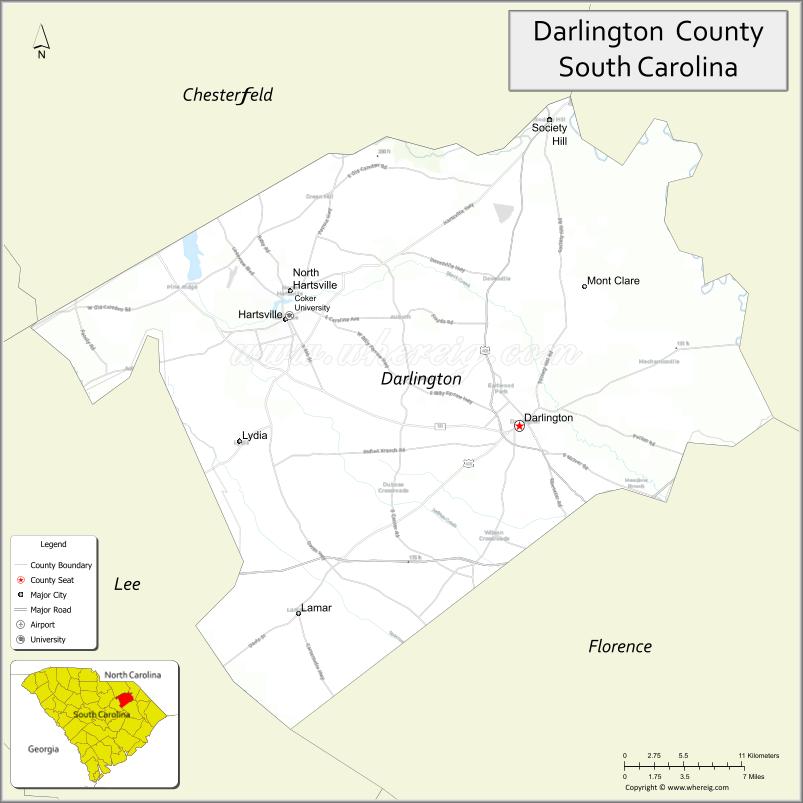
About Darlington County Map, South Carolina: The map showing the county boundary, county seat, major cities, highways, water bodies and neighbouring counties.
Related South Carolina Links
Map of Darlington County, South Carolina
Darlington County is a county located in the U.S. state of South Carolina. It's county seat is Darlington. As per 2020 census, the population of Darlington County is 62755 people and population density is square miles. According to the United States Census Bureau, the county has a total area of 567 sq mi (1,469 km2). Darlington County was established on 1785.
Darlington County Facts
| Continent | North America |
| Country | United States |
| State | South Carolina |
| County Seat | Darlington |
| Largest City/Town | Hartsville |
| Established | 1785 |
| Total Area | 561.13 sq mi (1,453.32 sq km) |
| Land Area | 560.01 sq mi (1,450.42 sq km) |
| Water Area | 1.12 sq mi (2.90 sq km) |
| Population | 65,737 (Census 2020) |
| Population Density | 117.4 people per sq mi |
| Time Zone | Eastern (EST) |
| Major Highways | I-20, I-95, US-52, US-15, SC-34, SC-151 |
| Major Rivers | Great Pee Dee River, Black Creek |
| Neighboring Counties | Florence, Marlboro, Chesterfield, Kershaw, Lee |
| Famous For | Darlington Raceway, motorsports, manufacturing |
| Top Attractions | Darlington Raceway, Coker College, Kalmia Gardens, Pearl Fryar Topiary Garden |
| Official Website | Official Website |
About Darlington County, South Carolina
Darlington County is located in the northeastern part of South Carolina in the United States and was established in 1785. The county seat is Darlington, while the largest city is Hartsville. The county lies in the Pee Dee region and is known for its strong industrial base, motorsports heritage, and scenic river systems.
Cities and Towns in Darlington County, South Carolina
| City/Town | Population (Census 2020) | Latitude & Longitude |
|---|---|---|
| Darlington (county seat) | 6,149 | 34.2999N, 79.8762W |
| Hartsville | 7,764 | 34.3732N, 80.0737W |
| Lamar | 1,037 | 34.2007N, 80.0623W |
| Society Hill | 600 | 34.5135N, 79.8525W |
| Timmonsville (partly) | 2,339 | 34.1346N, 79.9406W |
| North Hartsville (CDP) | 3,200+ | 34.3930N, 80.0700W |
| Darlington Raceway Area (CDP) | ~N/A | 34.2950N, 79.9050W |
Golf Courses in Darlington County, South Carolina
| Golf Course | Location | Latitude & Longitude |
|---|---|---|
| Hartsville Country Club | Hartsville | 34.3722N, 80.0835W |
| Greenwood Country Club | Darlington | 34.3050N, 79.8852W |
Roads and Highways in Darlington County, South Carolina
The county is well connected by major interstates and highways supporting regional travel.
- I-20 - connects the county to Columbia and Florence
- I-95 - major north-south interstate near the eastern edge
- US-52 - runs through Darlington and connects to Florence
- US-15 - links Hartsville to surrounding counties
- SC-34 - east-west route connecting to Camden and Bishopville
- SC-151 - connects Hartsville to McBee and nearby areas
Neighboring Counties of Darlington County
- Florence County (east)
- Marlboro County (north)
- Chesterfield County (northwest)
- Kershaw County (west)
- Lee County (south)
Top Attractions in Darlington County, South Carolina
The county offers a mix of motorsports, history, and natural beauty.
- Darlington Raceway - famous NASCAR track known as "The Track Too Tough to Tame"
- Kalmia Gardens - botanical garden and nature trails in Hartsville
- Pearl Fryar Topiary Garden - unique artistic garden display
- Coker University - historic campus in Hartsville
- Black Creek - scenic waterway for outdoor activities
- Society Hill Historic District - preserved historic town charm
Distance from Darlington County to Nearby Cities
- Darlington to Florence - 15 mi (24 km)
- Darlington to Columbia - 80 mi (129 km)
- Darlington to Charlotte - 100 mi (161 km)
- Darlington to Myrtle Beach - 80 mi (129 km)
- Darlington to Charleston - 140 mi (225 km)
FAQs about Darlington County
Darlington County is located in the northeastern Pee Dee region of South Carolina.
The population of Darlington County is 65,737 according to the 2020 Census.
The county is known for Darlington Raceway, motorsports, and manufacturing.
Major highways include I-20, I-95, US-52, US-15, SC-34, and SC-151.
Yes, Hartsville Country Club and Greenwood Country Club are located in the county.
- Abbeville County Map
- Aiken County Map
- Allendale County Map
- Anderson County Map
- Bamberg County Map
- Barnwell County Map
- Beaufort County Map
- Berkeley County Map
- Calhoun County Map
- Charleston County Map
- Cherokee County Map
- Chester County Map
- Chesterfield County Map
- Clarendon County Map
- Colleton County Map
- Darlington County Map
- Dillon County Map
- Dorchester County Map
- Edgefield County Map
- Fairfield County Map
- Florence County Map
- Georgetown County Map
- Greenville County Map
- Greenwood County Map
- Hampton County Map
- Horry County Map
- Jasper County Map
- Kershaw County Map
- Lancaster County Map
- Laurens County Map
- Lee County Map
- Lexington County Map
- McCormick County Map
- Marion County Map
- Marlboro County Map
- Newberry County Map
- Oconee County Map
- Orangeburg County Map
- Pickens County Map
- Richland County Map
- Saluda County Map
- Spartanburg County Map
- Sumter County Map
- Union County Map
- Williamsburg County Map
- York County Map
- Alabama Counties
- Alaska boroughs
- Arizona Counties
- Arkansas Counties
- California County Map
- Colorado Counties
- Connecticut Counties
- Delaware Counties
- Florida County Map
- Georgia County Map
- Hawaii Counties
- Idaho Counties
- Illinois Counties
- Indiana Counties
- Iowa Counties
- Kansas Counties
- Kentucky Counties
- Louisiana Counties
- Maine Counties
- Maryland Counties
- Massachusetts Counties
- Michigan County Map
- Minnesota Counties
- Mississippi Counties
- Missouri Counties
- Montana Counties
- Nebraska Counties
- Nevada Counties
- New York Counties
- New Hampshire Counties
- New Jersey Counties
- New Mexico Counties
- North Carolina Counties
- North Dakota Counties
- Ohio County Map
- Oklahoma Counties
- Oregon Counties
- Pennsylvania Counties
- Rhode Island Counties
- South Carolina Counties
- South Dakota Counties
- Map of Tennessee
- Texas County Map
- Utah Counties
- Vermont Counties
- Virginia Counties
- Washington Counties
- West Virginia Counties
- Wisconsin Counties
- Wyoming Counties