Written and Fact-checked by Whereig Editors | Updated On: May 05, 2026 | 14:50 ET
Map of Lee County - Lee County is a county located in the U.S. state of South Carolina. Lee County Map showing cities, highways, important places and water bodies. Get Where is Lee County located in the map, major cities in Lee county, population, areas, and places of interest.
Map of Lee County, South Carolina
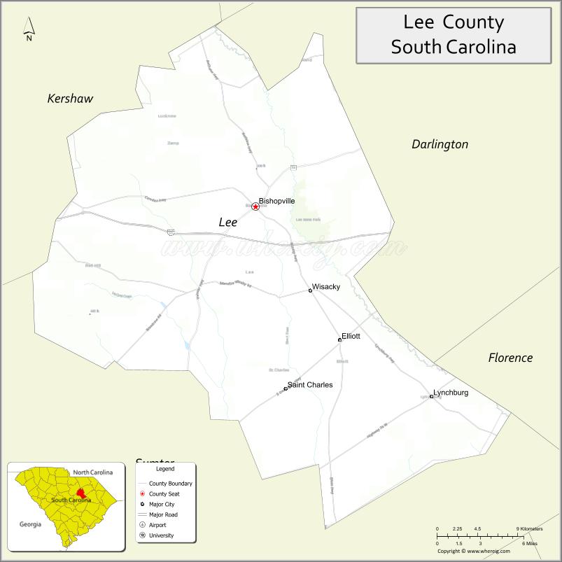
About Lee County Map, South Carolina: The map showing the county boundary, county seat, major cities, highways, water bodies and neighbouring counties.
Related South Carolina Links
Map of Lee County, South Carolina
Lee County is a county located in the U.S. state of South Carolina. It's county seat is Bishopville. As per 2020 census, the population of Lee County is 16280 people and population density is square miles. According to the United States Census Bureau, the county has a total area of 411 sq mi (1,064 km2). Lee County was established on 1902.
Lee County Facts
| Continent | North America |
| Country | United States |
| State | South Carolina |
| County Seat | Bishopville |
| Largest City/Town | Bishopville |
| Established | 1902 |
| Total Area | 411.23 sq mi (1,065.07 sq km) |
| Land Area | 410.72 sq mi (1,063.76 sq km) |
| Water Area | 0.51 sq mi (1.31 sq km) |
| Population | 16,531 (Census 2020) |
| Population Density | 40.2 people per sq mi |
| Time Zone | Eastern (EST) |
| Major Highways | I-20, US-15, US-401, SC-34, SC-341 |
| Major Rivers | Lynches River |
| Neighboring Counties | Kershaw, Darlington, Florence, Sumter |
| Famous For | Pearl Fryar Topiary Garden, rural heritage, Bishopville Lizard Man legend |
| Top Attractions | Pearl Fryar Topiary Garden, Lee State Park, Bishopville Historic District |
| Official Website | Official Website |
About Lee County, South Carolina
Lee County is located in the central-eastern part of South Carolina in the United States and was established in 1902. The county seat is Bishopville, which is also the largest city. The county lies in the Pee Dee and Midlands transition region and is known for its agricultural roots, small-town charm, and unique attractions such as the famous topiary garden.
Cities and Towns in Lee County, South Carolina
| City/Town | Population (Census 2020) | Latitude & Longitude |
|---|---|---|
| Bishopville (county seat) | 3,315 | 34.2188N, 80.2484W |
| Lynchburg (partly) | 400+ | 34.0604N, 80.0559W |
| Mayesville (partly) | 700+ | 34.0805N, 80.2081W |
| Manville (CDP) | ~N/A | 34.2000N, 80.2600W |
| Lucknow (CDP) | ~N/A | 34.2300N, 80.3000W |
Golf Courses in Lee County, South Carolina
| Golf Course | Location | Latitude & Longitude |
|---|---|---|
| Bishopville Country Club | Bishopville | 34.2180N, 80.2500W |
| Lynches River Golf Course (nearby) | Sumter area | 33.9500N, 80.3500W |
Roads and Highways in Lee County, South Carolina
The county is served by highways that connect it to major cities and surrounding regions.
- I-20 - major interstate connecting Bishopville to Columbia and Florence
- US-15 - north-south route linking the county to surrounding areas
- US-401 - runs through Bishopville connecting to nearby cities
- SC-34 - east-west route connecting to Darlington and Newberry
- SC-341 - provides local access across the county
Neighboring Counties of Lee County
- Kershaw County (north)
- Darlington County (northeast)
- Florence County (east)
- Sumter County (south and west)
Top Attractions in Lee County, South Carolina
The county offers unique attractions and natural scenery.
- Pearl Fryar Topiary Garden - nationally recognized topiary art garden
- Lee State Park - camping, hiking, and horseback riding
- Bishopville Historic District - historic buildings and local culture
- Lynches River - kayaking, fishing, and scenic views
- Button Museum - collection of antique buttons
- Scape Ore Swamp - natural wetlands and wildlife habitat
Distance from Lee County to Nearby Cities
- Bishopville to Columbia - 45 mi (72 km)
- Bishopville to Florence - 35 mi (56 km)
- Bishopville to Charleston - 120 mi (193 km)
- Bishopville to Charlotte - 90 mi (145 km)
- Bishopville to Greenville - 110 mi (177 km)
FAQs about Lee County
Lee County is located in the central-eastern region of South Carolina.
The population of Lee County is 16,531 according to the 2020 Census.
The county is known for the Pearl Fryar Topiary Garden and the local Lizard Man legend.
Major highways include I-20, US-15, US-401, SC-34, and SC-341.
Yes, Bishopville Country Club is a known golf course in the county.
- Abbeville County Map
- Aiken County Map
- Allendale County Map
- Anderson County Map
- Bamberg County Map
- Barnwell County Map
- Beaufort County Map
- Berkeley County Map
- Calhoun County Map
- Charleston County Map
- Cherokee County Map
- Chester County Map
- Chesterfield County Map
- Clarendon County Map
- Colleton County Map
- Darlington County Map
- Dillon County Map
- Dorchester County Map
- Edgefield County Map
- Fairfield County Map
- Florence County Map
- Georgetown County Map
- Greenville County Map
- Greenwood County Map
- Hampton County Map
- Horry County Map
- Jasper County Map
- Kershaw County Map
- Lancaster County Map
- Laurens County Map
- Lee County Map
- Lexington County Map
- McCormick County Map
- Marion County Map
- Marlboro County Map
- Newberry County Map
- Oconee County Map
- Orangeburg County Map
- Pickens County Map
- Richland County Map
- Saluda County Map
- Spartanburg County Map
- Sumter County Map
- Union County Map
- Williamsburg County Map
- York County Map
- Alabama Counties
- Alaska boroughs
- Arizona Counties
- Arkansas Counties
- California County Map
- Colorado Counties
- Connecticut Counties
- Delaware Counties
- Florida County Map
- Georgia County Map
- Hawaii Counties
- Idaho Counties
- Illinois Counties
- Indiana Counties
- Iowa Counties
- Kansas Counties
- Kentucky Counties
- Louisiana Counties
- Maine Counties
- Maryland Counties
- Massachusetts Counties
- Michigan County Map
- Minnesota Counties
- Mississippi Counties
- Missouri Counties
- Montana Counties
- Nebraska Counties
- Nevada Counties
- New York Counties
- New Hampshire Counties
- New Jersey Counties
- New Mexico Counties
- North Carolina Counties
- North Dakota Counties
- Ohio County Map
- Oklahoma Counties
- Oregon Counties
- Pennsylvania Counties
- Rhode Island Counties
- South Carolina Counties
- South Dakota Counties
- Map of Tennessee
- Texas County Map
- Utah Counties
- Vermont Counties
- Virginia Counties
- Washington Counties
- West Virginia Counties
- Wisconsin Counties
- Wyoming Counties