Written and Fact-checked by Whereig Editors | Updated On: May 05, 2026 | 14:50 ET
Map of Union County - Union County is a county located in the U.S. state of South Carolina. Union County Map showing cities, highways, important places and water bodies. Get Where is Union County located in the map, major cities in Union county, population, areas, and places of interest.
Map of Union County, South Carolina
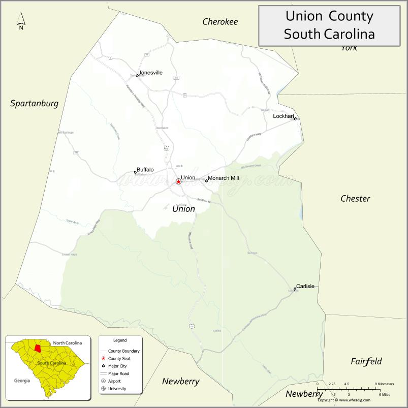
About Union County Map, South Carolina: The map showing the county boundary, county seat, major cities, highways, water bodies and neighbouring counties.
Related South Carolina Links
Map of Union County, South Carolina
Union County is a county located in the U.S. state of South Carolina. It's county seat is Union. As per 2020 census, the population of Union County is 27016 people and population density is square miles. According to the United States Census Bureau, the county has a total area of 516 sq mi (1,336 km2). Union County was established on 1798.
Union County Facts
| Continent | North America |
| Country | United States |
| State | South Carolina |
| County Seat | Union |
| Largest City/Town | Union |
| Established | 1785 |
| Total Area | 514.20 sq mi (1,331.77 sq km) |
| Land Area | 514.00 sq mi (1,331.26 sq km) |
| Water Area | 0.20 sq mi (0.51 sq km) |
| Population | 26,358 (Census 2020) |
| Population Density | 51.3 people per sq mi |
| Time Zone | Eastern (EST) |
| Major Highways | US-176, US-221, SC-9, SC-49 |
| Major Rivers | Broad River, Tyger River |
| Neighboring Counties | Spartanburg, Cherokee, York, Chester, Fairfield, Newberry, Laurens |
| Famous For | Historic downtown Union, Revolutionary War sites, rural landscapes |
| Top Attractions | Rose Hill Plantation State Historic Site, Sumter National Forest, Union County Museum |
| Official Website | Official Website |
About Union County, South Carolina
Union County is located in the northwestern part of South Carolina in the United States and was established in 1785. The county seat and largest city is Union. The county lies in the Upstate region and is known for its historical significance, especially during the Revolutionary War, as well as its rural landscapes and preserved historic sites.
Cities and Towns in Union County, South Carolina
| City/Town | Population (Census 2020) | Latitude & Longitude |
|---|---|---|
| Union (county seat) | 7,652 | 34.7154N, 81.6234W |
| Jonesville | 900+ | 34.8354N, 81.6809W |
| Lockhart | 400+ | 34.7904N, 81.4412W |
| Carlisle | 300+ | 34.6000N, 81.5000W |
| Buffalo (CDP) | 1,200+ | 34.7200N, 81.6800W |
| Monarch Mill (CDP) | 2,000+ | 34.7300N, 81.6200W |
Golf Courses in Union County, South Carolina
| Golf Course | Location | Latitude & Longitude |
|---|---|---|
| Rose Hill Plantation Golf Course | Union | 34.7100N, 81.6200W |
| Union Country Club | Union | 34.7200N, 81.6300W |
Roads and Highways in Union County, South Carolina
The county is connected by highways that provide access to surrounding Upstate regions.
- US-176 - runs through Union connecting to Spartanburg and Chester
- US-221 - links Union to Laurens and Cherokee counties
- SC-9 - connects to York and Chester counties
- SC-49 - provides regional access across the county
Neighboring Counties of Union County
- Spartanburg County (northwest)
- Cherokee County (north)
- York County (northeast)
- Chester County (east)
- Fairfield County (southeast)
- Newberry County (south)
- Laurens County (west)
Top Attractions in Union County, South Carolina
The county offers historical landmarks and outdoor recreation.
- Rose Hill Plantation State Historic Site - historic plantation and grounds
- Sumter National Forest - hiking, camping, and outdoor activities
- Union County Museum - local history exhibits
- Broad River - fishing and outdoor recreation
- Tyger River - scenic views and kayaking
- Downtown Union - historic architecture and local shops
Distance from Union County to Nearby Cities
- Union to Spartanburg - 30 mi (48 km)
- Union to Greenville - 60 mi (97 km)
- Union to Charlotte - 70 mi (113 km)
- Union to Columbia - 80 mi (129 km)
- Union to Atlanta - 170 mi (274 km)
FAQs about Union County
Union County is located in the northwestern Upstate region of South Carolina.
The population of Union County is 26,358 according to the 2020 Census.
The county is known for its Revolutionary War history, rural landscapes, and historic sites.
Major highways include US-176, US-221, SC-9, and SC-49.
Yes, Rose Hill Plantation Golf Course and Union Country Club are located in the county.
- Abbeville County Map
- Aiken County Map
- Allendale County Map
- Anderson County Map
- Bamberg County Map
- Barnwell County Map
- Beaufort County Map
- Berkeley County Map
- Calhoun County Map
- Charleston County Map
- Cherokee County Map
- Chester County Map
- Chesterfield County Map
- Clarendon County Map
- Colleton County Map
- Darlington County Map
- Dillon County Map
- Dorchester County Map
- Edgefield County Map
- Fairfield County Map
- Florence County Map
- Georgetown County Map
- Greenville County Map
- Greenwood County Map
- Hampton County Map
- Horry County Map
- Jasper County Map
- Kershaw County Map
- Lancaster County Map
- Laurens County Map
- Lee County Map
- Lexington County Map
- McCormick County Map
- Marion County Map
- Marlboro County Map
- Newberry County Map
- Oconee County Map
- Orangeburg County Map
- Pickens County Map
- Richland County Map
- Saluda County Map
- Spartanburg County Map
- Sumter County Map
- Union County Map
- Williamsburg County Map
- York County Map
- Alabama Counties
- Alaska boroughs
- Arizona Counties
- Arkansas Counties
- California County Map
- Colorado Counties
- Connecticut Counties
- Delaware Counties
- Florida County Map
- Georgia County Map
- Hawaii Counties
- Idaho Counties
- Illinois Counties
- Indiana Counties
- Iowa Counties
- Kansas Counties
- Kentucky Counties
- Louisiana Counties
- Maine Counties
- Maryland Counties
- Massachusetts Counties
- Michigan County Map
- Minnesota Counties
- Mississippi Counties
- Missouri Counties
- Montana Counties
- Nebraska Counties
- Nevada Counties
- New York Counties
- New Hampshire Counties
- New Jersey Counties
- New Mexico Counties
- North Carolina Counties
- North Dakota Counties
- Ohio County Map
- Oklahoma Counties
- Oregon Counties
- Pennsylvania Counties
- Rhode Island Counties
- South Carolina Counties
- South Dakota Counties
- Map of Tennessee
- Texas County Map
- Utah Counties
- Vermont Counties
- Virginia Counties
- Washington Counties
- West Virginia Counties
- Wisconsin Counties
- Wyoming Counties