Written and Fact-checked by Whereig Editors | Updated On: May 05, 2026 | 14:50 ET
Map of Clarendon County - Clarendon County is a county located in the U.S. state of South Carolina. Clarendon County Map showing cities, highways, important places and water bodies. Get Where is Clarendon County located in the map, major cities in Clarendon county, population, areas, and places of interest.
Map of Clarendon County, South Carolina
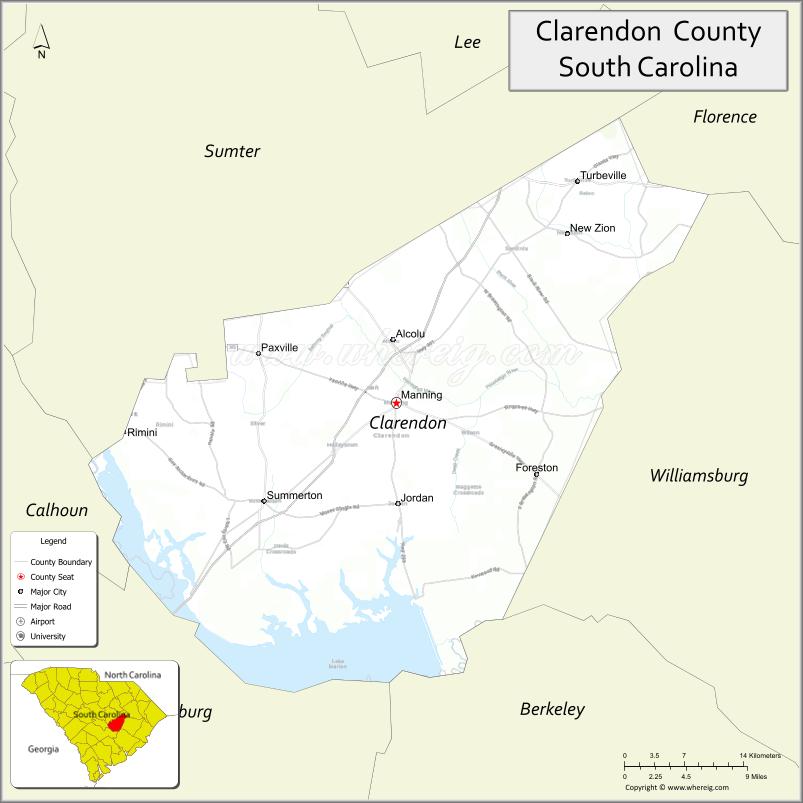
About Clarendon County Map, South Carolina: The map showing the county boundary, county seat, major cities, highways, water bodies and neighbouring counties.
Related South Carolina Links
Map of Clarendon County, South Carolina
Clarendon County is a county located in the U.S. state of South Carolina. It's county seat is Manning. As per 2020 census, the population of Clarendon County is 31024 people and population density is square miles. According to the United States Census Bureau, the county has a total area of 696 sq mi (1,803 km2). Clarendon County was established on 1855.
Clarendon County Facts
| Continent | North America |
| Country | United States |
| State | South Carolina |
| County Seat | Manning |
| Largest City/Town | Manning |
| Established | 1785 |
| Total Area | 695.18 sq mi (1,800.53 sq km) |
| Land Area | 606.71 sq mi (1,571.38 sq km) |
| Water Area | 88.47 sq mi (229.15 sq km) |
| Population | 31,144 (Census 2020) |
| Population Density | 51.3 people per sq mi |
| Time Zone | Eastern (EST) |
| Major Highways | I-95, US-301, US-521, SC-260, SC-261 |
| Major Rivers | Santee River, Black River |
| Neighboring Counties | Sumter, Lee, Florence, Williamsburg, Berkeley, Orangeburg |
| Famous For | Lake Marion, fishing, outdoor recreation |
| Top Attractions | Lake Marion, Santee National Wildlife Refuge, Manning Historic District |
| Official Website | Official Website |
About Clarendon County, South Carolina
Clarendon County is located in the east-central part of South Carolina in the United States and was established in 1785. The county seat is Manning, which is also the largest town. The county lies in the Midlands and Pee Dee regions and is known for its large lakes, especially Lake Marion, along with its importance for fishing, boating, and wildlife habitats.
Cities and Towns in Clarendon County, South Carolina
| City/Town | Population (Census 2020) | Latitude & Longitude |
|---|---|---|
| Manning (county seat) | 4,053 | 33.6957N, 80.2106W |
| Summerton | 814 | 33.5985N, 80.3520W |
| Turbeville (partly) | 819 | 33.8890N, 80.0106W |
| Paxville | 148 | 33.7368N, 80.1609W |
| Alcolu (CDP) | 429 | 33.7893N, 80.1520W |
| Gable (CDP) | 300+ | 33.8257N, 80.1326W |
| Silver (CDP) | ~N/A | 33.7150N, 80.4200W |
Golf Courses in Clarendon County, South Carolina
| Golf Course | Location | Latitude & Longitude |
|---|---|---|
| Wyboo Golf Club | Manning | 33.6015N, 80.2954W |
| Players Course at Wyboo | Manning | 33.6008N, 80.3002W |
| Foxboro Golf Club | Manning | 33.7012N, 80.2185W |
Roads and Highways in Clarendon County, South Carolina
The county is served by major highways that support regional travel and tourism.
- I-95 - major north-south interstate running through the county
- US-301 - parallels I-95 and connects local communities
- US-521 - links Manning to Sumter and Georgetown
- SC-260 - connects Summerton and Manning
- SC-261 - serves local areas within the county
Neighboring Counties of Clarendon County
- Sumter County (north)
- Lee County (northwest)
- Florence County (northeast)
- Williamsburg County (east)
- Berkeley County (south)
- Orangeburg County (southwest)
Top Attractions in Clarendon County, South Carolina
The county is known for outdoor recreation and natural beauty.
- Lake Marion - one of the largest lakes in South Carolina for fishing and boating
- Santee National Wildlife Refuge - birdwatching and wildlife habitat
- Manning Historic District - historic buildings and local charm
- Wyboo Creek - popular area for water recreation
- Potato Creek - scenic waterways and fishing spots
- Summerton Lakefront - access to lake activities and views
Distance from Clarendon County to Nearby Cities
- Manning to Sumter - 25 mi (40 km)
- Manning to Columbia - 70 mi (113 km)
- Manning to Charleston - 90 mi (145 km)
- Manning to Florence - 45 mi (72 km)
- Manning to Myrtle Beach - 90 mi (145 km)
FAQs about Clarendon County
Clarendon County is located in the east-central region of South Carolina.
The population of Clarendon County is 31,144 according to the 2020 Census.
The county is known for Lake Marion, fishing, and outdoor recreation.
Major highways include I-95, US-301, US-521, SC-260, and SC-261.
Yes, golf courses such as Wyboo Golf Club and Foxboro Golf Club are located in the county.
- Abbeville County Map
- Aiken County Map
- Allendale County Map
- Anderson County Map
- Bamberg County Map
- Barnwell County Map
- Beaufort County Map
- Berkeley County Map
- Calhoun County Map
- Charleston County Map
- Cherokee County Map
- Chester County Map
- Chesterfield County Map
- Clarendon County Map
- Colleton County Map
- Darlington County Map
- Dillon County Map
- Dorchester County Map
- Edgefield County Map
- Fairfield County Map
- Florence County Map
- Georgetown County Map
- Greenville County Map
- Greenwood County Map
- Hampton County Map
- Horry County Map
- Jasper County Map
- Kershaw County Map
- Lancaster County Map
- Laurens County Map
- Lee County Map
- Lexington County Map
- McCormick County Map
- Marion County Map
- Marlboro County Map
- Newberry County Map
- Oconee County Map
- Orangeburg County Map
- Pickens County Map
- Richland County Map
- Saluda County Map
- Spartanburg County Map
- Sumter County Map
- Union County Map
- Williamsburg County Map
- York County Map
- Alabama Counties
- Alaska boroughs
- Arizona Counties
- Arkansas Counties
- California County Map
- Colorado Counties
- Connecticut Counties
- Delaware Counties
- Florida County Map
- Georgia County Map
- Hawaii Counties
- Idaho Counties
- Illinois Counties
- Indiana Counties
- Iowa Counties
- Kansas Counties
- Kentucky Counties
- Louisiana Counties
- Maine Counties
- Maryland Counties
- Massachusetts Counties
- Michigan County Map
- Minnesota Counties
- Mississippi Counties
- Missouri Counties
- Montana Counties
- Nebraska Counties
- Nevada Counties
- New York Counties
- New Hampshire Counties
- New Jersey Counties
- New Mexico Counties
- North Carolina Counties
- North Dakota Counties
- Ohio County Map
- Oklahoma Counties
- Oregon Counties
- Pennsylvania Counties
- Rhode Island Counties
- South Carolina Counties
- South Dakota Counties
- Map of Tennessee
- Texas County Map
- Utah Counties
- Vermont Counties
- Virginia Counties
- Washington Counties
- West Virginia Counties
- Wisconsin Counties
- Wyoming Counties