Written and Fact-checked by Whereig Editors | Updated On: May 05, 2026 | 14:50 ET
Map of Allendale County - Allendale County is a county located in the U.S. state of South Carolina. Allendale County Map showing cities, highways, important places and water bodies. Get Where is Allendale County located in the map, major cities in Allendale county, population, areas, and places of interest.
Map of Allendale County, South Carolina
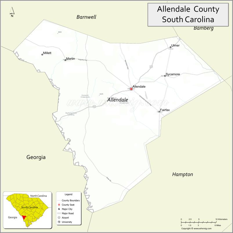
About Allendale County Map, South Carolina: The map showing the county boundary, county seat, major cities, highways, water bodies and neighbouring counties.
Related South Carolina Links
Map of Allendale County, South Carolina
Allendale County is a county located in the U.S. state of South Carolina. It's county seat is Allendale. As per 2020 census, the population of Allendale County is 7858 people and population density is square miles. According to the United States Census Bureau, the county has a total area of 413 sq mi (1,070 km2). Allendale County was established on 1919.
Allendale County Facts
| Continent | North America |
| Country | United States |
| State | South Carolina |
| County Seat | Allendale |
| Largest City/Town | Allendale |
| Established | 1919 |
| Total Area | 412.21 sq mi (1,067.62 sq km) |
| Land Area | 407.42 sq mi (1,055.22 sq km) |
| Water Area | 4.79 sq mi (12.40 sq km) |
| Population | 8,039 (Census 2020) |
| Population Density | 19.7 people per sq mi |
| Time Zone | Eastern (EST) |
| Major Highways | US-278, SC-3, SC-64, SC-125 |
| Major Rivers | Savannah River, Salkehatchie River |
| Neighboring Counties | Barnwell, Hampton, Colleton, Bamberg, Screven (GA) |
| Famous For | Rural landscapes, agriculture, proximity to Savannah River |
| Top Attractions | Savannah River access, Rivers Bridge State Historic Site (nearby), local parks |
| Official Website | Official Website |
About Allendale County, South Carolina
Allendale County is located in the southern part of South Carolina in the United States and was established in 1919. The county seat is Allendale, which is also the largest town. The county features flat coastal plain terrain, agricultural land, and access to the Savannah River, making it an important rural and farming region.
Cities and Towns in Allendale County, South Carolina
| City/Town | Population (Census 2020) | Latitude & Longitude |
|---|---|---|
| Allendale (county seat) | 2,694 | 33.0079N, 81.3084W |
| Fairfax | 1,750 | 32.9585N, 81.2387W |
| Sycamore | 168 | 33.0402N, 81.2259W |
| Ulmer | 65 | 33.0968N, 81.2128W |
| Barton (CDP) | ~N/A | 33.0200N, 81.3200W |
Golf Courses in Allendale County, South Carolina
| Golf Course | Location | Latitude & Longitude |
|---|---|---|
| None widely documented | � | � |
Roads and Highways in Allendale County, South Carolina
The county is connected by a small network of highways serving rural communities.
- US-278 - main east-west route connecting Barnwell and Hampton counties
- SC-3 - runs north-south through Allendale and Fairfax
- SC-64 - connects Allendale to Barnwell and Hampton
- SC-125 - links smaller communities within the county
Neighboring Counties of Allendale County
- Bamberg County (north)
- Barnwell County (northwest)
- Hampton County (south)
- Colleton County (east)
- Screven County, Georgia (west)
Top Attractions in Allendale County, South Carolina
The county offers quiet rural charm and nearby historic and natural sites.
- Savannah River - scenic views and fishing opportunities
- Allendale County Recreation Park - local outdoor activities
- Fairfax Historic District - small-town historic charm
- Rivers Bridge State Historic Site (nearby) - Civil War battlefield site
- Local farmland landscapes - peaceful countryside scenery
- Salkehatchie River - opportunities for kayaking and nature viewing
Distance from Allendale County to Nearby Cities
- Allendale to Barnwell - 15 mi (24 km)
- Allendale to Hampton - 30 mi (48 km)
- Allendale to Aiken - 70 mi (113 km)
- Allendale to Augusta - 75 mi (121 km)
- Allendale to Columbia - 90 mi (145 km)
FAQs about Allendale County
Allendale County is located in southern South Carolina near the Georgia border.
The population of Allendale County is 8,039 according to the 2020 Census.
The county is known for its rural landscapes, agriculture, and proximity to the Savannah River.
Major highways include US-278, SC-3, SC-64, and SC-125.
There are no widely documented major golf courses in Allendale County.
- Abbeville County Map
- Aiken County Map
- Allendale County Map
- Anderson County Map
- Bamberg County Map
- Barnwell County Map
- Beaufort County Map
- Berkeley County Map
- Calhoun County Map
- Charleston County Map
- Cherokee County Map
- Chester County Map
- Chesterfield County Map
- Clarendon County Map
- Colleton County Map
- Darlington County Map
- Dillon County Map
- Dorchester County Map
- Edgefield County Map
- Fairfield County Map
- Florence County Map
- Georgetown County Map
- Greenville County Map
- Greenwood County Map
- Hampton County Map
- Horry County Map
- Jasper County Map
- Kershaw County Map
- Lancaster County Map
- Laurens County Map
- Lee County Map
- Lexington County Map
- McCormick County Map
- Marion County Map
- Marlboro County Map
- Newberry County Map
- Oconee County Map
- Orangeburg County Map
- Pickens County Map
- Richland County Map
- Saluda County Map
- Spartanburg County Map
- Sumter County Map
- Union County Map
- Williamsburg County Map
- York County Map
- Alabama Counties
- Alaska boroughs
- Arizona Counties
- Arkansas Counties
- California County Map
- Colorado Counties
- Connecticut Counties
- Delaware Counties
- Florida County Map
- Georgia County Map
- Hawaii Counties
- Idaho Counties
- Illinois Counties
- Indiana Counties
- Iowa Counties
- Kansas Counties
- Kentucky Counties
- Louisiana Counties
- Maine Counties
- Maryland Counties
- Massachusetts Counties
- Michigan County Map
- Minnesota Counties
- Mississippi Counties
- Missouri Counties
- Montana Counties
- Nebraska Counties
- Nevada Counties
- New York Counties
- New Hampshire Counties
- New Jersey Counties
- New Mexico Counties
- North Carolina Counties
- North Dakota Counties
- Ohio County Map
- Oklahoma Counties
- Oregon Counties
- Pennsylvania Counties
- Rhode Island Counties
- South Carolina Counties
- South Dakota Counties
- Map of Tennessee
- Texas County Map
- Utah Counties
- Vermont Counties
- Virginia Counties
- Washington Counties
- West Virginia Counties
- Wisconsin Counties
- Wyoming Counties