Written and Fact-checked by Whereig Editors | Updated On: May 05, 2026 | 14:50 ET
Map of Saluda County - Saluda County is a county located in the U.S. state of South Carolina. Saluda County Map showing cities, highways, important places and water bodies. Get Where is Saluda County located in the map, major cities in Saluda county, population, areas, and places of interest.
Map of Saluda County, South Carolina
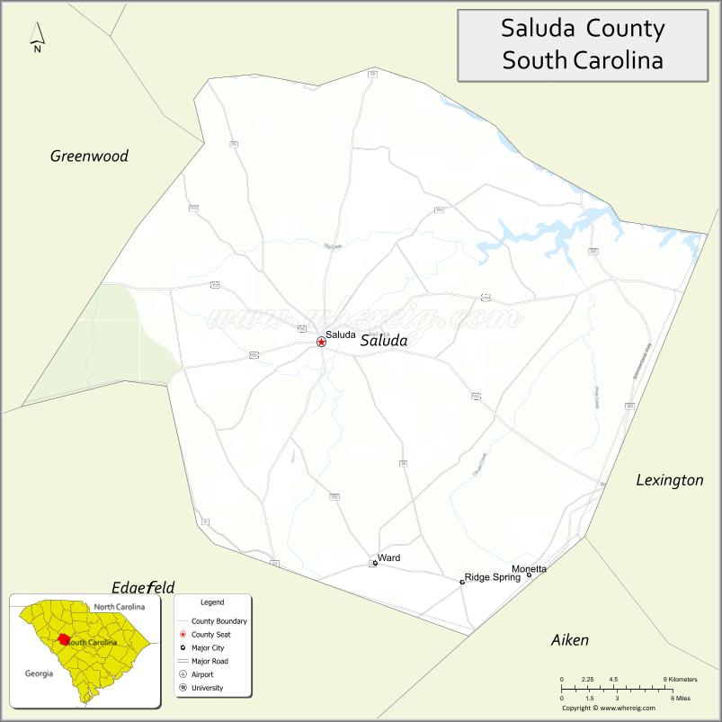
About Saluda County Map, South Carolina: The map showing the county boundary, county seat, major cities, highways, water bodies and neighbouring counties.
Related South Carolina Links
Map of Saluda County, South Carolina
Saluda County is a county located in the U.S. state of South Carolina. It's county seat is Saluda. As per 2020 census, the population of Saluda County is 18821 people and population density is square miles. According to the United States Census Bureau, the county has a total area of 462 sq mi (1,197 km2). Saluda County was established on 1896.
Saluda County Facts
| Continent | North America |
| Country | United States |
| State | South Carolina |
| County Seat | Saluda |
| Largest City/Town | Saluda |
| Established | 1895 |
| Total Area | 462.35 sq mi (1,197.48 sq km) |
| Land Area | 451.02 sq mi (1,168.15 sq km) |
| Water Area | 11.33 sq mi (29.33 sq km) |
| Population | 19,875 (Census 2020) |
| Population Density | 44.1 people per sq mi |
| Time Zone | Eastern (EST) |
| Major Highways | US-178, US-378, SC-39, SC-121 |
| Major Rivers | Saluda River, Little Saluda River |
| Neighboring Counties | Newberry, Lexington, Aiken, Edgefield, Greenwood |
| Famous For | Lake Murray access, rural landscapes, agriculture |
| Top Attractions | Lake Murray (nearby), Saluda County Museum, Little River Blueway |
| Official Website | Official Website |
About Saluda County, South Carolina
Saluda County is located in the western Midlands region of South Carolina in the United States and was established in 1895. The county seat and largest town is Saluda. The county lies along the Saluda River and is known for its rural charm, agricultural economy, and access to Lake Murray and surrounding natural areas.
Cities and Towns in Saluda County, South Carolina
| City/Town | Population (Census 2020) | Latitude & Longitude |
|---|---|---|
| Saluda (county seat) | 3,565 | 34.0018N, 81.7732W |
| Ridge Spring (partly) | 700+ | 33.8450N, 81.6600W |
| Ward (partly) | 100+ | 33.8850N, 81.7200W |
| Hollywood (CDP) | ~N/A | 34.0200N, 81.8000W |
| Fruit Hill (CDP) | ~N/A | 34.0500N, 81.7500W |
Golf Courses in Saluda County, South Carolina
| Golf Course | Location | Latitude & Longitude |
|---|---|---|
| Persimmon Hill Golf Club | Saluda | 34.0100N, 81.7800W |
| Lake Murray Golf Center (nearby) | Lexington area | 33.9800N, 81.2000W |
Roads and Highways in Saluda County, South Carolina
The county is served by highways connecting it to nearby counties and regions.
- US-178 - runs through Saluda connecting to Greenwood and Lexington
- US-378 - connects Saluda to Columbia and Augusta
- SC-39 - links rural communities across the county
- SC-121 - connects Saluda to Newberry and Edgefield
Neighboring Counties of Saluda County
- Newberry County (north)
- Lexington County (east)
- Aiken County (south)
- Edgefield County (west)
- Greenwood County (northwest)
Top Attractions in Saluda County, South Carolina
The county offers quiet outdoor recreation and local history.
- Lake Murray (nearby) - boating, fishing, and recreation
- Saluda County Museum - local history and exhibits
- Little River Blueway - kayaking and scenic waterways
- Saluda River - fishing and outdoor activities
- Downtown Saluda - small-town charm and local shops
- Local farms - agriculture and seasonal produce
Distance from Saluda County to Nearby Cities
- Saluda to Columbia - 50 mi (80 km)
- Saluda to Augusta - 60 mi (97 km)
- Saluda to Greenville - 80 mi (129 km)
- Saluda to Charlotte - 110 mi (177 km)
- Saluda to Charleston - 130 mi (209 km)
FAQs about Saluda County
Saluda County is located in the western Midlands region of South Carolina.
The population of Saluda County is 19,875 according to the 2020 Census.
The county is known for its rural landscapes, agriculture, and proximity to Lake Murray.
Major highways include US-178, US-378, SC-39, and SC-121.
Yes, Persimmon Hill Golf Club is a known golf course in the county.
- Abbeville County Map
- Aiken County Map
- Allendale County Map
- Anderson County Map
- Bamberg County Map
- Barnwell County Map
- Beaufort County Map
- Berkeley County Map
- Calhoun County Map
- Charleston County Map
- Cherokee County Map
- Chester County Map
- Chesterfield County Map
- Clarendon County Map
- Colleton County Map
- Darlington County Map
- Dillon County Map
- Dorchester County Map
- Edgefield County Map
- Fairfield County Map
- Florence County Map
- Georgetown County Map
- Greenville County Map
- Greenwood County Map
- Hampton County Map
- Horry County Map
- Jasper County Map
- Kershaw County Map
- Lancaster County Map
- Laurens County Map
- Lee County Map
- Lexington County Map
- McCormick County Map
- Marion County Map
- Marlboro County Map
- Newberry County Map
- Oconee County Map
- Orangeburg County Map
- Pickens County Map
- Richland County Map
- Saluda County Map
- Spartanburg County Map
- Sumter County Map
- Union County Map
- Williamsburg County Map
- York County Map
- Alabama Counties
- Alaska boroughs
- Arizona Counties
- Arkansas Counties
- California County Map
- Colorado Counties
- Connecticut Counties
- Delaware Counties
- Florida County Map
- Georgia County Map
- Hawaii Counties
- Idaho Counties
- Illinois Counties
- Indiana Counties
- Iowa Counties
- Kansas Counties
- Kentucky Counties
- Louisiana Counties
- Maine Counties
- Maryland Counties
- Massachusetts Counties
- Michigan County Map
- Minnesota Counties
- Mississippi Counties
- Missouri Counties
- Montana Counties
- Nebraska Counties
- Nevada Counties
- New York Counties
- New Hampshire Counties
- New Jersey Counties
- New Mexico Counties
- North Carolina Counties
- North Dakota Counties
- Ohio County Map
- Oklahoma Counties
- Oregon Counties
- Pennsylvania Counties
- Rhode Island Counties
- South Carolina Counties
- South Dakota Counties
- Map of Tennessee
- Texas County Map
- Utah Counties
- Vermont Counties
- Virginia Counties
- Washington Counties
- West Virginia Counties
- Wisconsin Counties
- Wyoming Counties