Written and Fact-checked by Whereig Editors | Updated On: May 05, 2026 | 14:50 ET
Map of Newberry County - Newberry County is a county located in the U.S. state of South Carolina. Newberry County Map showing cities, highways, important places and water bodies. Get Where is Newberry County located in the map, major cities in Newberry county, population, areas, and places of interest.
Map of Newberry County, South Carolina
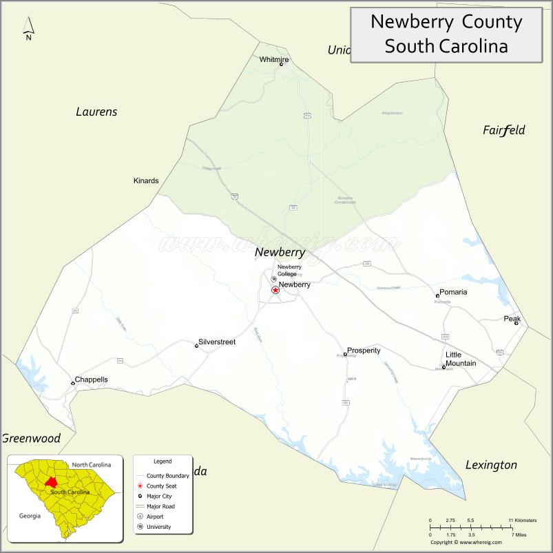
About Newberry County Map, South Carolina: The map showing the county boundary, county seat, major cities, highways, water bodies and neighbouring counties.
Related South Carolina Links
Map of Newberry County, South Carolina
Newberry County is a county located in the U.S. state of South Carolina. It's county seat is Newberry. As per 2020 census, the population of Newberry County is 37996 people and population density is square miles. According to the United States Census Bureau, the county has a total area of 647 sq mi (1,676 km2). Newberry County was established on 1785.
Newberry County Facts
| Continent | North America |
| Country | United States |
| State | South Carolina |
| County Seat | Newberry |
| Largest City/Town | Newberry |
| Established | 1785 |
| Total Area | 647.39 sq mi (1,676.74 sq km) |
| Land Area | 630.01 sq mi (1,631.74 sq km) |
| Water Area | 17.38 sq mi (45.00 sq km) |
| Population | 38,508 (Census 2020) |
| Population Density | 61.1 people per sq mi |
| Time Zone | Eastern (EST) |
| Major Highways | I-26, US-76, SC-34, SC-121 |
| Major Rivers | Saluda River, Enoree River |
| Neighboring Counties | Laurens, Saluda, Lexington, Richland, Fairfield, Union |
| Famous For | Newberry Opera House, historic downtown, education |
| Top Attractions | Newberry Opera House, Wells Japanese Garden, Lake Murray (nearby), Lynch's Woods Park |
| Official Website | Official Website |
About Newberry County, South Carolina
Newberry County is located in the central part of South Carolina in the United States and was established in 1785. The county seat is Newberry, which is also the largest city. The county lies in the Midlands region and is known for its rich history, vibrant arts scene centered around the Newberry Opera House, and its scenic countryside.
Cities and Towns in Newberry County, South Carolina
| City/Town | Population (Census 2020) | Latitude & Longitude |
|---|---|---|
| Newberry (county seat) | 10,277 | 34.2740N, 81.6187W |
| Prosperity | 1,179 | 34.2104N, 81.5334W |
| Silverstreet | 200+ | 34.2050N, 81.7800W |
| Whitmire | 1,400+ | 34.4993N, 81.6110W |
| Pomaria | 200+ | 34.2720N, 81.4090W |
| Peak (partly) | 100+ | 34.2400N, 81.3300W |
| Stoney Hill (CDP) | ~N/A | 34.2000N, 81.5200W |
Golf Courses in Newberry County, South Carolina
| Golf Course | Location | Latitude & Longitude |
|---|---|---|
| Mid-Carolina Club | Prosperity | 34.1805N, 81.5600W |
| Newberry Country Club | Newberry | 34.2700N, 81.6200W |
Roads and Highways in Newberry County, South Carolina
The county is served by major highways connecting it to Columbia and the Upstate region.
- I-26 - connects Newberry County to Columbia and Spartanburg
- US-76 - runs east-west through the county
- SC-34 - connects Newberry to surrounding counties
- SC-121 - links the county to Union and Saluda
Neighboring Counties of Newberry County
- Laurens County (northwest)
- Union County (north)
- Fairfield County (east)
- Richland County (east)
- Lexington County (south)
- Saluda County (west)
Top Attractions in Newberry County, South Carolina
The county offers a mix of cultural and outdoor attractions.
- Newberry Opera House - historic performing arts venue
- Wells Japanese Garden - scenic garden in downtown Newberry
- Lynch�s Woods Park - hiking, biking, and nature trails
- Lake Murray (nearby) - boating and recreation
- Newberry College - historic campus
- Enoree River - outdoor recreation and scenic views
Distance from Newberry County to Nearby Cities
- Newberry to Columbia - 40 mi (64 km)
- Newberry to Greenville - 75 mi (121 km)
- Newberry to Spartanburg - 60 mi (97 km)
- Newberry to Charlotte - 100 mi (161 km)
- Newberry to Charleston - 120 mi (193 km)
FAQs about Newberry County
Newberry County is located in the central Midlands region of South Carolina.
The population of Newberry County is 38,508 according to the 2020 Census.
The county is known for the Newberry Opera House, historic downtown, and cultural attractions.
Major highways include I-26, US-76, SC-34, and SC-121.
Yes, Mid-Carolina Club and Newberry Country Club are located in the county.
- Abbeville County Map
- Aiken County Map
- Allendale County Map
- Anderson County Map
- Bamberg County Map
- Barnwell County Map
- Beaufort County Map
- Berkeley County Map
- Calhoun County Map
- Charleston County Map
- Cherokee County Map
- Chester County Map
- Chesterfield County Map
- Clarendon County Map
- Colleton County Map
- Darlington County Map
- Dillon County Map
- Dorchester County Map
- Edgefield County Map
- Fairfield County Map
- Florence County Map
- Georgetown County Map
- Greenville County Map
- Greenwood County Map
- Hampton County Map
- Horry County Map
- Jasper County Map
- Kershaw County Map
- Lancaster County Map
- Laurens County Map
- Lee County Map
- Lexington County Map
- McCormick County Map
- Marion County Map
- Marlboro County Map
- Newberry County Map
- Oconee County Map
- Orangeburg County Map
- Pickens County Map
- Richland County Map
- Saluda County Map
- Spartanburg County Map
- Sumter County Map
- Union County Map
- Williamsburg County Map
- York County Map
- Alabama Counties
- Alaska boroughs
- Arizona Counties
- Arkansas Counties
- California County Map
- Colorado Counties
- Connecticut Counties
- Delaware Counties
- Florida County Map
- Georgia County Map
- Hawaii Counties
- Idaho Counties
- Illinois Counties
- Indiana Counties
- Iowa Counties
- Kansas Counties
- Kentucky Counties
- Louisiana Counties
- Maine Counties
- Maryland Counties
- Massachusetts Counties
- Michigan County Map
- Minnesota Counties
- Mississippi Counties
- Missouri Counties
- Montana Counties
- Nebraska Counties
- Nevada Counties
- New York Counties
- New Hampshire Counties
- New Jersey Counties
- New Mexico Counties
- North Carolina Counties
- North Dakota Counties
- Ohio County Map
- Oklahoma Counties
- Oregon Counties
- Pennsylvania Counties
- Rhode Island Counties
- South Carolina Counties
- South Dakota Counties
- Map of Tennessee
- Texas County Map
- Utah Counties
- Vermont Counties
- Virginia Counties
- Washington Counties
- West Virginia Counties
- Wisconsin Counties
- Wyoming Counties