Written and Fact-checked by Whereig Editors | Updated On: May 05, 2026 | 14:50 ET
Map of Abbeville County - Abbeville County is a county located in the U.S. state of South Carolina. Abbeville County Map showing cities, highways, important places and water bodies. Get Where is Abbeville County located in the map, major cities in Abbeville county, population, areas, and places of interest.
Map of Abbeville County, South Carolina
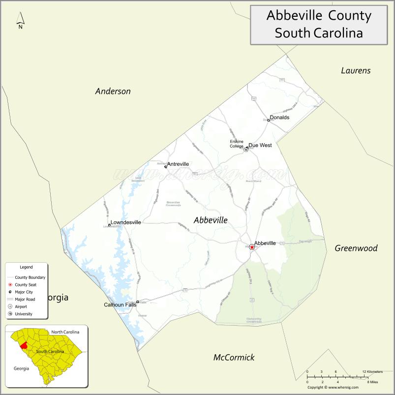
About Abbeville County Map, South Carolina: The map showing the county boundary, county seat, major cities, highways, water bodies and neighbouring counties.
Related South Carolina Links
Map of Abbeville County, South Carolina
Abbeville County is a county located in the U.S. state of South Carolina. It's county seat is Abbeville. As per 2020 census, the population of Abbeville County is 24299 people and population density is square miles. According to the United States Census Bureau, the county has a total area of 511 sq mi (1,323 km2). Abbeville County was established on 1785.
Abbeville County Facts
| Continent | North America |
| Country | United States |
| State | South Carolina |
| County Seat | Abbeville |
| Largest City/Town | Abbeville |
| Established | 1785 |
| Total Area | 511.74 sq mi (1,325.41 sq km) |
| Land Area | 491.19 sq mi (1,272.17 sq km) |
| Water Area | 20.55 sq mi (53.22 sq km) |
| Population | 24,295 (Census 2020) |
| Population Density | 49.5 people per sq mi |
| Time Zone | Eastern (EST) |
| Major Highways | US-72, SC-20, SC-28, SC-71, SC-184 |
| Major Rivers | Savannah River, Saluda River |
| Neighboring Counties | Greenville, Anderson, Laurens, Greenwood, McCormick, Elbert (GA) |
| Famous For | Historic charm, lakes, Abbeville Opera House |
| Top Attractions | Abbeville Opera House, Calhoun Falls State Park, Lake Russell, Lake Secession |
| Official Website | Official Website |
About Abbeville County, South Carolina
Abbeville County is located in the western part of South Carolina in the United States and was established in 1785. The county seat is Abbeville, which is also the largest city. The county lies in the Upstate region and features rolling hills, historic sites, and scenic lakes that make it a popular destination for both history and outdoor activities.
Cities and Towns in Abbeville County, South Carolina
| City/Town | Population (Census 2020) | Latitude & Longitude |
|---|---|---|
| Abbeville (county seat) | 4,874 | 34.1787N, 82.3790W |
| Calhoun Falls | 2,049 | 34.0929N, 82.5946W |
| Honea Path (partly) | 3,739 | 34.4462N, 82.3915W |
| Ware Shoals (partly) | 2,074 | 34.3973N, 82.2465W |
| Antreville (CDP) | 147 | 34.2896N, 82.5607W |
Golf Courses in Abbeville County, South Carolina
| Golf Course | Location | Latitude & Longitude |
|---|---|---|
| Abbeville Country Club | Abbeville | 34.1760N, 82.3740W |
| Calhoun Falls Golf Course | Calhoun Falls | 34.0915N, 82.5980W |
Roads and Highways in Abbeville County, South Carolina
The county is connected by several important highways that link it to nearby regions.
- US-72 - east-west corridor connecting Greenwood and Anderson
- SC-20 - runs through Abbeville and connects to Laurens County
- SC-28 - links the county to Georgia and McCormick County
- SC-71 - serves local rural communities
- SC-184 - connects Abbeville to Due West
Neighboring Counties of Abbeville County
- Greenville County (north)
- Anderson County (north)
- Laurens County (northeast)
- Greenwood County (east)
- McCormick County (south)
- Elbert County, Georgia (west)
Top Attractions in Abbeville County, South Carolina
Visitors can enjoy a blend of history, nature, and local culture.
- Abbeville Opera House - historic performing arts venue in downtown
- Calhoun Falls State Park - popular for camping, fishing, and lake views
- Lake Russell - excellent spot for boating and fishing
- Lake Secession - scenic lake for relaxing and water recreation
- Burt-Stark Mansion - historic Civil War landmark
- Historic Abbeville Square - charming shops and historic buildings
- Long Cane Scenic Area - natural forest area with hiking opportunities
Distance from Abbeville County to Nearby Cities
- Abbeville to Greenwood - 15 mi (24 km)
- Abbeville to Anderson - 30 mi (48 km)
- Abbeville to Greenville - 45 mi (72 km)
- Abbeville to Columbia - 86 mi (138 km)
- Abbeville to Augusta - 60 mi (97 km)
FAQs about Abbeville County
Abbeville County is located in the western part of South Carolina near the Georgia border in the Upstate region.
The population of Abbeville County is 24,295 according to the 2020 Census.
It is known for its historic downtown, lakes, outdoor recreation, and the Abbeville Opera House.
Major highways include US-72, SC-20, SC-28, SC-71, and SC-184.
Yes, there are golf courses such as Abbeville Country Club and Calhoun Falls Golf Course.
- Abbeville County Map
- Aiken County Map
- Allendale County Map
- Anderson County Map
- Bamberg County Map
- Barnwell County Map
- Beaufort County Map
- Berkeley County Map
- Calhoun County Map
- Charleston County Map
- Cherokee County Map
- Chester County Map
- Chesterfield County Map
- Clarendon County Map
- Colleton County Map
- Darlington County Map
- Dillon County Map
- Dorchester County Map
- Edgefield County Map
- Fairfield County Map
- Florence County Map
- Georgetown County Map
- Greenville County Map
- Greenwood County Map
- Hampton County Map
- Horry County Map
- Jasper County Map
- Kershaw County Map
- Lancaster County Map
- Laurens County Map
- Lee County Map
- Lexington County Map
- McCormick County Map
- Marion County Map
- Marlboro County Map
- Newberry County Map
- Oconee County Map
- Orangeburg County Map
- Pickens County Map
- Richland County Map
- Saluda County Map
- Spartanburg County Map
- Sumter County Map
- Union County Map
- Williamsburg County Map
- York County Map
- Alabama Counties
- Alaska boroughs
- Arizona Counties
- Arkansas Counties
- California County Map
- Colorado Counties
- Connecticut Counties
- Delaware Counties
- Florida County Map
- Georgia County Map
- Hawaii Counties
- Idaho Counties
- Illinois Counties
- Indiana Counties
- Iowa Counties
- Kansas Counties
- Kentucky Counties
- Louisiana Counties
- Maine Counties
- Maryland Counties
- Massachusetts Counties
- Michigan County Map
- Minnesota Counties
- Mississippi Counties
- Missouri Counties
- Montana Counties
- Nebraska Counties
- Nevada Counties
- New York Counties
- New Hampshire Counties
- New Jersey Counties
- New Mexico Counties
- North Carolina Counties
- North Dakota Counties
- Ohio County Map
- Oklahoma Counties
- Oregon Counties
- Pennsylvania Counties
- Rhode Island Counties
- South Carolina Counties
- South Dakota Counties
- Map of Tennessee
- Texas County Map
- Utah Counties
- Vermont Counties
- Virginia Counties
- Washington Counties
- West Virginia Counties
- Wisconsin Counties
- Wyoming Counties