Written and Fact-checked by Whereig Editors | Updated On: May 05, 2026 | 14:50 ET
Map of Beaufort County - Beaufort County is a county located in the U.S. state of South Carolina. Beaufort County Map showing cities, highways, important places and water bodies. Get Where is Beaufort County located in the map, major cities in Beaufort county, population, areas, and places of interest.
Map of Beaufort County, South Carolina
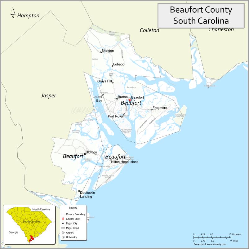
About Beaufort County Map, South Carolina: The map showing the county boundary, county seat, major cities, highways, water bodies and neighbouring counties.
Related South Carolina Links
Map of Beaufort County, South Carolina
Beaufort County is a county located in the U.S. state of South Carolina. It's county seat is Beaufort. As per 2020 census, the population of Beaufort County is 191748 people and population density is square miles. According to the United States Census Bureau, the county has a total area of 576 sq mi (1,492 km2). Beaufort County was established on 1769.
Beaufort County Facts
| Continent | North America |
| Country | United States |
| State | South Carolina |
| County Seat | Beaufort |
| Largest City/Town | Hilton Head Island |
| Established | 1769 |
| Total Area | 923.42 sq mi (2,390.66 sq km) |
| Land Area | 576.64 sq mi (1,493.50 sq km) |
| Water Area | 346.78 sq mi (897.16 sq km) |
| Population | 187,117 (Census 2020) |
| Population Density | 324.6 people per sq mi |
| Time Zone | Eastern (EST) |
| Major Highways | I-95, US-21, US-278, SC-170 |
| Major Rivers | Broad River, Beaufort River, Coosaw River |
| Neighboring Counties | Jasper, Hampton, Colleton |
| Famous For | Hilton Head Island, coastal tourism, historic Beaufort |
| Top Attractions | Hilton Head Beaches, Hunting Island State Park, Historic Beaufort, Harbour Town Lighthouse |
| Official Website | Official Website |
About Beaufort County, South Carolina
Beaufort County is located in the southern coastal part of South Carolina in the United States and was established in 1769. The county seat is Beaufort, while the largest town is Hilton Head Island. The county is part of the Lowcountry region and is known for its coastal landscapes, barrier islands, tidal marshes, and strong tourism industry.
Cities and Towns in Beaufort County, South Carolina
| City/Town | Population (Census 2020) | Latitude & Longitude |
|---|---|---|
| Beaufort (county seat) | 13,607 | 32.4316N, 80.6698W |
| Hilton Head Island | 38,068 | 32.2163N, 80.7526W |
| Bluffton | 27,716 | 32.2371N, 80.8604W |
| Port Royal | 14,064 | 32.3793N, 80.6926W |
| Yemassee (partly) | 1,107 | 32.6846N, 80.8482W |
| Shell Point (CDP) | 8,567 | 32.3775N, 80.7415W |
| Burton (CDP) | 7,615 | 32.4371N, 80.7410W |
| Ladys Island (CDP) | 13,000+ | 32.4574N, 80.6351W |
| St. Helena Island (CDP) | 8,875 | 32.3910N, 80.5601W |
Golf Courses in Beaufort County, South Carolina
| Golf Course | Location | Latitude & Longitude |
|---|---|---|
| Harbour Town Golf Links | Hilton Head Island | 32.1373N, 80.8044W |
| Sea Pines Country Club | Hilton Head Island | 32.1355N, 80.7993W |
| Heron Point by Pete Dye | Hilton Head Island | 32.1370N, 80.8050W |
| Palmetto Hall Plantation Club | Hilton Head Island | 32.2150N, 80.7245W |
| Old South Golf Links | Bluffton | 32.2467N, 80.8295W |
| Crescent Pointe Golf Club | Bluffton | 32.2341N, 80.8567W |
| Secession Golf Club | Beaufort | 32.3735N, 80.5665W |
| Sanctuary Golf Club | Cat Island | 32.4548N, 80.6330W |
Roads and Highways in Beaufort County, South Carolina
The county is well connected by highways linking coastal areas to inland South Carolina and Georgia.
- I-95 - major interstate running north-south through the western part of the county
- US-21 - connects Beaufort, Port Royal, and Hunting Island
- US-278 - key route linking Hilton Head Island to Bluffton and I-95
- SC-170 - connects Beaufort to Bluffton and Jasper County
Neighboring Counties of Beaufort County
- Colleton County (north)
- Hampton County (northwest)
- Jasper County (west)
Top Attractions in Beaufort County, South Carolina
The county is one of South Carolina�s top tourist destinations with coastal beauty and historic charm.
- Hilton Head Island Beaches - famous for wide sandy beaches and resorts
- Hunting Island State Park - lighthouse, beaches, and maritime forest
- Historic Downtown Beaufort - charming waterfront district
- Harbour Town Lighthouse - iconic landmark with scenic views
- Pinckney Island National Wildlife Refuge - wildlife and walking trails
- Mitchelville Freedom Park - historic site of a Civil War-era freedmen�s town
- Port Royal Boardwalk - scenic waterfront views and fishing pier
- Coastal Discovery Museum - exhibits on Lowcountry history and ecology
Distance from Beaufort County to Nearby Cities
- Beaufort to Savannah - 40 mi (64 km)
- Beaufort to Charleston - 70 mi (113 km)
- Beaufort to Columbia - 140 mi (225 km)
- Beaufort to Jacksonville - 160 mi (257 km)
- Beaufort to Atlanta - 250 mi (402 km)
FAQs about Beaufort County
Beaufort County is located in the southern coastal region of South Carolina along the Atlantic Ocean.
The population of Beaufort County is 187,117 according to the 2020 Census.
The county is known for Hilton Head Island, coastal tourism, beaches, and historic Beaufort.
Major highways include I-95, US-21, US-278, and SC-170.
Yes, Beaufort County has many golf courses, especially on Hilton Head Island, including Harbour Town Golf Links and Sea Pines Country Club.
- Abbeville County Map
- Aiken County Map
- Allendale County Map
- Anderson County Map
- Bamberg County Map
- Barnwell County Map
- Beaufort County Map
- Berkeley County Map
- Calhoun County Map
- Charleston County Map
- Cherokee County Map
- Chester County Map
- Chesterfield County Map
- Clarendon County Map
- Colleton County Map
- Darlington County Map
- Dillon County Map
- Dorchester County Map
- Edgefield County Map
- Fairfield County Map
- Florence County Map
- Georgetown County Map
- Greenville County Map
- Greenwood County Map
- Hampton County Map
- Horry County Map
- Jasper County Map
- Kershaw County Map
- Lancaster County Map
- Laurens County Map
- Lee County Map
- Lexington County Map
- McCormick County Map
- Marion County Map
- Marlboro County Map
- Newberry County Map
- Oconee County Map
- Orangeburg County Map
- Pickens County Map
- Richland County Map
- Saluda County Map
- Spartanburg County Map
- Sumter County Map
- Union County Map
- Williamsburg County Map
- York County Map
- Alabama Counties
- Alaska boroughs
- Arizona Counties
- Arkansas Counties
- California County Map
- Colorado Counties
- Connecticut Counties
- Delaware Counties
- Florida County Map
- Georgia County Map
- Hawaii Counties
- Idaho Counties
- Illinois Counties
- Indiana Counties
- Iowa Counties
- Kansas Counties
- Kentucky Counties
- Louisiana Counties
- Maine Counties
- Maryland Counties
- Massachusetts Counties
- Michigan County Map
- Minnesota Counties
- Mississippi Counties
- Missouri Counties
- Montana Counties
- Nebraska Counties
- Nevada Counties
- New York Counties
- New Hampshire Counties
- New Jersey Counties
- New Mexico Counties
- North Carolina Counties
- North Dakota Counties
- Ohio County Map
- Oklahoma Counties
- Oregon Counties
- Pennsylvania Counties
- Rhode Island Counties
- South Carolina Counties
- South Dakota Counties
- Map of Tennessee
- Texas County Map
- Utah Counties
- Vermont Counties
- Virginia Counties
- Washington Counties
- West Virginia Counties
- Wisconsin Counties
- Wyoming Counties