Written and Fact-checked by Whereig Editors | Updated On: May 05, 2026 | 14:50 ET
Map of Marlboro County - Marlboro County is a county located in the U.S. state of South Carolina. Marlboro County Map showing cities, highways, important places and water bodies. Get Where is Marlboro County located in the map, major cities in Marlboro county, population, areas, and places of interest.
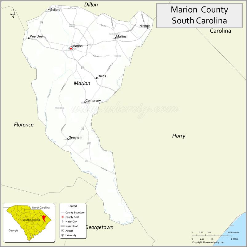
Map of Marion County, South Carolina
About Marlboro County Map, South Carolina: The map showing the county boundary, county seat, major cities, highways, water bodies and neighbouring counties.
Related South Carolina Links
Map of Marion County, South Carolina
Marion County is a county located in the U.S. state of South Carolina. It's county seat is Marion. As per 2020 census, the population of Marion County is 28784 people and population density is square miles. According to the United States Census Bureau, the county has a total area of 494 sq mi (1,279 km2). Marion County was established on 1800.
Marion County Facts
| Continent | North America |
| Country | United States |
| State | South Carolina |
| County Seat | Marion |
| Largest City/Town | Marion |
| Established | 1785 |
| Total Area | 494.30 sq mi (1,280.24 sq km) |
| Land Area | 489.72 sq mi (1,268.37 sq km) |
| Water Area | 4.58 sq mi (11.87 sq km) |
| Population | 29,333 (Census 2020) |
| Population Density | 59.9 people per sq mi |
| Time Zone | Eastern (EST) |
| Major Highways | US-501, US-76, SC-41, SC-576 |
| Major Rivers | Great Pee Dee River, Little Pee Dee River |
| Neighboring Counties | Dillon, Florence, Williamsburg, Georgetown, Horry |
| Famous For | Historic districts, agriculture, Pee Dee River region |
| Top Attractions | Little Pee Dee State Park, Marion Historic District, Mullins Depot Museum |
| Official Website | Official Website |
About Marion County, South Carolina
Marion County is located in the northeastern part of South Carolina in the United States and was established in 1785. The county seat is Marion, which is also the largest city. The county lies in the Pee Dee region and is known for its agricultural heritage, historic downtown areas, and proximity to major rivers that support outdoor recreation.
Cities and Towns in Marion County, South Carolina
| City/Town | Population (Census 2020) | Latitude & Longitude |
|---|---|---|
| Marion (county seat) | 6,448 | 34.1782N, 79.4009W |
| Mullins | 3,885 | 34.2052N, 79.2548W |
| Nichols | 354 | 34.2338N, 79.1406W |
| Brittons Neck (CDP) | ~N/A | 34.1200N, 79.2700W |
| Kempton (CDP) | ~N/A | 34.1500N, 79.3500W |
Golf Courses in Marion County, South Carolina
| Golf Course | Location | Latitude & Longitude |
|---|---|---|
| Fox Hollow Golf Club | Mullins | 34.2070N, 79.2600W |
| Wellman Club (nearby) | Johnsonville area | 33.8300N, 79.4500W |
Roads and Highways in Marion County, South Carolina
The county is connected by highways that support regional travel and commerce.
- US-501 - major route connecting Marion to Myrtle Beach and inland areas
- US-76 - east-west route linking Marion to Florence and Mullins
- SC-41 - connects to Georgetown and Dillon counties
- SC-576 - links rural areas within the county
Neighboring Counties of Marion County
- Dillon County (north)
- Florence County (west)
- Williamsburg County (southwest)
- Georgetown County (south)
- Horry County (east)
Top Attractions in Marion County, South Carolina
The county offers a blend of natural beauty and historic sites.
- Little Pee Dee State Park - camping, fishing, and nature trails
- Marion Historic District - preserved downtown architecture
- Mullins Depot Museum - local history and railroad heritage
- Great Pee Dee River - boating and fishing opportunities
- Little Pee Dee River - scenic paddling and wildlife viewing
- Local farms - agriculture and seasonal produce
Distance from Marion County to Nearby Cities
- Marion to Florence - 25 mi (40 km)
- Marion to Myrtle Beach - 60 mi (97 km)
- Marion to Charleston - 110 mi (177 km)
- Marion to Columbia - 100 mi (161 km)
- Marion to Wilmington - 90 mi (145 km)
FAQs about Marion County
Marion County is located in the northeastern Pee Dee region of South Carolina.
The population of Marion County is 29,333 according to the 2020 Census.
The county is known for its historic districts, agriculture, and river landscapes.
Major highways include US-501, US-76, SC-41, and SC-576.
Yes, Fox Hollow Golf Club is a known golf course in the county.
- Abbeville County Map
- Aiken County Map
- Allendale County Map
- Anderson County Map
- Bamberg County Map
- Barnwell County Map
- Beaufort County Map
- Berkeley County Map
- Calhoun County Map
- Charleston County Map
- Cherokee County Map
- Chester County Map
- Chesterfield County Map
- Clarendon County Map
- Colleton County Map
- Darlington County Map
- Dillon County Map
- Dorchester County Map
- Edgefield County Map
- Fairfield County Map
- Florence County Map
- Georgetown County Map
- Greenville County Map
- Greenwood County Map
- Hampton County Map
- Horry County Map
- Jasper County Map
- Kershaw County Map
- Lancaster County Map
- Laurens County Map
- Lee County Map
- Lexington County Map
- McCormick County Map
- Marion County Map
- Marlboro County Map
- Newberry County Map
- Oconee County Map
- Orangeburg County Map
- Pickens County Map
- Richland County Map
- Saluda County Map
- Spartanburg County Map
- Sumter County Map
- Union County Map
- Williamsburg County Map
- York County Map
- Alabama Counties
- Alaska boroughs
- Arizona Counties
- Arkansas Counties
- California County Map
- Colorado Counties
- Connecticut Counties
- Delaware Counties
- Florida County Map
- Georgia County Map
- Hawaii Counties
- Idaho Counties
- Illinois Counties
- Indiana Counties
- Iowa Counties
- Kansas Counties
- Kentucky Counties
- Louisiana Counties
- Maine Counties
- Maryland Counties
- Massachusetts Counties
- Michigan County Map
- Minnesota Counties
- Mississippi Counties
- Missouri Counties
- Montana Counties
- Nebraska Counties
- Nevada Counties
- New York Counties
- New Hampshire Counties
- New Jersey Counties
- New Mexico Counties
- North Carolina Counties
- North Dakota Counties
- Ohio County Map
- Oklahoma Counties
- Oregon Counties
- Pennsylvania Counties
- Rhode Island Counties
- South Carolina Counties
- South Dakota Counties
- Map of Tennessee
- Texas County Map
- Utah Counties
- Vermont Counties
- Virginia Counties
- Washington Counties
- West Virginia Counties
- Wisconsin Counties
- Wyoming Counties