Written and Fact-checked by Whereig Editors | Updated On: May 05, 2026 | 14:50 ET
Map of Laurens County - Laurens County is a county located in the U.S. state of South Carolina. Laurens County Map showing cities, highways, important places and water bodies. Get Where is Laurens County located in the map, major cities in Laurens county, population, areas, and places of interest.
Map of Laurens County, South Carolina
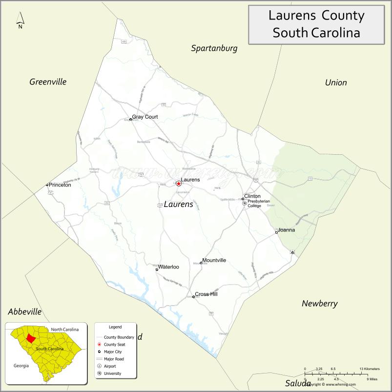
About Laurens County Map, South Carolina: The map showing the county boundary, county seat, major cities, highways, water bodies and neighbouring counties.
Related South Carolina Links
Map of Laurens County, South Carolina
Laurens County is a county located in the U.S. state of South Carolina. It's county seat is Laurens. As per 2020 census, the population of Laurens County is 67803 people and population density is square miles. According to the United States Census Bureau, the county has a total area of 724 sq mi (1,875 km2). Laurens County was established on 1785.
Laurens County Facts
| Continent | North America |
| Country | United States |
| State | South Carolina |
| County Seat | Laurens |
| Largest City/Town | Clinton |
| Established | 1785 |
| Total Area | 722.70 sq mi (1,872.77 sq km) |
| Land Area | 714.79 sq mi (1,851.31 sq km) |
| Water Area | 7.91 sq mi (20.49 sq km) |
| Population | 67,539 (Census 2020) |
| Population Density | 94.5 people per sq mi |
| Time Zone | Eastern (EST) |
| Major Highways | I-385, US-76, US-221, SC-56, SC-72 |
| Major Rivers | Enoree River, Saluda River |
| Neighboring Counties | Greenville, Spartanburg, Union, Newberry, Greenwood, Abbeville |
| Famous For | Historic sites, Presbyterian College, rural landscapes |
| Top Attractions | Rose Hill Plantation State Historic Site, Lake Rabon Park, Musgrove Mill State Historic Site |
| Official Website | Official Website |
About Laurens County, South Carolina
Laurens County is located in the northwestern part of South Carolina in the United States and was established in 1785. The county seat is Laurens, while the largest city is Clinton. The county lies in the Upstate region and is known for its historical significance, rural landscapes, and educational institutions such as Presbyterian College.
Cities and Towns in Laurens County, South Carolina
| City/Town | Population (Census 2020) | Latitude & Longitude |
|---|---|---|
| Clinton | 8,091 | 34.4723N, 81.8801W |
| Laurens (county seat) | 9,163 | 34.4993N, 82.0143W |
| Gray Court | 800 | 34.6068N, 82.1126W |
| Waterloo | 172 | 34.3320N, 82.0565W |
| Fountain Inn (partly) | 10,000+ | 34.6890N, 82.1957W |
| Cross Hill (partly) | 600+ | 34.2950N, 81.9800W |
| Mountville (CDP) | ~N/A | 34.3820N, 81.9800W |
Golf Courses in Laurens County, South Carolina
| Golf Course | Location | Latitude & Longitude |
|---|---|---|
| Laurens County Club | Laurens | 34.4970N, 82.0105W |
| Musgrove Mill Golf Club | Clinton area | 34.4725N, 81.9100W |
| Rolling S Golf Club | Gray Court | 34.6080N, 82.1200W |
Roads and Highways in Laurens County, South Carolina
The county is connected by highways that provide access to surrounding Upstate regions.
- I-385 - connects Laurens County to Greenville and Columbia
- US-76 - runs through Clinton and connects to nearby counties
- US-221 - links Laurens to Spartanburg and Greenwood
- SC-56 - connects Clinton to surrounding communities
- SC-72 - major east-west route through the county
Neighboring Counties of Laurens County
- Greenville County (north)
- Spartanburg County (north)
- Union County (east)
- Newberry County (south)
- Greenwood County (southwest)
- Abbeville County (west)
Top Attractions in Laurens County, South Carolina
The county offers a mix of historical sites and outdoor recreation.
- Rose Hill Plantation State Historic Site - historic plantation and grounds
- Musgrove Mill State Historic Site - Revolutionary War battlefield
- Lake Rabon Park - camping, fishing, and trails
- Presbyterian College - historic campus in Clinton
- Enoree River - kayaking and outdoor recreation
- Downtown Laurens - shops, dining, and local events
Distance from Laurens County to Nearby Cities
- Laurens to Greenville - 35 mi (56 km)
- Laurens to Columbia - 80 mi (129 km)
- Laurens to Spartanburg - 40 mi (64 km)
- Laurens to Charlotte - 100 mi (161 km)
- Laurens to Atlanta - 150 mi (241 km)
FAQs about Laurens County
Laurens County is located in the northwestern Upstate region of South Carolina.
The population of Laurens County is 67,539 according to the 2020 Census.
The county is known for its historic sites, rural landscapes, and educational institutions.
Major highways include I-385, US-76, US-221, SC-56, and SC-72.
Yes, Laurens County Club and Musgrove Mill Golf Club are located in the county.
- Abbeville County Map
- Aiken County Map
- Allendale County Map
- Anderson County Map
- Bamberg County Map
- Barnwell County Map
- Beaufort County Map
- Berkeley County Map
- Calhoun County Map
- Charleston County Map
- Cherokee County Map
- Chester County Map
- Chesterfield County Map
- Clarendon County Map
- Colleton County Map
- Darlington County Map
- Dillon County Map
- Dorchester County Map
- Edgefield County Map
- Fairfield County Map
- Florence County Map
- Georgetown County Map
- Greenville County Map
- Greenwood County Map
- Hampton County Map
- Horry County Map
- Jasper County Map
- Kershaw County Map
- Lancaster County Map
- Laurens County Map
- Lee County Map
- Lexington County Map
- McCormick County Map
- Marion County Map
- Marlboro County Map
- Newberry County Map
- Oconee County Map
- Orangeburg County Map
- Pickens County Map
- Richland County Map
- Saluda County Map
- Spartanburg County Map
- Sumter County Map
- Union County Map
- Williamsburg County Map
- York County Map
- Alabama Counties
- Alaska boroughs
- Arizona Counties
- Arkansas Counties
- California County Map
- Colorado Counties
- Connecticut Counties
- Delaware Counties
- Florida County Map
- Georgia County Map
- Hawaii Counties
- Idaho Counties
- Illinois Counties
- Indiana Counties
- Iowa Counties
- Kansas Counties
- Kentucky Counties
- Louisiana Counties
- Maine Counties
- Maryland Counties
- Massachusetts Counties
- Michigan County Map
- Minnesota Counties
- Mississippi Counties
- Missouri Counties
- Montana Counties
- Nebraska Counties
- Nevada Counties
- New York Counties
- New Hampshire Counties
- New Jersey Counties
- New Mexico Counties
- North Carolina Counties
- North Dakota Counties
- Ohio County Map
- Oklahoma Counties
- Oregon Counties
- Pennsylvania Counties
- Rhode Island Counties
- South Carolina Counties
- South Dakota Counties
- Map of Tennessee
- Texas County Map
- Utah Counties
- Vermont Counties
- Virginia Counties
- Washington Counties
- West Virginia Counties
- Wisconsin Counties
- Wyoming Counties