Written and Fact-checked by Whereig Editors | Updated On: May 05, 2026 | 14:50 ET
Map of Lancaster County - Lancaster County is a county located in the U.S. state of South Carolina. Lancaster County Map showing cities, highways, important places and water bodies. Get Where is Lancaster County located in the map, major cities in Lancaster county, population, areas, and places of interest.
Map of Lancaster County, South Carolina
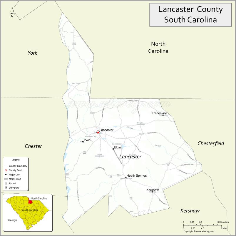
About Lancaster County Map, South Carolina: The map showing the county boundary, county seat, major cities, highways, water bodies and neighbouring counties.
Related South Carolina Links
Map of Lancaster County, South Carolina
Lancaster County is a county located in the U.S. state of South Carolina. It's county seat is Lancaster. As per 2020 census, the population of Lancaster County is 100336 people and population density is square miles. According to the United States Census Bureau, the county has a total area of 555 sq mi (1,437 km2). Lancaster County was established on 1798.
Lancaster County Facts
| Continent | North America |
| Country | United States |
| State | South Carolina |
| County Seat | Lancaster |
| Largest City/Town | Lancaster |
| Established | 1785 |
| Total Area | 555.12 sq mi (1,437.74 sq km) |
| Land Area | 549.16 sq mi (1,422.33 sq km) |
| Water Area | 5.96 sq mi (15.41 sq km) |
| Population | 96,016 (Census 2020) |
| Population Density | 174.8 people per sq mi |
| Time Zone | Eastern (EST) |
| Major Highways | US-521, SC-9, SC-200, SC-522 |
| Major Rivers | Catawba River, Lynches River |
| Neighboring Counties | York, Chester, Kershaw, Chesterfield, Union (NC), Mecklenburg (NC) |
| Famous For | Red Rose City, historic sites, growing suburban communities |
| Top Attractions | Andrew Jackson State Park, Lindsay Pettus Greenway, Lancaster Historic District |
| Official Website | Official Website |
About Lancaster County, South Carolina
Lancaster County is located in the north-central part of South Carolina in the United States and was established in 1785. The county seat is Lancaster, which is also the largest city. The county lies in the Piedmont region near the North Carolina border and is known for its historic heritage, growing residential communities, and proximity to the Charlotte metropolitan area.
Cities and Towns in Lancaster County, South Carolina
| City/Town | Population (Census 2020) | Latitude & Longitude |
|---|---|---|
| Lancaster (county seat) | 9,526 | 34.7204N, 80.7701W |
| Kershaw | 1,803 | 34.5518N, 80.5831W |
| Heath Springs | 825 | 34.5932N, 80.6767W |
| Indian Land (CDP) | 30,000+ | 35.0074N, 80.8467W |
| Springdale (CDP) | 3,000+ | 34.6880N, 80.7750W |
| Irwin (CDP) | 1,200+ | 34.7350N, 80.7800W |
Golf Courses in Lancaster County, South Carolina
| Golf Course | Location | Latitude & Longitude |
|---|---|---|
| Edgewater Golf Club | Lancaster | 34.7352N, 80.7405W |
| Carolina Lakes Golf Club | Indian Land | 34.9905N, 80.8455W |
| Sun City Carolina Lakes Golf Course | Indian Land | 35.0200N, 80.8300W |
Roads and Highways in Lancaster County, South Carolina
The county is served by highways that connect it to nearby urban areas and neighboring states.
- US-521 - major route connecting Lancaster to Charlotte and Sumter
- SC-9 - connects Lancaster to Chester and North Carolina
- SC-200 - links Lancaster to Rock Hill and surrounding areas
- SC-522 - provides access to rural parts of the county
Neighboring Counties of Lancaster County
- Mecklenburg County, North Carolina (north)
- Union County, North Carolina (north)
- Chesterfield County (east)
- Kershaw County (south)
- Chester County (west)
- York County (northwest)
Top Attractions in Lancaster County, South Carolina
The county offers a mix of history, parks, and outdoor recreation.
- Andrew Jackson State Park - historic site and recreational area
- Lindsay Pettus Greenway - walking and biking trail
- Lancaster Historic District - preserved downtown area
- Catawba River - fishing, kayaking, and scenic views
- Buford Battleground - Revolutionary War site
- Red Rose Festival - annual local celebration
Distance from Lancaster County to Nearby Cities
- Lancaster to Charlotte - 40 mi (64 km)
- Lancaster to Columbia - 70 mi (113 km)
- Lancaster to Rock Hill - 25 mi (40 km)
- Lancaster to Greenville - 110 mi (177 km)
- Lancaster to Charleston - 140 mi (225 km)
FAQs about Lancaster County
Lancaster County is located in the north-central Piedmont region of South Carolina near the North Carolina border.
The population of Lancaster County is 96,016 according to the 2020 Census.
The county is known as the Red Rose City and for its historic sites and growing communities near Charlotte.
Major highways include US-521, SC-9, SC-200, and SC-522.
Yes, golf courses such as Edgewater Golf Club and Carolina Lakes Golf Club are located in the county.
- Abbeville County Map
- Aiken County Map
- Allendale County Map
- Anderson County Map
- Bamberg County Map
- Barnwell County Map
- Beaufort County Map
- Berkeley County Map
- Calhoun County Map
- Charleston County Map
- Cherokee County Map
- Chester County Map
- Chesterfield County Map
- Clarendon County Map
- Colleton County Map
- Darlington County Map
- Dillon County Map
- Dorchester County Map
- Edgefield County Map
- Fairfield County Map
- Florence County Map
- Georgetown County Map
- Greenville County Map
- Greenwood County Map
- Hampton County Map
- Horry County Map
- Jasper County Map
- Kershaw County Map
- Lancaster County Map
- Laurens County Map
- Lee County Map
- Lexington County Map
- McCormick County Map
- Marion County Map
- Marlboro County Map
- Newberry County Map
- Oconee County Map
- Orangeburg County Map
- Pickens County Map
- Richland County Map
- Saluda County Map
- Spartanburg County Map
- Sumter County Map
- Union County Map
- Williamsburg County Map
- York County Map
- Alabama Counties
- Alaska boroughs
- Arizona Counties
- Arkansas Counties
- California County Map
- Colorado Counties
- Connecticut Counties
- Delaware Counties
- Florida County Map
- Georgia County Map
- Hawaii Counties
- Idaho Counties
- Illinois Counties
- Indiana Counties
- Iowa Counties
- Kansas Counties
- Kentucky Counties
- Louisiana Counties
- Maine Counties
- Maryland Counties
- Massachusetts Counties
- Michigan County Map
- Minnesota Counties
- Mississippi Counties
- Missouri Counties
- Montana Counties
- Nebraska Counties
- Nevada Counties
- New York Counties
- New Hampshire Counties
- New Jersey Counties
- New Mexico Counties
- North Carolina Counties
- North Dakota Counties
- Ohio County Map
- Oklahoma Counties
- Oregon Counties
- Pennsylvania Counties
- Rhode Island Counties
- South Carolina Counties
- South Dakota Counties
- Map of Tennessee
- Texas County Map
- Utah Counties
- Vermont Counties
- Virginia Counties
- Washington Counties
- West Virginia Counties
- Wisconsin Counties
- Wyoming Counties