Written and Fact-checked by Whereig Editors | Updated On: May 05, 2026 | 14:50 ET
Map of Chesterfield County - Chesterfield County is a county located in the U.S. state of South Carolina. Chesterfield County Map showing cities, highways, important places and water bodies. Get Where is Chesterfield County located in the map, major cities in Chesterfield county, population, areas, and places of interest.
Map of Chesterfield County, South Carolina
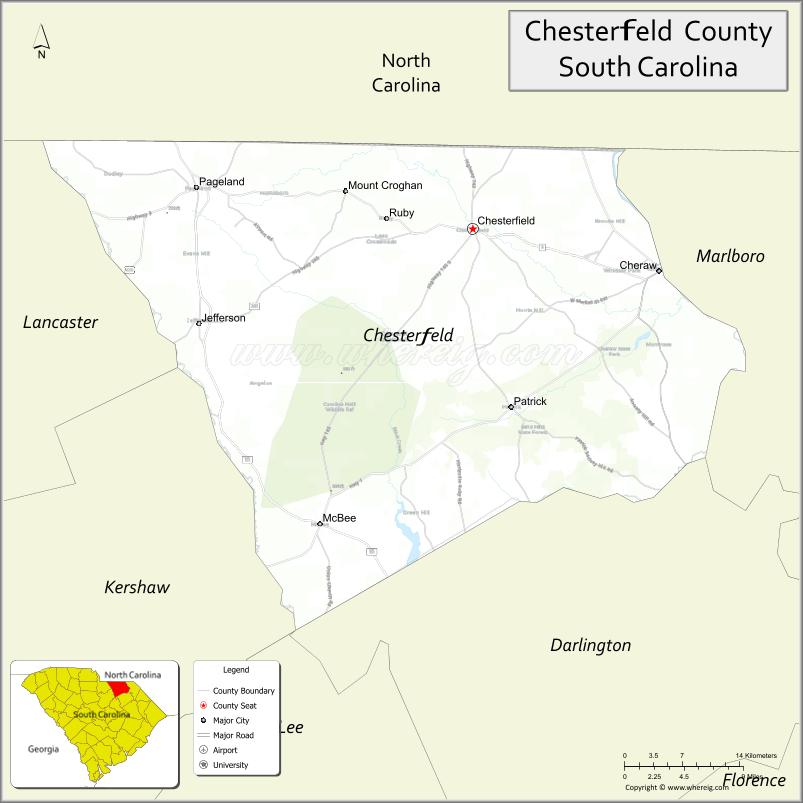
About Chesterfield County Map, South Carolina: The map showing the county boundary, county seat, major cities, highways, water bodies and neighbouring counties.
Related South Carolina Links
Map of Chesterfield County, South Carolina
Chesterfield County is a county located in the U.S. state of South Carolina. It's county seat is Chesterfield. As per 2020 census, the population of Chesterfield County is 43268 people and population density is square miles. According to the United States Census Bureau, the county has a total area of 806 sq mi (2,088 km2). Chesterfield County was established on 1798.
Chesterfield County Facts
| Continent | North America |
| Country | United States |
| State | South Carolina |
| County Seat | Chesterfield |
| Largest City/Town | Cheraw |
| Established | 1785 |
| Total Area | 805.06 sq mi (2,085.10 sq km) |
| Land Area | 799.67 sq mi (2,071.14 sq km) |
| Water Area | 5.39 sq mi (13.96 sq km) |
| Population | 43,273 (Census 2020) |
| Population Density | 54.1 people per sq mi |
| Time Zone | Eastern (EST) |
| Major Highways | US-1, US-52, US-9, SC-151, SC-145 |
| Major Rivers | Pee Dee River, Lynches River |
| Neighboring Counties | Lancaster, Chester, Darlington, Marlboro, Anson (NC), Richmond (NC) |
| Famous For | Cheraw State Park, jazz heritage, rural landscapes |
| Top Attractions | Cheraw State Park, H. Cooper Black Jr. Memorial Field Trial Area, Historic Cheraw District |
| Official Website | Official Website |
About Chesterfield County, South Carolina
Chesterfield County is located in the northeastern part of South Carolina in the United States and was established in 1785. The county seat is Chesterfield, while the largest town is Cheraw. The county lies in the Pee Dee region and features rolling sandhills, forests, rivers, and a strong cultural heritage, including its connection to jazz musician Dizzy Gillespie.
Cities and Towns in Chesterfield County, South Carolina
| City/Town | Population (Census 2020) | Latitude & Longitude |
|---|---|---|
| Cheraw | 5,040 | 34.6979N, 79.8834W |
| Chesterfield (county seat) | 1,472 | 34.7357N, 80.0884W |
| McBee (partly) | 865 | 34.4688N, 80.2573W |
| Pageland | 2,650 | 34.7735N, 80.3917W |
| Patrick | 351 | 34.5682N, 80.0373W |
| Jefferson | 753 | 34.6410N, 80.3887W |
| Mount Croghan | 170 | 34.7554N, 80.4068W |
| Ruby | 328 | 34.7393N, 80.2031W |
| Chesterfield Court House (CDP) | ~N/A | 34.7357N, 80.0884W |
Golf Courses in Chesterfield County, South Carolina
| Golf Course | Location | Latitude & Longitude |
|---|---|---|
| Green River Country Club | Chesterfield | 34.7352N, 80.0895W |
| Cheraw State Park Golf Course | Cheraw | 34.7283N, 79.8865W |
Roads and Highways in Chesterfield County, South Carolina
The county is served by several highways that connect it to surrounding regions and neighboring states.
- US-1 - north-south route connecting Cheraw to North Carolina
- US-52 - runs through Cheraw and connects to Florence
- US-9 - connects Pageland to nearby counties
- SC-151 - links to Hartsville and surrounding areas
- SC-145 - provides access to rural communities
Neighboring Counties of Chesterfield County
- Lancaster County (west)
- Chester County (southwest)
- Darlington County (south)
- Marlboro County (east)
- Anson County, North Carolina (north)
- Richmond County, North Carolina (northwest)
Top Attractions in Chesterfield County, South Carolina
The county offers natural beauty and historic charm.
- Cheraw State Park - lakes, trails, and golf course
- H. Cooper Black Jr. Memorial Field Trial Area - equestrian and outdoor events
- Historic Cheraw District - preserved architecture and local culture
- Dizzy Gillespie Homesite Park - honors the famous jazz musician
- Pee Dee River - fishing, kayaking, and scenic views
- Lynches River - natural beauty and outdoor recreation
Distance from Chesterfield County to Nearby Cities
- Cheraw to Florence - 50 mi (80 km)
- Cheraw to Columbia - 95 mi (153 km)
- Cheraw to Charlotte - 80 mi (129 km)
- Cheraw to Myrtle Beach - 90 mi (145 km)
- Cheraw to Raleigh - 130 mi (209 km)
FAQs about Chesterfield County
Chesterfield County is located in the northeastern Pee Dee region of South Carolina.
The population of Chesterfield County is 43,273 according to the 2020 Census.
The county is known for Cheraw State Park, its jazz heritage, and scenic rural landscapes.
Major highways include US-1, US-52, US-9, SC-151, and SC-145.
Yes, golf courses such as Cheraw State Park Golf Course and Green River Country Club are located in the county.
- Abbeville County Map
- Aiken County Map
- Allendale County Map
- Anderson County Map
- Bamberg County Map
- Barnwell County Map
- Beaufort County Map
- Berkeley County Map
- Calhoun County Map
- Charleston County Map
- Cherokee County Map
- Chester County Map
- Chesterfield County Map
- Clarendon County Map
- Colleton County Map
- Darlington County Map
- Dillon County Map
- Dorchester County Map
- Edgefield County Map
- Fairfield County Map
- Florence County Map
- Georgetown County Map
- Greenville County Map
- Greenwood County Map
- Hampton County Map
- Horry County Map
- Jasper County Map
- Kershaw County Map
- Lancaster County Map
- Laurens County Map
- Lee County Map
- Lexington County Map
- McCormick County Map
- Marion County Map
- Marlboro County Map
- Newberry County Map
- Oconee County Map
- Orangeburg County Map
- Pickens County Map
- Richland County Map
- Saluda County Map
- Spartanburg County Map
- Sumter County Map
- Union County Map
- Williamsburg County Map
- York County Map
- Alabama Counties
- Alaska boroughs
- Arizona Counties
- Arkansas Counties
- California County Map
- Colorado Counties
- Connecticut Counties
- Delaware Counties
- Florida County Map
- Georgia County Map
- Hawaii Counties
- Idaho Counties
- Illinois Counties
- Indiana Counties
- Iowa Counties
- Kansas Counties
- Kentucky Counties
- Louisiana Counties
- Maine Counties
- Maryland Counties
- Massachusetts Counties
- Michigan County Map
- Minnesota Counties
- Mississippi Counties
- Missouri Counties
- Montana Counties
- Nebraska Counties
- Nevada Counties
- New York Counties
- New Hampshire Counties
- New Jersey Counties
- New Mexico Counties
- North Carolina Counties
- North Dakota Counties
- Ohio County Map
- Oklahoma Counties
- Oregon Counties
- Pennsylvania Counties
- Rhode Island Counties
- South Carolina Counties
- South Dakota Counties
- Map of Tennessee
- Texas County Map
- Utah Counties
- Vermont Counties
- Virginia Counties
- Washington Counties
- West Virginia Counties
- Wisconsin Counties
- Wyoming Counties