Written and Fact-checked by Whereig Editors | Updated On: May 05, 2026 | 14:50 ET
Map of Florence County - Florence County is a county located in the U.S. state of South Carolina. Florence County Map showing cities, highways, important places and water bodies. Get Where is Florence County located in the map, major cities in Florence county, population, areas, and places of interest.
Map of Florence County, South Carolina
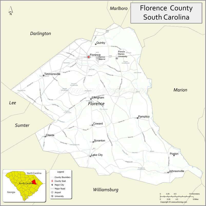
About Florence County Map, South Carolina: The map showing the county boundary, county seat, major cities, highways, water bodies and neighbouring counties.
Related South Carolina Links
Map of Florence County, South Carolina
Florence County is a county located in the U.S. state of South Carolina. It's county seat is Florence. As per 2020 census, the population of Florence County is 136504 people and population density is square miles. According to the United States Census Bureau, the county has a total area of 804 sq mi (2,082 km2). Florence County was established on 1888.
Florence County Facts
| Continent | North America |
| Country | United States |
| State | South Carolina |
| County Seat | Florence |
| Largest City/Town | Florence |
| Established | 1888 |
| Total Area | 803.61 sq mi (2,080.34 sq km) |
| Land Area | 800.95 sq mi (2,074.46 sq km) |
| Water Area | 2.66 sq mi (6.88 sq km) |
| Population | 137,059 (Census 2020) |
| Population Density | 171.1 people per sq mi |
| Time Zone | Eastern (EST) |
| Major Highways | I-95, I-20, US-52, US-76, US-301, SC-327 |
| Major Rivers | Great Pee Dee River, Lynches River |
| Neighboring Counties | Darlington, Marion, Dillon, Williamsburg, Clarendon, Lee |
| Famous For | Transportation hub, healthcare, education |
| Top Attractions | Florence Veterans Park, Florence County Museum, Timrod Park, Magnolia Mall |
| Official Website | Official Website |
About Florence County, South Carolina
Florence County is located in the northeastern part of South Carolina in the United States and was established in 1888. The county seat is Florence, which is also the largest city. The county lies in the Pee Dee region and is known as a major transportation hub, with key interstate connections, as well as its role in healthcare, education, and commerce.
Cities and Towns in Florence County, South Carolina
| City/Town | Population (Census 2020) | Latitude & Longitude |
|---|---|---|
| Florence (county seat) | 39,899 | 34.1954N, 79.7626W |
| Lake City | 6,449 | 33.8710N, 79.7553W |
| Johnsonville | 1,413 | 33.8174N, 79.4461W |
| Pamplico | 1,226 | 33.9960N, 79.5703W |
| Quinby | 1,800 | 34.2262N, 79.7653W |
| Timmonsville | 2,339 | 34.1346N, 79.9406W |
| Scranton | 890 | 33.9196N, 79.7487W |
| Olanta | 563 | 33.9360N, 79.9275W |
| Coward | 850 | 33.9702N, 79.7468W |
| Effingham (CDP) | 750 | 34.0625N, 79.7535W |
Golf Courses in Florence County, South Carolina
| Golf Course | Location | Latitude & Longitude |
|---|---|---|
| Traces Golf Club | Florence | 34.2352N, 79.8015W |
| Florence Country Club | Florence | 34.1950N, 79.7802W |
| The Country Club of South Carolina | Florence | 34.1738N, 79.7890W |
Roads and Highways in Florence County, South Carolina
The county is a major transportation hub with several key highways intersecting in the region.
- I-95 - major north-south interstate through the county
- I-20 - connects Florence to Columbia and beyond
- US-52 - runs through Florence and connects to Charleston
- US-76 - east-west route linking Florence to Myrtle Beach
- US-301 - parallels I-95 through the county
- SC-327 - connects local communities within the county
Neighboring Counties of Florence County
- Darlington County (north)
- Dillon County (north)
- Marion County (east)
- Williamsburg County (south)
- Clarendon County (southwest)
- Lee County (west)
Top Attractions in Florence County, South Carolina
The county offers parks, museums, and cultural attractions.
- Florence Veterans Park - popular public park and gathering place
- Florence County Museum - exhibits on art and local history
- Timrod Park - historic park with trails and gardens
- Magnolia Mall - shopping and entertainment destination
- Moore Farms Botanical Garden (nearby) - scenic gardens and landscapes
- Great Pee Dee River - outdoor recreation and fishing
Distance from Florence County to Nearby Cities
- Florence to Myrtle Beach - 70 mi (113 km)
- Florence to Columbia - 80 mi (129 km)
- Florence to Charleston - 130 mi (209 km)
- Florence to Charlotte - 110 mi (177 km)
- Florence to Raleigh - 140 mi (225 km)
FAQs about Florence County
Florence County is located in the northeastern Pee Dee region of South Carolina.
The population of Florence County is 137,059 according to the 2020 Census.
The county is known as a transportation hub with strong healthcare, education, and commerce sectors.
Major highways include I-95, I-20, US-52, US-76, US-301, and SC-327.
Yes, golf courses such as Traces Golf Club and Florence Country Club are located in the county.
- Abbeville County Map
- Aiken County Map
- Allendale County Map
- Anderson County Map
- Bamberg County Map
- Barnwell County Map
- Beaufort County Map
- Berkeley County Map
- Calhoun County Map
- Charleston County Map
- Cherokee County Map
- Chester County Map
- Chesterfield County Map
- Clarendon County Map
- Colleton County Map
- Darlington County Map
- Dillon County Map
- Dorchester County Map
- Edgefield County Map
- Fairfield County Map
- Florence County Map
- Georgetown County Map
- Greenville County Map
- Greenwood County Map
- Hampton County Map
- Horry County Map
- Jasper County Map
- Kershaw County Map
- Lancaster County Map
- Laurens County Map
- Lee County Map
- Lexington County Map
- McCormick County Map
- Marion County Map
- Marlboro County Map
- Newberry County Map
- Oconee County Map
- Orangeburg County Map
- Pickens County Map
- Richland County Map
- Saluda County Map
- Spartanburg County Map
- Sumter County Map
- Union County Map
- Williamsburg County Map
- York County Map
- Alabama Counties
- Alaska boroughs
- Arizona Counties
- Arkansas Counties
- California County Map
- Colorado Counties
- Connecticut Counties
- Delaware Counties
- Florida County Map
- Georgia County Map
- Hawaii Counties
- Idaho Counties
- Illinois Counties
- Indiana Counties
- Iowa Counties
- Kansas Counties
- Kentucky Counties
- Louisiana Counties
- Maine Counties
- Maryland Counties
- Massachusetts Counties
- Michigan County Map
- Minnesota Counties
- Mississippi Counties
- Missouri Counties
- Montana Counties
- Nebraska Counties
- Nevada Counties
- New York Counties
- New Hampshire Counties
- New Jersey Counties
- New Mexico Counties
- North Carolina Counties
- North Dakota Counties
- Ohio County Map
- Oklahoma Counties
- Oregon Counties
- Pennsylvania Counties
- Rhode Island Counties
- South Carolina Counties
- South Dakota Counties
- Map of Tennessee
- Texas County Map
- Utah Counties
- Vermont Counties
- Virginia Counties
- Washington Counties
- West Virginia Counties
- Wisconsin Counties
- Wyoming Counties