Written and Fact-checked by Whereig Editors | Updated On: May 05, 2026 | 14:50 ET
Map of Dillon County - Dillon County is a county located in the U.S. state of South Carolina. Dillon County Map showing cities, highways, important places and water bodies. Get Where is Dillon County located in the map, major cities in Dillon county, population, areas, and places of interest.
Map of Dillon County, South Carolina
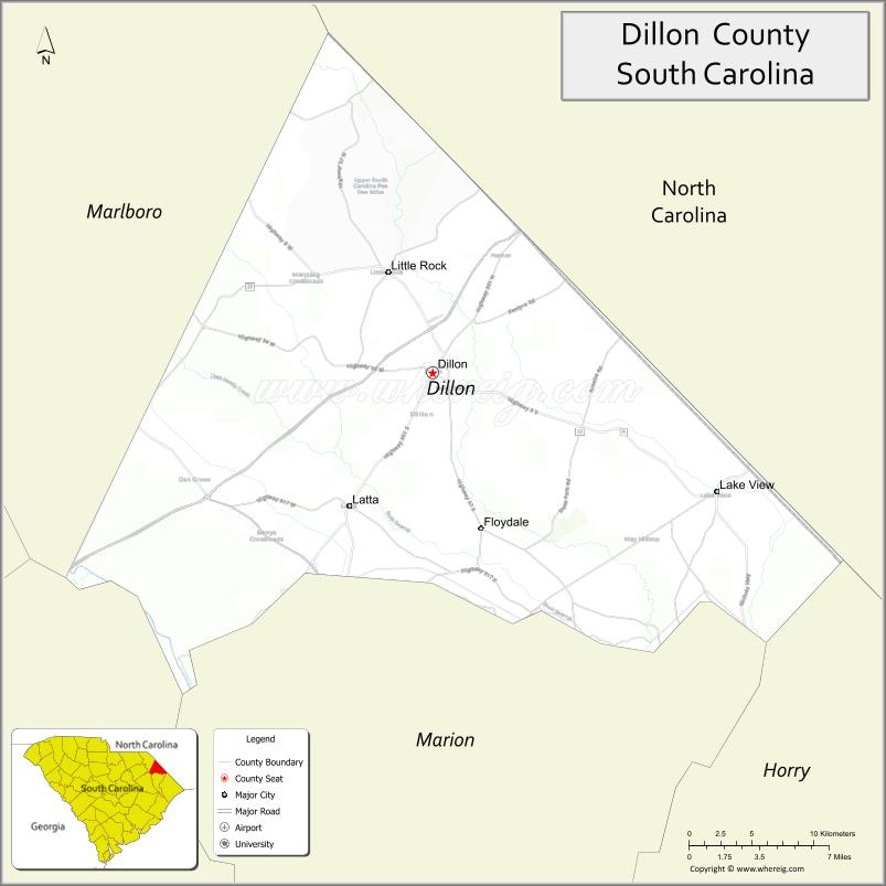
About Dillon County Map, South Carolina: The map showing the county boundary, county seat, major cities, highways, water bodies and neighbouring counties.
Related South Carolina Links
Map of Dillon County, South Carolina
Dillon County is a county located in the U.S. state of South Carolina. It's county seat is Dillon. As per 2020 census, the population of Dillon County is 28087 people and population density is square miles. According to the United States Census Bureau, the county has a total area of 407 sq mi (1,054 km2). Dillon County was established on 1910.
Dillon County Facts
| Continent | North America |
| Country | United States |
| State | South Carolina |
| County Seat | Dillon |
| Largest City/Town | Dillon |
| Established | 1910 |
| Total Area | 407.12 sq mi (1,054.44 sq km) |
| Land Area | 401.87 sq mi (1,040.84 sq km) |
| Water Area | 5.25 sq mi (13.60 sq km) |
| Population | 30,722 (Census 2020) |
| Population Density | 76.4 people per sq mi |
| Time Zone | Eastern (EST) |
| Major Highways | I-95, US-301, US-501, SC-9, SC-41 |
| Major Rivers | Little Pee Dee River, Lumber River |
| Neighboring Counties | Horry, Marion, Marlboro, Robeson (NC) |
| Famous For | Roadside attractions, agriculture, I-95 travel stop |
| Top Attractions | South of the Border, Little Pee Dee River, Dillon County Theater |
| Official Website | Official Website |
About Dillon County, South Carolina
Dillon County is located in the northeastern part of South Carolina in the United States and was established in 1910. The county seat is Dillon, which is also the largest city. The county lies in the Pee Dee region and features flat coastal plain terrain, farmland, and major highway access that makes it a key travel corridor along Interstate 95.
Cities and Towns in Dillon County, South Carolina
| City/Town | Population (Census 2020) | Latitude & Longitude |
|---|---|---|
| Dillon (county seat) | 6,384 | 34.4166N, 79.3712W |
| Lake View | 809 | 34.3440N, 79.1761W |
| Latta | 1,318 | 34.3374N, 79.4331W |
| Hamer | 274 | 34.4943N, 79.2992W |
| Little Rock (CDP) | ~N/A | 34.5140N, 79.3050W |
| Kemper (CDP) | ~N/A | 34.4300N, 79.3500W |
Golf Courses in Dillon County, South Carolina
| Golf Course | Location | Latitude & Longitude |
|---|---|---|
| Twin Lakes Golf & Country Club | Dillon | 34.4202N, 79.3690W |
| Dillon Country Club | Dillon | 34.4185N, 79.3752W |
Roads and Highways in Dillon County, South Carolina
The county is a key transportation hub due to its location along a major interstate.
- I-95 - major north-south interstate running through Dillon
- US-301 - parallels I-95 and connects local communities
- US-501 - connects Dillon to Myrtle Beach and inland areas
- SC-9 - links Dillon to North Carolina and surrounding counties
- SC-41 - connects rural parts of the county
Neighboring Counties of Dillon County
- Robeson County, North Carolina (north)
- Marlboro County (west)
- Marion County (south)
- Horry County (southeast)
Top Attractions in Dillon County, South Carolina
The county offers roadside attractions and natural scenery.
- South of the Border - famous roadside attraction on I-95
- Little Pee Dee River - fishing, kayaking, and scenic views
- Dillon County Theater - local performances and events
- Latta Historic District - small-town charm and history
- Dillon Motor Speedway - motorsports and racing events
- Local farms - agricultural landscapes and seasonal produce
Distance from Dillon County to Nearby Cities
- Dillon to Florence - 30 mi (48 km)
- Dillon to Myrtle Beach - 70 mi (113 km)
- Dillon to Columbia - 100 mi (161 km)
- Dillon to Charlotte - 110 mi (177 km)
- Dillon to Raleigh - 120 mi (193 km)
FAQs about Dillon County
Dillon County is located in the northeastern Pee Dee region of South Carolina near the North Carolina border.
The population of Dillon County is 30,722 according to the 2020 Census.
The county is known for its roadside attractions, agriculture, and location along Interstate 95.
Major highways include I-95, US-301, US-501, SC-9, and SC-41.
Yes, golf courses such as Twin Lakes Golf & Country Club and Dillon Country Club are located in the county.
- Abbeville County Map
- Aiken County Map
- Allendale County Map
- Anderson County Map
- Bamberg County Map
- Barnwell County Map
- Beaufort County Map
- Berkeley County Map
- Calhoun County Map
- Charleston County Map
- Cherokee County Map
- Chester County Map
- Chesterfield County Map
- Clarendon County Map
- Colleton County Map
- Darlington County Map
- Dillon County Map
- Dorchester County Map
- Edgefield County Map
- Fairfield County Map
- Florence County Map
- Georgetown County Map
- Greenville County Map
- Greenwood County Map
- Hampton County Map
- Horry County Map
- Jasper County Map
- Kershaw County Map
- Lancaster County Map
- Laurens County Map
- Lee County Map
- Lexington County Map
- McCormick County Map
- Marion County Map
- Marlboro County Map
- Newberry County Map
- Oconee County Map
- Orangeburg County Map
- Pickens County Map
- Richland County Map
- Saluda County Map
- Spartanburg County Map
- Sumter County Map
- Union County Map
- Williamsburg County Map
- York County Map
- Alabama Counties
- Alaska boroughs
- Arizona Counties
- Arkansas Counties
- California County Map
- Colorado Counties
- Connecticut Counties
- Delaware Counties
- Florida County Map
- Georgia County Map
- Hawaii Counties
- Idaho Counties
- Illinois Counties
- Indiana Counties
- Iowa Counties
- Kansas Counties
- Kentucky Counties
- Louisiana Counties
- Maine Counties
- Maryland Counties
- Massachusetts Counties
- Michigan County Map
- Minnesota Counties
- Mississippi Counties
- Missouri Counties
- Montana Counties
- Nebraska Counties
- Nevada Counties
- New York Counties
- New Hampshire Counties
- New Jersey Counties
- New Mexico Counties
- North Carolina Counties
- North Dakota Counties
- Ohio County Map
- Oklahoma Counties
- Oregon Counties
- Pennsylvania Counties
- Rhode Island Counties
- South Carolina Counties
- South Dakota Counties
- Map of Tennessee
- Texas County Map
- Utah Counties
- Vermont Counties
- Virginia Counties
- Washington Counties
- West Virginia Counties
- Wisconsin Counties
- Wyoming Counties