Written and Fact-checked by Whereig Editors | Updated On: May 05, 2026 | 14:50 ET
Map of Pickens County - Pickens County is a county located in the U.S. state of South Carolina. Pickens County Map showing cities, highways, important places and water bodies. Get Where is Pickens County located in the map, major cities in Pickens county, population, areas, and places of interest.
Map of Pickens County, South Carolina
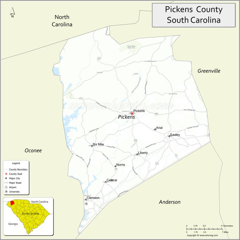
About Pickens County Map, South Carolina: The map showing the county boundary, county seat, major cities, highways, water bodies and neighbouring counties.
Related South Carolina Links
Map of Pickens County, South Carolina
Pickens County is a county located in the U.S. state of South Carolina. It's county seat is Pickens. As per 2020 census, the population of Pickens County is 132229 people and population density is square miles. According to the United States Census Bureau, the county has a total area of 512 sq mi (1,326 km2). Pickens County was established on 1826.
Pickens County Facts
| Continent | North America |
| Country | United States |
| State | South Carolina |
| County Seat | Pickens |
| Largest City/Town | Easley |
| Established | 1826 |
| Total Area | 512.75 sq mi (1,328.02 sq km) |
| Land Area | 496.81 sq mi (1,286.72 sq km) |
| Water Area | 15.94 sq mi (41.30 sq km) |
| Population | 131,063 (Census 2020) |
| Population Density | 263.8 people per sq mi |
| Time Zone | Eastern (EST) |
| Major Highways | US-123, US-178, SC-8, SC-11 |
| Major Rivers | Keowee River, Saluda River |
| Neighboring Counties | Greenville, Anderson, Oconee, Transylvania (NC), Henderson (NC) |
| Famous For | Clemson University, Blue Ridge Mountains, outdoor recreation |
| Top Attractions | Table Rock State Park, Lake Keowee, Clemson University, Sassafras Mountain |
| Official Website | Official Website |
About Pickens County, South Carolina
Pickens County is located in the northwestern part of South Carolina in the United States and was established in 1826. The county seat is Pickens, while the largest city is Easley. The county lies in the Upstate region along the foothills of the Blue Ridge Mountains and is known for Clemson University, scenic landscapes, and abundant outdoor recreation opportunities.
Cities and Towns in Pickens County, South Carolina
| City/Town | Population (Census 2020) | Latitude & Longitude |
|---|---|---|
| Easley | 22,921 | 34.8298N, 82.6015W |
| Clemson | 17,681 | 34.6834N, 82.8374W |
| Pickens (county seat) | 3,371 | 34.8835N, 82.7076W |
| Liberty | 3,200+ | 34.7879N, 82.6921W |
| Central | 5,300+ | 34.7240N, 82.7826W |
| Six Mile | 800 | 34.8068N, 82.8184W |
| Pickensville (CDP) | ~N/A | 34.9000N, 82.7200W |
Golf Courses in Pickens County, South Carolina
| Golf Course | Location | Latitude & Longitude |
|---|---|---|
| Pickens Country Club | Pickens | 34.8850N, 82.7100W |
| Southern Oaks Golf Course | Easley | 34.8300N, 82.6000W |
| Boscobel Golf & Country Club | Pendleton area | 34.6400N, 82.7800W |
Roads and Highways in Pickens County, South Carolina
The county is connected by major and scenic highways leading through the Upstate region.
- US-123 - major route connecting Greenville to Clemson
- US-178 - scenic route through the mountains
- SC-8 - connects Easley and Pickens to surrounding areas
- SC-11 - Cherokee Foothills Scenic Highway
Neighboring Counties of Pickens County
- Greenville County (east)
- Anderson County (south)
- Oconee County (west)
- Transylvania County, North Carolina (north)
- Henderson County, North Carolina (north)
Top Attractions in Pickens County, South Carolina
The county is known for outdoor recreation and scenic beauty.
- Table Rock State Park - hiking, camping, and scenic views
- Sassafras Mountain - highest point in South Carolina
- Lake Keowee - boating and fishing
- Clemson University - major educational and cultural center
- Devils Fork State Park - access to Lake Jocassee
- Keowee-Toxaway State Park - trails and lake views
Distance from Pickens County to Nearby Cities
- Easley to Greenville - 15 mi (24 km)
- Easley to Atlanta - 120 mi (193 km)
- Easley to Charlotte - 110 mi (177 km)
- Easley to Columbia - 130 mi (209 km)
- Easley to Asheville - 70 mi (113 km)
FAQs about Pickens County
Pickens County is located in the northwestern Upstate region of South Carolina along the Blue Ridge Mountains.
The population of Pickens County is 131,063 according to the 2020 Census.
The county is known for Clemson University, mountains, lakes, and outdoor recreation.
Major highways include US-123, US-178, SC-8, and SC-11.
Yes, Pickens Country Club and Southern Oaks Golf Course are located in the county.
- Abbeville County Map
- Aiken County Map
- Allendale County Map
- Anderson County Map
- Bamberg County Map
- Barnwell County Map
- Beaufort County Map
- Berkeley County Map
- Calhoun County Map
- Charleston County Map
- Cherokee County Map
- Chester County Map
- Chesterfield County Map
- Clarendon County Map
- Colleton County Map
- Darlington County Map
- Dillon County Map
- Dorchester County Map
- Edgefield County Map
- Fairfield County Map
- Florence County Map
- Georgetown County Map
- Greenville County Map
- Greenwood County Map
- Hampton County Map
- Horry County Map
- Jasper County Map
- Kershaw County Map
- Lancaster County Map
- Laurens County Map
- Lee County Map
- Lexington County Map
- McCormick County Map
- Marion County Map
- Marlboro County Map
- Newberry County Map
- Oconee County Map
- Orangeburg County Map
- Pickens County Map
- Richland County Map
- Saluda County Map
- Spartanburg County Map
- Sumter County Map
- Union County Map
- Williamsburg County Map
- York County Map
- Alabama Counties
- Alaska boroughs
- Arizona Counties
- Arkansas Counties
- California County Map
- Colorado Counties
- Connecticut Counties
- Delaware Counties
- Florida County Map
- Georgia County Map
- Hawaii Counties
- Idaho Counties
- Illinois Counties
- Indiana Counties
- Iowa Counties
- Kansas Counties
- Kentucky Counties
- Louisiana Counties
- Maine Counties
- Maryland Counties
- Massachusetts Counties
- Michigan County Map
- Minnesota Counties
- Mississippi Counties
- Missouri Counties
- Montana Counties
- Nebraska Counties
- Nevada Counties
- New York Counties
- New Hampshire Counties
- New Jersey Counties
- New Mexico Counties
- North Carolina Counties
- North Dakota Counties
- Ohio County Map
- Oklahoma Counties
- Oregon Counties
- Pennsylvania Counties
- Rhode Island Counties
- South Carolina Counties
- South Dakota Counties
- Map of Tennessee
- Texas County Map
- Utah Counties
- Vermont Counties
- Virginia Counties
- Washington Counties
- West Virginia Counties
- Wisconsin Counties
- Wyoming Counties