Written and Fact-checked by Whereig Editors | Updated On: May 05, 2026 | 14:50 ET
Map of Berkeley County - Berkeley County is a county located in the U.S. state of South Carolina. Berkeley County Map showing cities, highways, important places and water bodies. Get Where is Berkeley County located in the map, major cities in Berkeley county, population, areas, and places of interest.
Map of Berkeley County, South Carolina
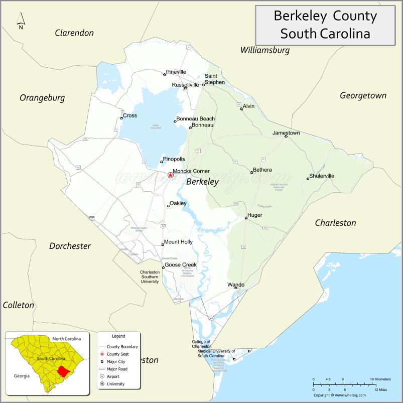
About Berkeley County Map, South Carolina: The map showing the county boundary, county seat, major cities, highways, water bodies and neighbouring counties.
Related South Carolina Links
Map of Berkeley County, South Carolina
Berkeley County is a county located in the U.S. state of South Carolina. It's county seat is Moncks Corner. As per 2020 census, the population of Berkeley County is 236701 people and population density is square miles. According to the United States Census Bureau, the county has a total area of 1,228 sq mi (3,181 km2). Berkeley County was established on 1882.
Berkeley County Facts
| Continent | North America |
| Country | United States |
| State | South Carolina |
| County Seat | Moncks Corner |
| Largest City/Town | Goose Creek |
| Established | 1882 |
| Total Area | 1,229.86 sq mi (3,185.35 sq km) |
| Land Area | 1,098.17 sq mi (2,844.25 sq km) |
| Water Area | 131.69 sq mi (341.10 sq km) |
| Population | 229,861 (Census 2020) |
| Population Density | 209.4 people per sq mi |
| Time Zone | Eastern (EST) |
| Major Highways | I-26, US-52, US-17A, SC-6, SC-176 |
| Major Rivers | Cooper River, Santee River, Wando River |
| Neighboring Counties | Charleston, Dorchester, Orangeburg, Williamsburg, Georgetown |
| Famous For | Lake Moultrie, Francis Marion National Forest, fast-growing suburbs |
| Top Attractions | Lake Moultrie, Cypress Gardens, Francis Marion National Forest, Old Santee Canal Park |
| Official Website | Official Website |
About Berkeley County, South Carolina
Berkeley County is located in the southeastern part of South Carolina in the United States and was established in 1882. The county seat is Moncks Corner, while the largest city is Goose Creek. The county lies within the Lowcountry region and features rivers, lakes, and forests, along with rapid suburban growth due to its proximity to Charleston.
Cities and Towns in Berkeley County, South Carolina
| City/Town | Population (Census 2020) | Latitude & Longitude |
|---|---|---|
| Goose Creek | 45,946 | 32.9810N, 80.0326W |
| Hanahan | 22,292 | 32.9185N, 80.0220W |
| Moncks Corner (county seat) | 13,297 | 33.1960N, 80.0131W |
| St. Stephen | 1,892 | 33.4046N, 79.9215W |
| Bonneau | 487 | 33.3054N, 79.9708W |
| Jamestown | 72 | 33.2805N, 79.6735W |
| Summerville (partly) | 50,915 | 33.0185N, 80.1756W |
| Charleston (partly) | 150,227 | 32.7765N, 79.9311W |
| Cane Bay (CDP) | 12,500+ | 33.0770N, 80.1650W |
| Sangaree (CDP) | 8,000+ | 33.0368N, 80.1609W |
| Cross (CDP) | 2,200+ | 33.3415N, 80.1504W |
Golf Courses in Berkeley County, South Carolina
| Golf Course | Location | Latitude & Longitude |
|---|---|---|
| Crowfield Golf Club | Goose Creek | 33.0185N, 80.0601W |
| Berkeley Country Club | Moncks Corner | 33.1872N, 80.0125W |
| Coosaw Creek Country Club (nearby access) | North Charleston area | 32.9205N, 80.0903W |
Roads and Highways in Berkeley County, South Carolina
The county has major highways that support commuting and regional travel.
- I-26 - major interstate connecting Charleston and Columbia
- US-52 - runs through Goose Creek and Moncks Corner
- US-17A - connects Summerville to Moncks Corner
- SC-6 - links rural areas and connects to Orangeburg
- SC-176 - runs parallel to I-26 through the county
Neighboring Counties of Berkeley County
- Georgetown County (north)
- Williamsburg County (northwest)
- Orangeburg County (west)
- Dorchester County (southwest)
- Charleston County (south)
Top Attractions in Berkeley County, South Carolina
The county features outdoor recreation and historic Lowcountry attractions.
- Lake Moultrie - large lake for fishing, boating, and camping
- Cypress Gardens - scenic swamp gardens and walking trails
- Francis Marion National Forest - hiking, wildlife, and nature
- Old Santee Canal Park - historic canal and interpretive center
- Bonneau Beach - relaxing lakeside area
- Moncks Corner Historic District - small-town charm and history
- Cooper River - boating and scenic views
- Santee River - major waterway for fishing and recreation
Distance from Berkeley County to Nearby Cities
- Moncks Corner to Charleston - 35 mi (56 km)
- Moncks Corner to Summerville - 25 mi (40 km)
- Moncks Corner to Columbia - 90 mi (145 km)
- Moncks Corner to Georgetown - 60 mi (97 km)
- Moncks Corner to Myrtle Beach - 90 mi (145 km)
FAQs about Berkeley County
Berkeley County is located in the southeastern part of South Carolina near Charleston.
The population of Berkeley County is 229,861 according to the 2020 Census.
The county is known for Lake Moultrie, Francis Marion National Forest, and rapid suburban growth.
Major highways include I-26, US-52, US-17A, SC-6, and SC-176.
Yes, golf courses such as Crowfield Golf Club and Berkeley Country Club are located in the county.
- Abbeville County Map
- Aiken County Map
- Allendale County Map
- Anderson County Map
- Bamberg County Map
- Barnwell County Map
- Beaufort County Map
- Berkeley County Map
- Calhoun County Map
- Charleston County Map
- Cherokee County Map
- Chester County Map
- Chesterfield County Map
- Clarendon County Map
- Colleton County Map
- Darlington County Map
- Dillon County Map
- Dorchester County Map
- Edgefield County Map
- Fairfield County Map
- Florence County Map
- Georgetown County Map
- Greenville County Map
- Greenwood County Map
- Hampton County Map
- Horry County Map
- Jasper County Map
- Kershaw County Map
- Lancaster County Map
- Laurens County Map
- Lee County Map
- Lexington County Map
- McCormick County Map
- Marion County Map
- Marlboro County Map
- Newberry County Map
- Oconee County Map
- Orangeburg County Map
- Pickens County Map
- Richland County Map
- Saluda County Map
- Spartanburg County Map
- Sumter County Map
- Union County Map
- Williamsburg County Map
- York County Map
- Alabama Counties
- Alaska boroughs
- Arizona Counties
- Arkansas Counties
- California County Map
- Colorado Counties
- Connecticut Counties
- Delaware Counties
- Florida County Map
- Georgia County Map
- Hawaii Counties
- Idaho Counties
- Illinois Counties
- Indiana Counties
- Iowa Counties
- Kansas Counties
- Kentucky Counties
- Louisiana Counties
- Maine Counties
- Maryland Counties
- Massachusetts Counties
- Michigan County Map
- Minnesota Counties
- Mississippi Counties
- Missouri Counties
- Montana Counties
- Nebraska Counties
- Nevada Counties
- New York Counties
- New Hampshire Counties
- New Jersey Counties
- New Mexico Counties
- North Carolina Counties
- North Dakota Counties
- Ohio County Map
- Oklahoma Counties
- Oregon Counties
- Pennsylvania Counties
- Rhode Island Counties
- South Carolina Counties
- South Dakota Counties
- Map of Tennessee
- Texas County Map
- Utah Counties
- Vermont Counties
- Virginia Counties
- Washington Counties
- West Virginia Counties
- Wisconsin Counties
- Wyoming Counties